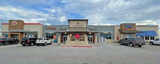
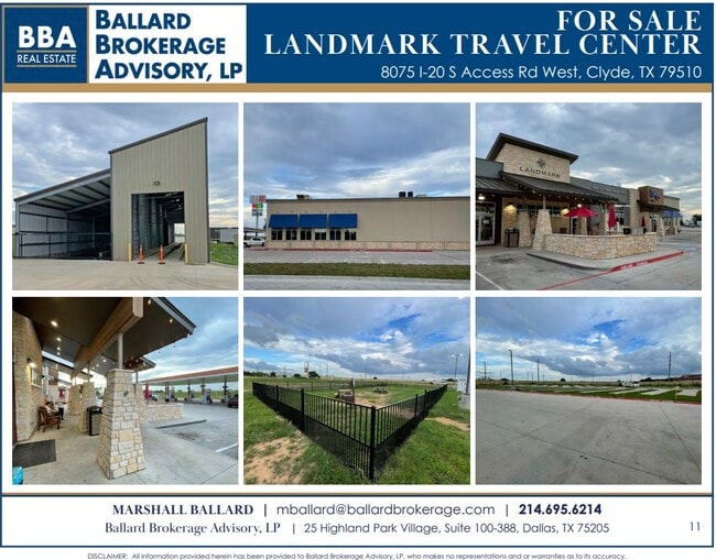
Property Record
8075 Interstate 20 Rd W, Clyde, TX 79510

Property Detail
8075 Interstate 20 Rd W
Abilene, TX
ACRES: 6.000 ABSTRACT 30 SEC 53 BBB&C
R000018701
CALLAHAN
Commercialnec
Texas
2025
6.57 AC
2025
Clyde
030102
Other Market Areas
NEARBY LISTINGS FOR SALE OR LEASE
-
-
View all Clyde listings for sale on LoopNet.com
DEMOGRAPHICS near 8075 Interstate 20 Rd W
1 mile
3 mile
5 mile
2025 Total Population
971
5,808
8,080
2030 Population
1,005
6,039
8,419
Pop Growth 2025-2030
+ 3.50%
+ 3.98%
+ 4.20%
Average Age
42
41
42
2025 Total Households
395
2,274
3,164
HH Growth 2025-2030
+ 3.29%
+ 3.78%
+ 3.98%
Median Household Inc
$66,375
$69,314
$70,510
Avg Household Size
2.50
2.50
2.50
2025 Avg HH Vehicles
2.00
2.00
2.00
Median Home Value
$153,205
$166,950
$175,950
Median Year Built
1966
1974
1977
Nearby Places
Map Layers
Map Styles
 Street
 Aerial
Transit
 Traffic
 Biking
Places
Listings with unknown addresses are not visible on the map
- Restaurants
- Banks
- Shops
- Fitness
- Groceries
PUBLIC TRANSPORTATION
AIRPORT
Abilene Regional
Drive
Walk
Distance
Abilene Regional
19 min
13.7 mi
Freight Ports
Port of Houston
Drive
Walk
Distance
Port of Houston
421 min
369.7 mi
SALE & LEASE HISTORY
LISTING DATE
SALE/LEASE

Jul 25, 2024
For Sale
Nearby Properties
Address
Land Use
TOTAL SIZE
Lot Size
Zoning
Address
Land Use
TOTAL SIZE
Lot Size
Zoning
56,150 SF
16.72 AC
Address
Land Use
TOTAL SIZE
Lot Size
Zoning
0.96 AC
Address
Land Use
TOTAL SIZE
Lot Size
Zoning
252,327 SF
5.57 AC
Address
Land Use
TOTAL SIZE
Lot Size
Zoning
76,932 SF
2.13 AC
Address
Land Use
TOTAL SIZE
Lot Size
Zoning
18,690 SF
1.61 AC
Address
Land Use
TOTAL SIZE
Lot Size
Zoning
26,159 SF
3.59 AC
Address
Land Use
TOTAL SIZE
Lot Size
Zoning
20,160 SF
5.07 AC
Address
Land Use
TOTAL SIZE
Lot Size
Zoning
17.40 AC
Address
Land Use
TOTAL SIZE
Lot Size
Zoning
18,168 SF
5 AC
Address
Land Use
TOTAL SIZE
Lot Size
Zoning
11,765 SF
0.96 AC
Address
Land Use
TOTAL SIZE
Lot Size
Zoning
26,634 SF
0.96 AC
Address
Land Use
TOTAL SIZE
Lot Size
Zoning
14,883 SF
1.18 AC
Address
Land Use
TOTAL SIZE
Lot Size
Zoning
7,951 SF
1.30 AC
Address
Land Use
TOTAL SIZE
Lot Size
Zoning
18,000 SF
6.24 AC
Address
Land Use
TOTAL SIZE
Lot Size
Zoning
8,596 SF
0.38 AC
Address
Land Use
TOTAL SIZE
Lot Size
Zoning
8,776 SF
14.04 AC
Address
Land Use
TOTAL SIZE
Lot Size
Zoning
6,336 SF
3.35 AC
Address
Land Use
TOTAL SIZE
Lot Size
Zoning
15,900 SF
1.17 AC
Address
Land Use
TOTAL SIZE
Lot Size
Zoning
43,684 SF
3.16 AC
Address
Land Use
TOTAL SIZE
Lot Size
Zoning
7,772 SF
2.75 AC
Address
Land Use
TOTAL SIZE
Lot Size
Zoning
40,726 SF
3.86 AC
Address
Land Use
TOTAL SIZE
Lot Size
Zoning
2.25 AC
Address
Land Use
TOTAL SIZE
Lot Size
Zoning
7,524 SF
4.89 AC
Address
Land Use
TOTAL SIZE
Lot Size
Zoning
4,671 SF
2.17 AC
Address
Land Use
TOTAL SIZE
Lot Size
Zoning
2,177 SF
0.89 AC
Address
Land Use
TOTAL SIZE
Lot Size
Zoning
5,800 SF
0.95 AC
Address
Land Use
TOTAL SIZE
Lot Size
Zoning
Address
Land Use
TOTAL SIZE
Lot Size
Zoning
14,350 SF
4.10 AC
Address
Land Use
TOTAL SIZE
Lot Size
Zoning
5,747 SF
0.48 AC
Address
Land Use
TOTAL SIZE
Lot Size
Zoning
11,180 SF
0.82 AC
The World's #1 Commercial Real Estate Marketplace
Connect with us
© 2026 CoStar Group
The information above has been obtained from sources believed reliable. While we do not doubt its accuracy we have not verified it and make no guarantee, warranty or representation about it. It is your responsibility to independently confirm its accuracy and completeness. Any projections, opinions, assumptions, or estimates used are for example only and do not represent the current or future performance of the property. The value of this transaction to you depends on tax and other factors which should be evaluated by your tax, financial, and legal advisors. You and your advisors should conduct a careful, independent investigation of the property to determine to your satisfaction the suitability of the property for your needs.