Property Record
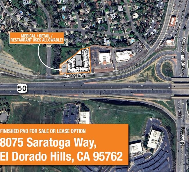
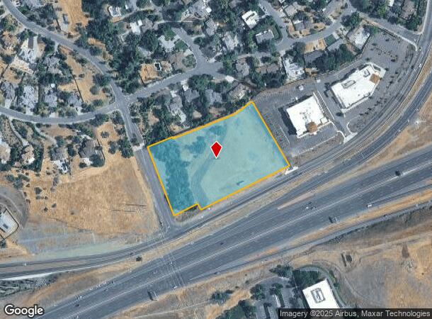
8075 Saratoga Way, El Dorado Hills, CA 95762
Current Lease Availabilities
NEARBY LISTINGS FOR SALE OR LEASE
-
-
View all El Dorado Hills listings for lease on LoopNet.com
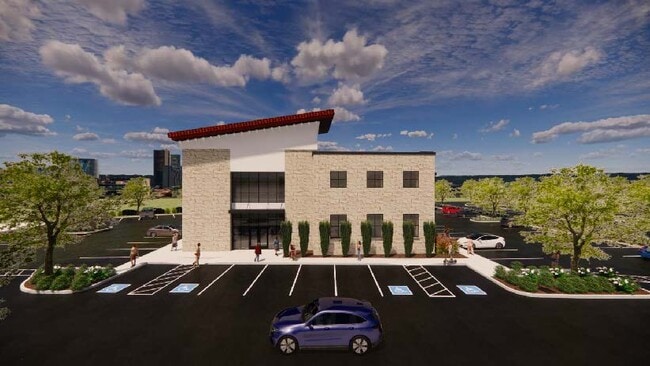
Property Detail
8075 Saratoga Way
Sacramento--Roseville--Arden-Arcade, CA
As Shown On That Certain Parcel Map
120-690-012-000
PM 51/133/3
Commercialacreage
El Dorado
X
California
06067C0139J
3.75 AC
2024
El Dorado
2025
Sacramento
030710
DEMOGRAPHICS near 8075 Saratoga Way
1 Mile
3 Mile
5 Mile
2024 Total Population
7,559
53,131
117,686
2029 Population
7,940
54,810
120,376
Pop Growth 2024-2029
+ 5.04%
+ 3.16%
+ 2.29%
Average Age
43
42
41
2024 Total Households
2,724
18,454
42,240
HH Growth 2024-2029
+ 5.07%
+ 3.22%
+ 2.30%
Median Household Inc
$124,125
$155,617
$139,294
Avg Household Size
2.70
2.80
2.70
2024 Avg HH Vehicles
2.00
2.00
2.00
Median Home Value
$740,153
$771,570
$748,311
Median Year Built
2006
2005
2000
Nearby Places
- Restaurants
- Banks
- Shops
- Fitness
- Groceries
PUBLIC TRANSPORTATION
AIRPORT
Sacramento International
DRIVE
WALK
Distance
Sacramento International
48 min
38.4 mi
Freight Ports
Port of Stockton
DRIVE
WALK
Distance
Port of Stockton
84 min
72.1 mi
Nearby Properties
Address
Land Use
TOTAL SIZE
Lot Size
Zoning
Address
Land Use
TOTAL SIZE
Lot Size
Zoning
352,146 SF
11.54 AC
SP-R-4 (SP
Address
Land Use
TOTAL SIZE
Lot Size
Zoning
Address
Land Use
TOTAL SIZE
Lot Size
Zoning
23.23 AC
SP-R-M (SP
Address
Land Use
TOTAL SIZE
Lot Size
Zoning
37.18 AC
SP-R-4 (SP
Address
Land Use
TOTAL SIZE
Lot Size
Zoning
8.54 AC
SP-MHD (PD
Address
Land Use
TOTAL SIZE
Lot Size
Zoning
243,460 SF
20.46 AC
C-3 (PD)
Address
Land Use
TOTAL SIZE
Lot Size
Zoning
553,153 SF
33.17 AC
Address
Land Use
TOTAL SIZE
Lot Size
Zoning
6.29 AC
SP-C-2 (SP
Address
Land Use
TOTAL SIZE
Lot Size
Zoning
203,397 SF
11.58 AC
SP-R-4 (SP
Address
Land Use
TOTAL SIZE
Lot Size
Zoning
114,835 SF
19.73 AC
SP-C-2 (SP
Address
Land Use
TOTAL SIZE
Lot Size
Zoning
296,680 SF
15.65 AC
R-M (PD)
Address
Land Use
TOTAL SIZE
Lot Size
Zoning
45,846 SF
12.62 AC
C-3 (PD)
Address
Land Use
TOTAL SIZE
Lot Size
Zoning
354,406 SF
23.94 AC
VVSP
Address
Land Use
TOTAL SIZE
Lot Size
Zoning
6.07 AC
SP-OS2 (SP
Address
Land Use
TOTAL SIZE
Lot Size
Zoning
154,998 SF
9.14 AC
M-L (PD)
Address
Land Use
TOTAL SIZE
Lot Size
Zoning
111,103 SF
11.33 AC
C-3 (PD)
Address
Land Use
TOTAL SIZE
Lot Size
Zoning
Address
Land Use
TOTAL SIZE
Lot Size
Zoning
148,663 SF
18.60 AC
SP-C-2 (SP
Address
Land Use
TOTAL SIZE
Lot Size
Zoning
127,600 SF
8.24 AC
CG
Address
Land Use
TOTAL SIZE
Lot Size
Zoning
Address
Land Use
TOTAL SIZE
Lot Size
Zoning
4.68 AC
R-4 (PD) M
Address
Land Use
TOTAL SIZE
Lot Size
Zoning
85,799 SF
4.67 AC
Address
Land Use
TOTAL SIZE
Lot Size
Zoning
296,680 SF
7.69 AC
R-M (PD)
Address
Land Use
TOTAL SIZE
Lot Size
Zoning
150,808 SF
14.91 AC
R2
Address
Land Use
TOTAL SIZE
Lot Size
Zoning
24.21 AC
C-3 (PD)
Address
Land Use
TOTAL SIZE
Lot Size
Zoning
50.99 AC
SP-GC (PD)
Address
Land Use
TOTAL SIZE
Lot Size
Zoning
76,737 SF
3.33 AC
C-3 (PD)
Address
Land Use
TOTAL SIZE
Lot Size
Zoning
8.85 AC
SP-SFHD (P
Address
Land Use
TOTAL SIZE
Lot Size
Zoning
93,440 SF
0.78 AC
C-3 (PD)
Address
Land Use
TOTAL SIZE
Lot Size
Zoning
524,157 SF
12.03 AC
VVSP
The World's #1 Commercial Real Estate Marketplace
Connect with us
© 2025 CoStar Group
The information above has been obtained from sources believed reliable. While we do not doubt its accuracy we have not verified it and make no guarantee, warranty or representation about it. It is your responsibility to independently confirm its accuracy and completeness. Any projections, opinions, assumptions, or estimates used are for example only and do not represent the current or future performance of the property. The value of this transaction to you depends on tax and other factors which should be evaluated by your tax, financial, and legal advisors. You and your advisors should conduct a careful, independent investigation of the property to determine to your satisfaction the suitability of the property for your needs.