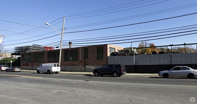
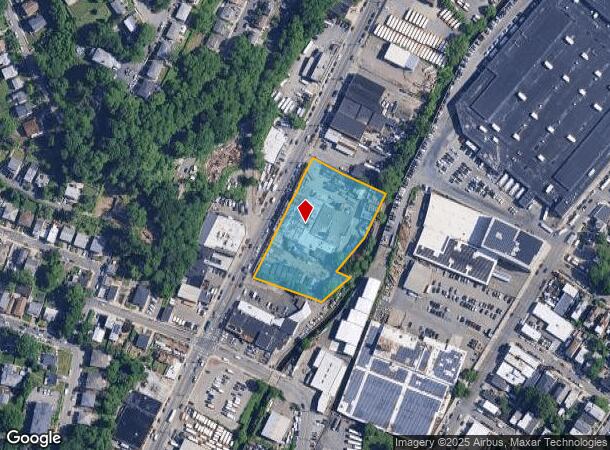
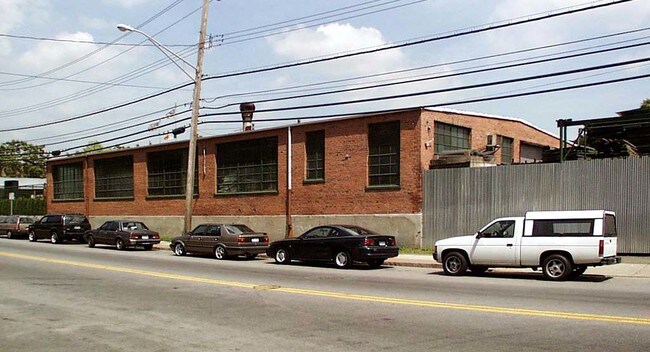
Property Record
808 Nepperhan Ave, Yonkers, NY 10703
NEARBY LISTINGS FOR SALE OR LEASE
Property Detail
808 Nepperhan Ave
1800-002-000-02390-000-0012-94
Revised Map Of Land Known As Yonkers Hei
Distributionwarehouseregional
Westchester
X
New York
34003C0210H
12.094
2025
2.07 AC
2024
Southwest
000802
Westchester/So Connecticut
22,390 SF
New York-Jersey City-White Plains, NY-NJ
DEMOGRAPHICS near 808 Nepperhan Ave
1 Mile
3 Mile
5 Mile
2024 Total Population
33,080
213,171
532,600
2029 Population
31,676
208,489
511,784
Pop Growth 2024-2029
(4.24%)
(2.20%)
(3.91%)
Average Age
41
41
41
2024 Total Households
12,102
81,219
198,219
HH Growth 2024-2029
(4.41%)
(2.30%)
(4.14%)
Median Household Inc
$85,339
$76,463
$84,022
Avg Household Size
2.60
2.50
2.60
2024 Avg HH Vehicles
1.00
1.00
1.00
Median Home Value
$423,113
$486,543
$598,933
Median Year Built
1954
1955
1953
Nearby Places
- Restaurants
- Banks
- Shops
- Fitness
- Groceries
PUBLIC TRANSPORTATION
COMMUTER RAIL
Yonkers Station (Hudson Line - Metro-North Commuter Railroad Company (Metro-North))
DRIVE
WALK
Distance
Yonkers Station (Hudson Line - Metro-North Commuter Railroad Company (Metro-North))
4 min
2.2 mi
Glenwood Station (Hudson Line - Metro-North Commuter Railroad Company (Metro-North))
DRIVE
WALK
Distance
Glenwood Station (Hudson Line - Metro-North Commuter Railroad Company (Metro-North))
8 min
2.3 mi
AIRPORT
LaGuardia
DRIVE
WALK
Distance
LaGuardia
30 min
18.1 mi
Westchester County
DRIVE
WALK
Distance
Westchester County
29 min
19.5 mi
John F Kennedy International
DRIVE
WALK
Distance
John F Kennedy International
43 min
27.0 mi
Freight Ports
NY - Red Hook Container Terminal
DRIVE
WALK
Distance
NY - Red Hook Container Terminal
43 min
26.3 mi
Nearby Properties
Address
Land Use
TOTAL SIZE
Lot Size
Zoning
Address
Land Use
TOTAL SIZE
Lot Size
Zoning
689 SF
423.72 AC
P
Address
Land Use
TOTAL SIZE
Lot Size
Zoning
289.02 AC
P
Address
Land Use
TOTAL SIZE
Lot Size
Zoning
201,590 SF
4.13 AC
BA
Address
Land Use
TOTAL SIZE
Lot Size
Zoning
229.55 AC
P
Address
Land Use
TOTAL SIZE
Lot Size
Zoning
301,156 SF
13.94 AC
A
Address
Land Use
TOTAL SIZE
Lot Size
Zoning
185.35 AC
P
Address
Land Use
TOTAL SIZE
Lot Size
Zoning
70,737 SF
1.67 AC
BB
Address
Land Use
TOTAL SIZE
Lot Size
Zoning
166.61 AC
P
Address
Land Use
TOTAL SIZE
Lot Size
Zoning
23.97 AC
Address
Land Use
TOTAL SIZE
Lot Size
Zoning
94.42 AC
P
Address
Land Use
TOTAL SIZE
Lot Size
Zoning
64,165 SF
3.24 AC
B
Address
Land Use
TOTAL SIZE
Lot Size
Zoning
Address
Land Use
TOTAL SIZE
Lot Size
Zoning
Address
Land Use
TOTAL SIZE
Lot Size
Zoning
54.65 AC
P
Address
Land Use
TOTAL SIZE
Lot Size
Zoning
Address
Land Use
TOTAL SIZE
Lot Size
Zoning
28.77 AC
Address
Land Use
TOTAL SIZE
Lot Size
Zoning
11.70 AC
R-30
Address
Land Use
TOTAL SIZE
Lot Size
Zoning
Address
Land Use
TOTAL SIZE
Lot Size
Zoning
7,855 SF
1.10 AC
C
Address
Land Use
TOTAL SIZE
Lot Size
Zoning
30.29 AC
P
Address
Land Use
TOTAL SIZE
Lot Size
Zoning
69.90 AC
R-20
Address
Land Use
TOTAL SIZE
Lot Size
Zoning
25.58 AC
P
Address
Land Use
TOTAL SIZE
Lot Size
Zoning
25 AC
P
Address
Land Use
TOTAL SIZE
Lot Size
Zoning
122.38 AC
R-30
Address
Land Use
TOTAL SIZE
Lot Size
Zoning
36,413 SF
0.89 AC
A
Address
Land Use
TOTAL SIZE
Lot Size
Zoning
34,560 SF
0.28 AC
BA
Address
Land Use
TOTAL SIZE
Lot Size
Zoning
23,116 SF
1.82 AC
C
Address
Land Use
TOTAL SIZE
Lot Size
Zoning
18.57 AC
P
Address
Land Use
TOTAL SIZE
Lot Size
Zoning
Address
Land Use
TOTAL SIZE
Lot Size
Zoning
9.06 AC
P
The World's #1 Commercial Real Estate Marketplace
Connect with us
© 2025 CoStar Group
The information above has been obtained from sources believed reliable. While we do not doubt its accuracy we have not verified it and make no guarantee, warranty or representation about it. It is your responsibility to independently confirm its accuracy and completeness. Any projections, opinions, assumptions, or estimates used are for example only and do not represent the current or future performance of the property. The value of this transaction to you depends on tax and other factors which should be evaluated by your tax, financial, and legal advisors. You and your advisors should conduct a careful, independent investigation of the property to determine to your satisfaction the suitability of the property for your needs.