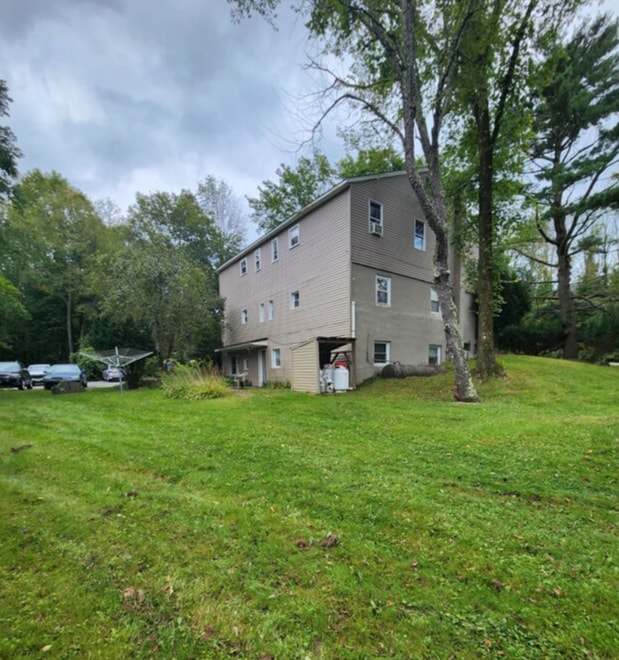
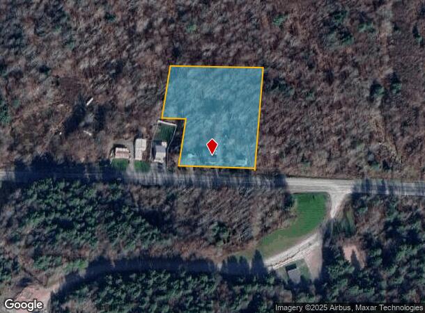
Property Record
808 State Route 17B, Monticello, NY 12701
NEARBY LISTINGS FOR SALE OR LEASE
-
-
View all Monticello listings for sale on LoopNet.com
Property Detail
808 State Route 17B
Apartment
Sullivan
X
New York
36105C0442F
2.001
2025
3.46 AC
2024
Hudson Valley Area
951600
Other Market Areas
2,632 SF
4689-017-0-0001-002-001
DEMOGRAPHICS near 808 State Route 17B
1 Mile
3 Mile
5 Mile
2024 Total Population
119
2,385
14,884
2029 Population
123
2,370
15,676
Pop Growth 2024-2029
+ 3.36%
(0.63%)
+ 5.32%
Average Age
45
44
41
2024 Total Households
50
987
6,029
HH Growth 2024-2029
+ 4.00%
(0.81%)
+ 5.46%
Median Household Inc
$71,249
$59,230
$44,351
Avg Household Size
2.10
2.20
2.30
2024 Avg HH Vehicles
2.00
2.00
2.00
Median Home Value
$243,750
$226,776
$182,736
Median Year Built
1972
1973
1974
Nearby Places
- Restaurants
- Banks
- Shops
- Fitness
- Groceries
SALE & LEASE HISTORY
LISTING DATE
SALE/LEASE

Oct 31, 2024
For Sale
Nearby Properties
Address
Land Use
TOTAL SIZE
Lot Size
Zoning
Address
Land Use
TOTAL SIZE
Lot Size
Zoning
3,980 SF
46.93 AC
HC2 / RR2
Address
Land Use
TOTAL SIZE
Lot Size
Zoning
222,345 SF
165.77 AC
B1
Address
Land Use
TOTAL SIZE
Lot Size
Zoning
1,600 SF
72.96 AC
CI / RR1
Address
Land Use
TOTAL SIZE
Lot Size
Zoning
7,360 SF
32.43 AC
RR
Address
Land Use
TOTAL SIZE
Lot Size
Zoning
27,686 SF
13.23 AC
NC
Address
Land Use
TOTAL SIZE
Lot Size
Zoning
19,392 SF
27.68 AC
HC2
Address
Land Use
TOTAL SIZE
Lot Size
Zoning
27,134 SF
10.73 AC
RR
Address
Land Use
TOTAL SIZE
Lot Size
Zoning
1,512 SF
427.07 AC
02 - SINGL
Address
Land Use
TOTAL SIZE
Lot Size
Zoning
960 SF
20.04 AC
RR1
Address
Land Use
TOTAL SIZE
Lot Size
Zoning
6,020 SF
5.32 AC
HC
Address
Land Use
TOTAL SIZE
Lot Size
Zoning
8,125 SF
158.59 AC
CI
Address
Land Use
TOTAL SIZE
Lot Size
Zoning
6,167 SF
5.52 AC
RR
Address
Land Use
TOTAL SIZE
Lot Size
Zoning
8,055 SF
11.13 AC
RR
Address
Land Use
TOTAL SIZE
Lot Size
Zoning
6,992 SF
43.88 AC
AR
Address
Land Use
TOTAL SIZE
Lot Size
Zoning
29.31 AC
B1
Address
Land Use
TOTAL SIZE
Lot Size
Zoning
37,360 SF
23.23 AC
02 - SINGL
Address
Land Use
TOTAL SIZE
Lot Size
Zoning
17.94 AC
RR
Address
Land Use
TOTAL SIZE
Lot Size
Zoning
1,072 SF
88.30 AC
RR2
Address
Land Use
TOTAL SIZE
Lot Size
Zoning
1,600 SF
27 AC
02 - SINGL
Address
Land Use
TOTAL SIZE
Lot Size
Zoning
18,360 SF
54.87 AC
02 - SINGL
Address
Land Use
TOTAL SIZE
Lot Size
Zoning
1,664 SF
23.96 AC
Address
Land Use
TOTAL SIZE
Lot Size
Zoning
5,418 SF
61.69 AC
AR
Address
Land Use
TOTAL SIZE
Lot Size
Zoning
900 SF
75.18 AC
AR
Address
Land Use
TOTAL SIZE
Lot Size
Zoning
9,100 SF
2.02 AC
Address
Land Use
TOTAL SIZE
Lot Size
Zoning
2,331 SF
97.95 AC
RR
Address
Land Use
TOTAL SIZE
Lot Size
Zoning
3,200 SF
56.59 AC
RR1
Address
Land Use
TOTAL SIZE
Lot Size
Zoning
16,400 SF
4.73 AC
HC1
Address
Land Use
TOTAL SIZE
Lot Size
Zoning
1,200 SF
6.65 AC
CI
Address
Land Use
TOTAL SIZE
Lot Size
Zoning
2,103 SF
115.50 AC
E
Address
Land Use
TOTAL SIZE
Lot Size
Zoning
1,344 SF
272.80 AC
RR1/RR2
The World's #1 Commercial Real Estate Marketplace
Connect with us
© 2025 CoStar Group
The information above has been obtained from sources believed reliable. While we do not doubt its accuracy we have not verified it and make no guarantee, warranty or representation about it. It is your responsibility to independently confirm its accuracy and completeness. Any projections, opinions, assumptions, or estimates used are for example only and do not represent the current or future performance of the property. The value of this transaction to you depends on tax and other factors which should be evaluated by your tax, financial, and legal advisors. You and your advisors should conduct a careful, independent investigation of the property to determine to your satisfaction the suitability of the property for your needs.