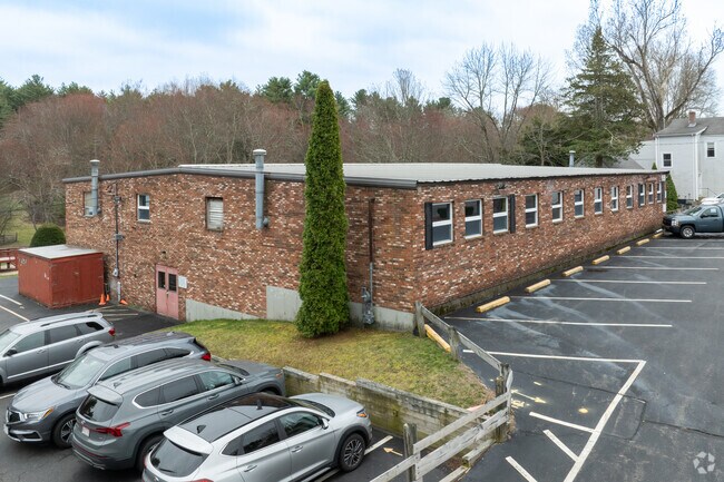
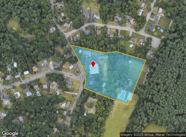
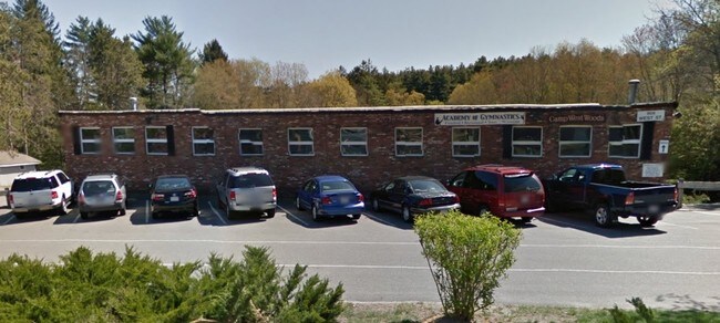
Property Record
808 West St, Stoughton, MA 02072
NEARBY LISTINGS FOR SALE OR LEASE
Property Detail
808 West St
STOU-000027-000112
Norfolk
Campgroundrvpark
Massachusetts
A
5.40 AC
25021C0376F
I-95 Corridor South
2025
Boston
2025
Boston-Cambridge-Newton, MA-NH
456402
DEMOGRAPHICS near 808 West St
1 Mile
3 Mile
5 Mile
2024 Total Population
4,273
45,335
114,147
2029 Population
4,231
45,014
113,285
Pop Growth 2024-2029
(0.98%)
(0.71%)
(0.76%)
Average Age
43
42
42
2024 Total Households
1,438
17,049
41,951
HH Growth 2024-2029
(0.97%)
(0.72%)
(0.79%)
Median Household Inc
$148,619
$110,004
$108,406
Avg Household Size
2.90
2.60
2.60
2024 Avg HH Vehicles
2.00
2.00
2.00
Median Home Value
$494,656
$493,258
$505,546
Median Year Built
1972
1968
1969
Nearby Places
Map Layers
Map Styles
 Street
 Aerial
- Restaurants
- Banks
- Shops
- Fitness
- Groceries
PUBLIC TRANSPORTATION
COMMUTER RAIL
Stoughton (Providence/Stoughton Line - Massachusetts Bay Transportation Authority Commuter Rail (Purple Line))
DRIVE
WALK
Distance
Stoughton (Providence/Stoughton Line - Massachusetts Bay Transportation Authority Commuter Rail (Purple Line))
5 min
2.1 mi
Canton Center (Providence/Stoughton Line - Massachusetts Bay Transportation Authority Commuter Rail (Purple Line))
DRIVE
WALK
Distance
Canton Center (Providence/Stoughton Line - Massachusetts Bay Transportation Authority Commuter Rail (Purple Line))
9 min
4.1 mi
AIRPORT
General Edward Lawrence Logan International
DRIVE
WALK
Distance
General Edward Lawrence Logan International
40 min
24.7 mi
Rhode Island Tf Green International
DRIVE
WALK
Distance
Rhode Island Tf Green International
62 min
38.7 mi
Nearby Properties
Address
Land Use
TOTAL SIZE
Lot Size
Zoning
Address
Land Use
TOTAL SIZE
Lot Size
Zoning
417,014 SF
10 AC
6
Address
Land Use
TOTAL SIZE
Lot Size
Zoning
56,088 SF
23.94 AC
I
Address
Land Use
TOTAL SIZE
Lot Size
Zoning
214,600 SF
20.30 AC
RU
Address
Land Use
TOTAL SIZE
Lot Size
Zoning
7.27 AC
GB
Address
Land Use
TOTAL SIZE
Lot Size
Zoning
196,398 SF
28.50 AC
Address
Land Use
TOTAL SIZE
Lot Size
Zoning
12.24 AC
I
Address
Land Use
TOTAL SIZE
Lot Size
Zoning
70,216 SF
6.86 AC
7
Address
Land Use
TOTAL SIZE
Lot Size
Zoning
103,901 SF
22.21 AC
Address
Land Use
TOTAL SIZE
Lot Size
Zoning
128,760 SF
19.51 AC
6
Address
Land Use
TOTAL SIZE
Lot Size
Zoning
107,467 SF
19.59 AC
Address
Land Use
TOTAL SIZE
Lot Size
Zoning
87,655 SF
3.39 AC
GB
Address
Land Use
TOTAL SIZE
Lot Size
Zoning
118,207 SF
10.90 AC
NB
Address
Land Use
TOTAL SIZE
Lot Size
Zoning
106,864 SF
26.70 AC
GB
Address
Land Use
TOTAL SIZE
Lot Size
Zoning
235,752 SF
18.58 AC
I
Address
Land Use
TOTAL SIZE
Lot Size
Zoning
265,013 SF
16.31 AC
I
Address
Land Use
TOTAL SIZE
Lot Size
Zoning
1,060 SF
103.22 AC
Address
Land Use
TOTAL SIZE
Lot Size
Zoning
64,689 SF
24.60 AC
5
Address
Land Use
TOTAL SIZE
Lot Size
Zoning
17,052 SF
33.53 AC
7
Address
Land Use
TOTAL SIZE
Lot Size
Zoning
120,887 SF
7.02 AC
RU
Address
Land Use
TOTAL SIZE
Lot Size
Zoning
5 AC
RU
Address
Land Use
TOTAL SIZE
Lot Size
Zoning
79,132 SF
21.54 AC
Address
Land Use
TOTAL SIZE
Lot Size
Zoning
76,598 SF
14.39 AC
Address
Land Use
TOTAL SIZE
Lot Size
Zoning
5.42 AC
RM
Address
Land Use
TOTAL SIZE
Lot Size
Zoning
74,789 SF
5.31 AC
GB
Address
Land Use
TOTAL SIZE
Lot Size
Zoning
255,544 SF
18.41 AC
I
Address
Land Use
TOTAL SIZE
Lot Size
Zoning
64,125 SF
1.02 AC
F
Address
Land Use
TOTAL SIZE
Lot Size
Zoning
74,596 SF
6.42 AC
GB
Address
Land Use
TOTAL SIZE
Lot Size
Zoning
317 AC
Address
Land Use
TOTAL SIZE
Lot Size
Zoning
48,277 SF
2.59 AC
Address
Land Use
TOTAL SIZE
Lot Size
Zoning
99,171 SF
4.69 AC
5
The World's #1 Commercial Real Estate Marketplace
Connect with us
© 2025 CoStar Group
The information above has been obtained from sources believed reliable. While we do not doubt its accuracy we have not verified it and make no guarantee, warranty or representation about it. It is your responsibility to independently confirm its accuracy and completeness. Any projections, opinions, assumptions, or estimates used are for example only and do not represent the current or future performance of the property. The value of this transaction to you depends on tax and other factors which should be evaluated by your tax, financial, and legal advisors. You and your advisors should conduct a careful, independent investigation of the property to determine to your satisfaction the suitability of the property for your needs.