Property Record
8085 Old Us 23, Fenton, MI 48430
NEARBY LISTINGS FOR SALE OR LEASE
-
-
View all Fenton listings for sale on LoopNet.com
Property Detail
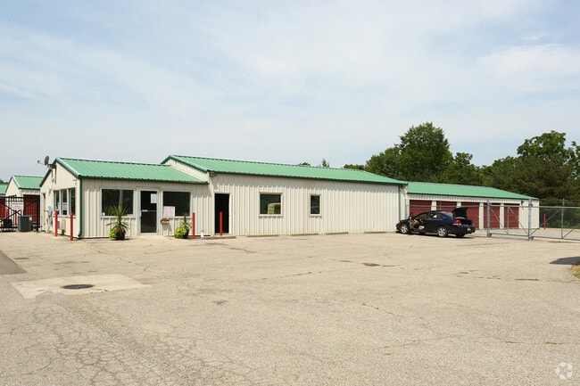
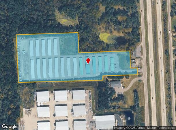
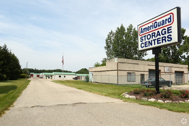
8085 Old Us 23
04-20-400-014
Part Of Sec 20 T4n R6e
Commercialnec
SEC 20 T4N R6E BEG AT PT 1302.27 FT W AND N 865.24 FT FROM THE SE CORNER OF SEC 20, TH N 473.75 FT, TH E 645.94 FT, TH S 200
X
Livingston
26093C0225D
Michigan
2025
10.15 AC
2025
Livingston County
710300
Detroit
96,750 SF
Detroit-Warren-Dearborn, MI
DEMOGRAPHICS near 8085 Old Us 23
1 Mile
3 Mile
5 Mile
2024 Total Population
518
8,065
22,920
2029 Population
529
8,261
23,227
Pop Growth 2024-2029
+ 2.12%
+ 2.43%
+ 1.34%
Average Age
40
40
42
2024 Total Households
180
2,850
8,322
HH Growth 2024-2029
+ 2.22%
+ 2.39%
+ 1.21%
Median Household Inc
$99,241
$99,270
$100,663
Avg Household Size
2.90
2.80
2.70
2024 Avg HH Vehicles
3.00
2.00
2.00
Median Home Value
$403,750
$387,391
$349,547
Median Year Built
1986
1987
1987
Nearby Places
Map Layers
Map Styles
 Street
 Aerial
- Restaurants
- Banks
- Shops
- Fitness
- Groceries
PUBLIC TRANSPORTATION
AIRPORT
Bishop International
DRIVE
WALK
Distance
Bishop International
32 min
19.5 mi
Freight Ports
Port of Toledo
DRIVE
WALK
Distance
Port of Toledo
112 min
93.4 mi
Nearby Properties
Address
Land Use
TOTAL SIZE
Lot Size
Zoning
Address
Land Use
TOTAL SIZE
Lot Size
Zoning
7,662 SF
150 AC
MHP
Address
Land Use
TOTAL SIZE
Lot Size
Zoning
192,000 SF
30.75 AC
M-1
Address
Land Use
TOTAL SIZE
Lot Size
Zoning
131,290 SF
22.33 AC
PCI
Address
Land Use
TOTAL SIZE
Lot Size
Zoning
8,902 SF
233.33 AC
RE
Address
Land Use
TOTAL SIZE
Lot Size
Zoning
2,656 SF
66 AC
MHP
Address
Land Use
TOTAL SIZE
Lot Size
Zoning
7,343 SF
95 AC
FR
Address
Land Use
TOTAL SIZE
Lot Size
Zoning
20.71 AC
MHP
Address
Land Use
TOTAL SIZE
Lot Size
Zoning
19,220 SF
38.65 AC
RE
Address
Land Use
TOTAL SIZE
Lot Size
Zoning
3,955 SF
110.41 AC
FR
Address
Land Use
TOTAL SIZE
Lot Size
Zoning
2,551 SF
157.94 AC
A-1
Address
Land Use
TOTAL SIZE
Lot Size
Zoning
74.50 AC
FR
Address
Land Use
TOTAL SIZE
Lot Size
Zoning
4,523 SF
65.42 AC
CA
Address
Land Use
TOTAL SIZE
Lot Size
Zoning
173.30 AC
A-1
Address
Land Use
TOTAL SIZE
Lot Size
Zoning
6,952 SF
10.50 AC
FR
Address
Land Use
TOTAL SIZE
Lot Size
Zoning
50 AC
FR
Address
Land Use
TOTAL SIZE
Lot Size
Zoning
3,876 SF
7.89 AC
RE
Address
Land Use
TOTAL SIZE
Lot Size
Zoning
139 AC
FR
Address
Land Use
TOTAL SIZE
Lot Size
Zoning
60 AC
FR
Address
Land Use
TOTAL SIZE
Lot Size
Zoning
3,288 SF
93.58 AC
FR
Address
Land Use
TOTAL SIZE
Lot Size
Zoning
5,382 SF
1.75 AC
ES
Address
Land Use
TOTAL SIZE
Lot Size
Zoning
48.10 AC
MHP
Address
Land Use
TOTAL SIZE
Lot Size
Zoning
117 AC
CA
Address
Land Use
TOTAL SIZE
Lot Size
Zoning
9,148 SF
28.79 AC
B-2
Address
Land Use
TOTAL SIZE
Lot Size
Zoning
118.28 AC
FR
Address
Land Use
TOTAL SIZE
Lot Size
Zoning
2,580 SF
67.51 AC
FR
Address
Land Use
TOTAL SIZE
Lot Size
Zoning
2,002 SF
79 AC
FR
Address
Land Use
TOTAL SIZE
Lot Size
Zoning
780 SF
14.24 AC
PCI
Address
Land Use
TOTAL SIZE
Lot Size
Zoning
80 AC
A-1
Address
Land Use
TOTAL SIZE
Lot Size
Zoning
80 AC
A-1
The World's #1 Commercial Real Estate Marketplace
Connect with us
© 2026 CoStar Group
The information above has been obtained from sources believed reliable. While we do not doubt its accuracy we have not verified it and make no guarantee, warranty or representation about it. It is your responsibility to independently confirm its accuracy and completeness. Any projections, opinions, assumptions, or estimates used are for example only and do not represent the current or future performance of the property. The value of this transaction to you depends on tax and other factors which should be evaluated by your tax, financial, and legal advisors. You and your advisors should conduct a careful, independent investigation of the property to determine to your satisfaction the suitability of the property for your needs.