Property Record
809 Abbott Rd, Buffalo, NY 14220
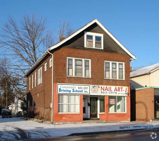


Property Detail
809 Abbott Rd
140200-133-570-0002-019-000
77.26 S COOLIDGE 138S 35 R
Commercialofficeresidentialmixeduse
Erie
N-3C
New York
B and X Area of moderate flood hazard, usually the area between the limits of the 100-year and 500-year floods.
19.000
2025
0.11 AC
2025
Greater Buffalo
000700
Buffalo/Niagara Falls
2,704 SF
Buffalo-Cheektowaga, NY
NEARBY LISTINGS FOR SALE OR LEASE
DEMOGRAPHICS near 809 Abbott Rd
1 mile
3 mile
5 mile
2025 Total Population
21,686
80,905
195,687
2030 Population
20,925
79,370
193,381
Pop Growth 2025-2030
(3.51%)
(1.90%)
(1.18%)
Average Age
41
41
41
2025 Total Households
9,585
35,315
85,642
HH Growth 2025-2030
(3.62%)
(1.93%)
(1.10%)
Median Household Inc
$67,978
$59,511
$56,948
Avg Household Size
2.20
2.20
2.20
2025 Avg HH Vehicles
2.00
1.00
1.00
Median Home Value
$194,045
$173,333
$186,981
Median Year Built
1947
1949
1953
Nearby Places
Map Layers
Map Styles
 Street
 Aerial
Layers
 Traffic
 Biking
Places
Listings with unknown addresses are not visible on the map
- Restaurants
- Banks
- Shops
- Fitness
- Groceries
PUBLIC TRANSPORTATION
COMMUTER RAIL
Drive
Walk
Distance
11 min
5.5 mi
Drive
Walk
Distance
18 min
8.4 mi
AIRPORT
Buffalo Niagara International
Drive
Walk
Distance
Buffalo Niagara International
24 min
11.5 mi
Niagara Falls International
Drive
Walk
Distance
Niagara Falls International
39 min
25.2 mi
Nearby Properties
Address
Land Use
TOTAL SIZE
Lot Size
Zoning
Address
Land Use
TOTAL SIZE
Lot Size
Zoning
1,053,391 SF
88.26 AC
D-IL
Address
Land Use
TOTAL SIZE
Lot Size
Zoning
425,796 SF
7.10 AC
D-M
Address
Land Use
TOTAL SIZE
Lot Size
Zoning
6,514 SF
68.20 AC
D-OG
Address
Land Use
TOTAL SIZE
Lot Size
Zoning
2,600 SF
14.80 AC
D-IL
Address
Land Use
TOTAL SIZE
Lot Size
Zoning
80,440 SF
1.54 AC
N-1C
Address
Land Use
TOTAL SIZE
Lot Size
Zoning
314,904 SF
30.05 AC
D-IL
Address
Land Use
TOTAL SIZE
Lot Size
Zoning
279,026 SF
25.08 AC
D-IL
Address
Land Use
TOTAL SIZE
Lot Size
Zoning
182,741 SF
7.02 AC
D-IL
Address
Land Use
TOTAL SIZE
Lot Size
Zoning
10,000 SF
58.57 AC
D-OG
Address
Land Use
TOTAL SIZE
Lot Size
Zoning
257,258 SF
51.55 AC
D-IL
Address
Land Use
TOTAL SIZE
Lot Size
Zoning
86,728 SF
1.40 AC
N-2C
Address
Land Use
TOTAL SIZE
Lot Size
Zoning
198,558 SF
3.16 AC
N-3R
Address
Land Use
TOTAL SIZE
Lot Size
Zoning
972 SF
194.01 AC
D-OG
Address
Land Use
TOTAL SIZE
Lot Size
Zoning
702.40 AC
IND
Address
Land Use
TOTAL SIZE
Lot Size
Zoning
48.14 AC
OP
Address
Land Use
TOTAL SIZE
Lot Size
Zoning
104,881 SF
24.43 AC
12
Address
Land Use
TOTAL SIZE
Lot Size
Zoning
151,200 SF
8.36 AC
BETH
Address
Land Use
TOTAL SIZE
Lot Size
Zoning
151,200 SF
8.29 AC
IND
Address
Land Use
TOTAL SIZE
Lot Size
Zoning
43,942 SF
14.34 AC
CBD
Address
Land Use
TOTAL SIZE
Lot Size
Zoning
264,816 SF
2.08 AC
D-M
Address
Land Use
TOTAL SIZE
Lot Size
Zoning
195,103 SF
15.30 AC
D-OG
Address
Land Use
TOTAL SIZE
Lot Size
Zoning
3,520 SF
13.22 AC
D-IL
Address
Land Use
TOTAL SIZE
Lot Size
Zoning
Address
Land Use
TOTAL SIZE
Lot Size
Zoning
172,398 SF
9.64 AC
D-IL
Address
Land Use
TOTAL SIZE
Lot Size
Zoning
124,112 SF
53.10 AC
05 - COMME
Address
Land Use
TOTAL SIZE
Lot Size
Zoning
110,150 SF
39.23 AC
IND
Address
Land Use
TOTAL SIZE
Lot Size
Zoning
7,440 SF
0.74 AC
N-3R
Address
Land Use
TOTAL SIZE
Lot Size
Zoning
4.47 AC
D-ON
Address
Land Use
TOTAL SIZE
Lot Size
Zoning
205,680 SF
37.40 AC
11
Address
Land Use
TOTAL SIZE
Lot Size
Zoning
159,611 SF
31.07 AC
D-IL
The World's #1 Commercial Real Estate Marketplace
Connect with us
© 2026 CoStar Group
The information above has been obtained from sources believed reliable. While we do not doubt its accuracy we have not verified it and make no guarantee, warranty or representation about it. It is your responsibility to independently confirm its accuracy and completeness. Any projections, opinions, assumptions, or estimates used are for example only and do not represent the current or future performance of the property. The value of this transaction to you depends on tax and other factors which should be evaluated by your tax, financial, and legal advisors. You and your advisors should conduct a careful, independent investigation of the property to determine to your satisfaction the suitability of the property for your needs.