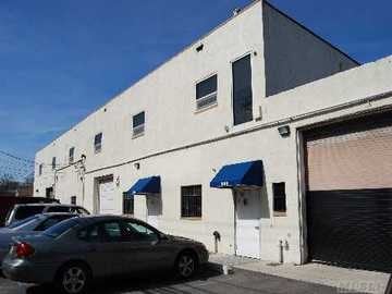
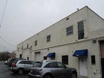
Property Record
809 Albin Ave, Lindenhurst, NY 11757
NEARBY LISTINGS FOR SALE OR LEASE
Property Detail
809 Albin Ave
Nassau County-Suffolk County, NY
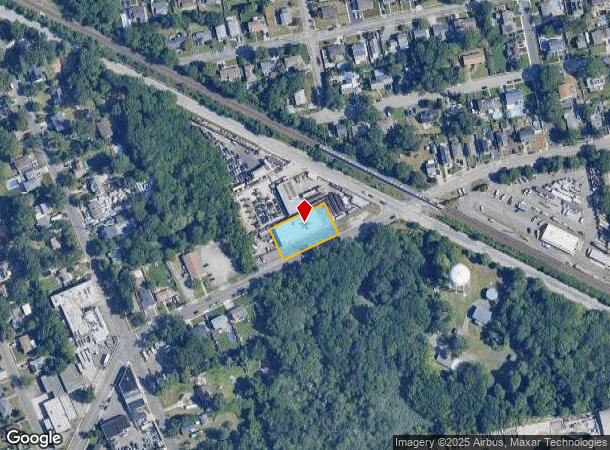
Map Woodland Park
0100-214-00-01-00-212-000
FILED MAP 548 BLK 34 LOTS 16-24 INC.
Industrialgeneral
Suffolk
X
New York
36103C0853H
212
2024
0.41 AC
2024
Southwest Suffolk
124302
Long Island (New York)
DEMOGRAPHICS near 809 Albin Ave
1 mile
3 mile
5 mile
2024 Total Population
17,953
131,902
270,323
2029 Population
17,479
128,789
264,474
Pop Growth 2024-2029
(2.64%)
(2.36%)
(2.16%)
Average Age
42
41
41
2024 Total Households
6,306
43,109
88,511
HH Growth 2024-2029
(2.87%)
(2.58%)
(2.37%)
Median Household Inc
$108,096
$110,559
$113,157
Avg Household Size
2.70
2.90
2.90
2024 Avg HH Vehicles
2.00
2.00
2.00
Median Home Value
$452,142
$447,889
$465,078
Median Year Built
1961
1960
1960
Nearby Places
Map Layers
Map Styles
 Street
 Aerial
Transit
 Traffic
 Biking
Places
Listings with unknown addresses are not visible on the map
- Restaurants
- Banks
- Shops
- Fitness
- Groceries
PUBLIC TRANSPORTATION
COMMUTER RAIL
Lindenhurst Station (Babylon Branch - Long Island Rail Road)
Drive
Walk
Distance
Lindenhurst Station (Babylon Branch - Long Island Rail Road)
3 min
1.2 mi
Babylon Station (Babylon Branch - Long Island Rail Road, Montauk Branch - Long Island Rail Road)
Drive
Walk
Distance
Babylon Station (Babylon Branch - Long Island Rail Road, Montauk Branch - Long Island Rail Road)
5 min
2.1 mi
AIRPORT
Long Island MacArthur
Drive
Walk
Distance
Long Island MacArthur
28 min
18.4 mi
John F Kennedy International
Drive
Walk
Distance
John F Kennedy International
39 min
26.4 mi
LaGuardia
Drive
Walk
Distance
LaGuardia
49 min
33.4 mi
Freight Ports
NY - Red Hook Container Terminal
Drive
Walk
Distance
NY - Red Hook Container Terminal
60 min
37.9 mi
Nearby Properties
Address
Land Use
TOTAL SIZE
Lot Size
Zoning
Address
Land Use
TOTAL SIZE
Lot Size
Zoning
37,072 SF
14.68 AC
R60
Address
Land Use
TOTAL SIZE
Lot Size
Zoning
4,172 SF
0.88 AC
R60
Address
Land Use
TOTAL SIZE
Lot Size
Zoning
6,026 SF
2.40 AC
VILLA
Address
Land Use
TOTAL SIZE
Lot Size
Zoning
20 AC
A
Address
Land Use
TOTAL SIZE
Lot Size
Zoning
5,040 SF
0.70 AC
VILLA
Address
Land Use
TOTAL SIZE
Lot Size
Zoning
2,418 SF
0.15 AC
VILLA
Address
Land Use
TOTAL SIZE
Lot Size
Zoning
20.50 AC
B
Address
Land Use
TOTAL SIZE
Lot Size
Zoning
2,140 SF
0.19 AC
VILLA
Address
Land Use
TOTAL SIZE
Lot Size
Zoning
2,416 SF
0.28 AC
VILLA
Address
Land Use
TOTAL SIZE
Lot Size
Zoning
4,290 SF
1.50 AC
VILLA
Address
Land Use
TOTAL SIZE
Lot Size
Zoning
2,627 SF
0.36 AC
VILLA
Address
Land Use
TOTAL SIZE
Lot Size
Zoning
2,864 SF
0.77 AC
VILLA
Address
Land Use
TOTAL SIZE
Lot Size
Zoning
3,917 SF
0.85 AC
CR200
Address
Land Use
TOTAL SIZE
Lot Size
Zoning
9,309 SF
1.02 AC
R40
Address
Land Use
TOTAL SIZE
Lot Size
Zoning
9.95 AC
BUS3
Address
Land Use
TOTAL SIZE
Lot Size
Zoning
18.70 AC
A
Address
Land Use
TOTAL SIZE
Lot Size
Zoning
3,366 SF
0.64 AC
R40
Address
Land Use
TOTAL SIZE
Lot Size
Zoning
3,778 SF
0.93 AC
R40
Address
Land Use
TOTAL SIZE
Lot Size
Zoning
2,969 SF
2.50 AC
R40
Address
Land Use
TOTAL SIZE
Lot Size
Zoning
14.60 AC
A
Address
Land Use
TOTAL SIZE
Lot Size
Zoning
24.90 AC
B
Address
Land Use
TOTAL SIZE
Lot Size
Zoning
9.70 AC
B
Address
Land Use
TOTAL SIZE
Lot Size
Zoning
19.40 AC
IND1
Address
Land Use
TOTAL SIZE
Lot Size
Zoning
3,489 SF
0.41 AC
CR40
Address
Land Use
TOTAL SIZE
Lot Size
Zoning
4,246 SF
1.87 AC
CR80
Address
Land Use
TOTAL SIZE
Lot Size
Zoning
3,728 SF
3 AC
AA
Address
Land Use
TOTAL SIZE
Lot Size
Zoning
3,092 SF
1.01 AC
R40
Address
Land Use
TOTAL SIZE
Lot Size
Zoning
4,267 SF
1.19 AC
R40
Address
Land Use
TOTAL SIZE
Lot Size
Zoning
5,142 SF
1 AC
CR80
Address
Land Use
TOTAL SIZE
Lot Size
Zoning
3,954 SF
0.94 AC
R40
The World's #1 Commercial Real Estate Marketplace
Connect with us
© 2026 CoStar Group
The information above has been obtained from sources believed reliable. While we do not doubt its accuracy we have not verified it and make no guarantee, warranty or representation about it. It is your responsibility to independently confirm its accuracy and completeness. Any projections, opinions, assumptions, or estimates used are for example only and do not represent the current or future performance of the property. The value of this transaction to you depends on tax and other factors which should be evaluated by your tax, financial, and legal advisors. You and your advisors should conduct a careful, independent investigation of the property to determine to your satisfaction the suitability of the property for your needs.