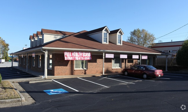
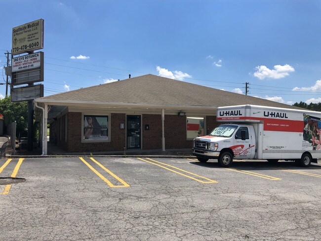
Property Record
809 Flint River Rd, Jonesboro, GA 30238
NEARBY LISTINGS FOR SALE OR LEASE
Property Detail
809 Flint River Rd
Officebuilding
Clayton
X
Georgia
13063C0088F
0.41 AC
2025
South Clayton/Henry Cnty
2025
Atlanta
040634
Atlanta-Sandy Springs-Roswell, GA
4,125 SF
13-0242D-00A-013
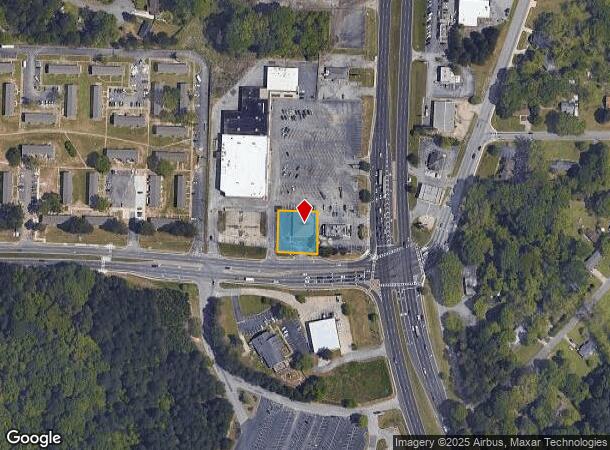
DEMOGRAPHICS near 809 Flint River Rd
1 Mile
3 Mile
5 Mile
2024 Total Population
6,251
69,034
155,894
2029 Population
6,222
68,671
155,685
Pop Growth 2024-2029
(0.46%)
(0.53%)
(0.13%)
Average Age
36
36
37
2024 Total Households
2,120
24,153
55,180
HH Growth 2024-2029
(0.57%)
(0.57%)
(0.14%)
Median Household Inc
$35,214
$57,707
$57,812
Avg Household Size
2.80
2.80
2.70
2024 Avg HH Vehicles
2.00
2.00
2.00
Median Home Value
$156,676
$177,639
$179,525
Median Year Built
1976
1985
1987
Nearby Places
Map Layers
Map Styles
 Street
 Aerial
- Restaurants
- Banks
- Shops
- Fitness
- Groceries
PUBLIC TRANSPORTATION
AIRPORT
Hartsfield - Jackson Atlanta International
DRIVE
WALK
Distance
Hartsfield - Jackson Atlanta International
20 min
11.2 mi
SALE & LEASE HISTORY
LISTING DATE
SALE/LEASE

Nov 03, 2016
For Lease
Jun 27, 2018
For Lease
Jun 01, 2017
For Lease
Feb 11, 2019
For Sale
Feb 10, 2021
For Sale
Aug 10, 2017
For Lease
Aug 02, 2019
For Sale
Apr 04, 2018
For Sale
Nearby Properties
Address
Land Use
TOTAL SIZE
Lot Size
Zoning
Address
Land Use
TOTAL SIZE
Lot Size
Zoning
231,046 SF
97.58 AC
C
Address
Land Use
TOTAL SIZE
Lot Size
Zoning
7,851 SF
94.84 AC
RS180
Address
Land Use
TOTAL SIZE
Lot Size
Zoning
194,682 SF
27.80 AC
OI
Address
Land Use
TOTAL SIZE
Lot Size
Zoning
324 SF
49.49 AC
RM
Address
Land Use
TOTAL SIZE
Lot Size
Zoning
11.31 AC
RM
Address
Land Use
TOTAL SIZE
Lot Size
Zoning
250 SF
31.25 AC
RM
Address
Land Use
TOTAL SIZE
Lot Size
Zoning
123,000 SF
48 AC
RS110
Address
Land Use
TOTAL SIZE
Lot Size
Zoning
424 SF
54.79 AC
RM
Address
Land Use
TOTAL SIZE
Lot Size
Zoning
230 SF
27.09 AC
RM
Address
Land Use
TOTAL SIZE
Lot Size
Zoning
123,842 SF
31.53 AC
RS110
Address
Land Use
TOTAL SIZE
Lot Size
Zoning
351,207 SF
20 AC
HI
Address
Land Use
TOTAL SIZE
Lot Size
Zoning
316 SF
34.30 AC
RG75
Address
Land Use
TOTAL SIZE
Lot Size
Zoning
500,415 SF
26.99 AC
HI
Address
Land Use
TOTAL SIZE
Lot Size
Zoning
224 SF
25 AC
C
Address
Land Use
TOTAL SIZE
Lot Size
Zoning
14,230 AC
C
Address
Land Use
TOTAL SIZE
Lot Size
Zoning
220 SF
26.84 AC
RM
Address
Land Use
TOTAL SIZE
Lot Size
Zoning
252 SF
23.62 AC
RM
Address
Land Use
TOTAL SIZE
Lot Size
Zoning
30.90 AC
RS110
Address
Land Use
TOTAL SIZE
Lot Size
Zoning
65,798 SF
7.41 AC
C
Address
Land Use
TOTAL SIZE
Lot Size
Zoning
160 SF
19.95 AC
RM
Address
Land Use
TOTAL SIZE
Lot Size
Zoning
155,204 SF
21.37 AC
I
Address
Land Use
TOTAL SIZE
Lot Size
Zoning
200 SF
13.12 AC
RM
Address
Land Use
TOTAL SIZE
Lot Size
Zoning
96,315 SF
3.53 AC
RS110
Address
Land Use
TOTAL SIZE
Lot Size
Zoning
191,673 SF
29.59 AC
HI
Address
Land Use
TOTAL SIZE
Lot Size
Zoning
176 SF
24.93 AC
RM
Address
Land Use
TOTAL SIZE
Lot Size
Zoning
56,939 SF
10.04 AC
C
Address
Land Use
TOTAL SIZE
Lot Size
Zoning
265,041 SF
32.63 AC
HI
Address
Land Use
TOTAL SIZE
Lot Size
Zoning
141,792 SF
18.50 AC
RS110
Address
Land Use
TOTAL SIZE
Lot Size
Zoning
144 SF
11.70 AC
MX
Address
Land Use
TOTAL SIZE
Lot Size
Zoning
156,650 SF
10.39 AC
HI
The World's #1 Commercial Real Estate Marketplace
Connect with us
© 2025 CoStar Group
The information above has been obtained from sources believed reliable. While we do not doubt its accuracy we have not verified it and make no guarantee, warranty or representation about it. It is your responsibility to independently confirm its accuracy and completeness. Any projections, opinions, assumptions, or estimates used are for example only and do not represent the current or future performance of the property. The value of this transaction to you depends on tax and other factors which should be evaluated by your tax, financial, and legal advisors. You and your advisors should conduct a careful, independent investigation of the property to determine to your satisfaction the suitability of the property for your needs.