Property Record
809 N 9Th St, Ozark, MO 65721

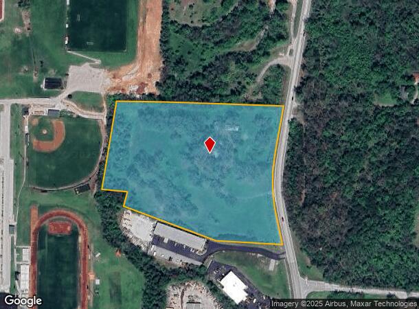
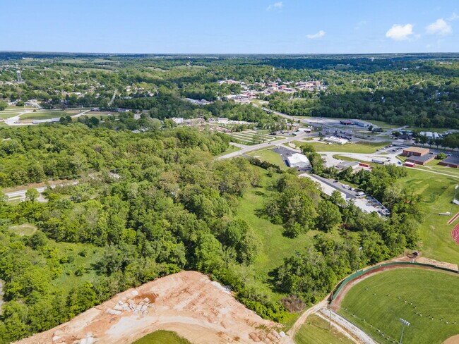
This Property Is For Sale
NEARBY LISTINGS FOR SALE OR LEASE
Property Detail
809 N 9Th St
11-0.5-22-001-005-001.000
Ozark, City Of In
Sfr
PT. SE1/4 NE1/4. BEG POINT 401 E OF NWC OF SE1/4 OF NEP. SE395, E 81, SW 90, SE 462.22, E 278.5TH W LINE OF HGY. NN, TH N ALONG R/W TO N LINE OF SAID SE4 NE4, TH W ALONE SAID LINE TO POB.
AE
Christian
29043C0089D
Missouri
2024
9.58 AC
2025
East Christian County
020309
Springfield
2,666 SF
Springfield, MO
DEMOGRAPHICS near 809 N 9Th St
1 mile
3 mile
5 mile
2024 Total Population
4,386
27,865
55,544
2029 Population
5,245
33,467
66,730
Pop Growth 2024-2029
+ 19.59%
+ 20.10%
+ 20.14%
Average Age
39
38
39
2024 Total Households
1,588
10,262
20,777
HH Growth 2024-2029
+ 19.84%
+ 20.23%
+ 20.21%
Median Household Inc
$74,492
$70,895
$74,442
Avg Household Size
2.60
2.60
2.60
2024 Avg HH Vehicles
2.00
2.00
2.00
Median Home Value
$187,556
$206,956
$233,963
Median Year Built
1995
1999
2000
Nearby Places
Map Layers
Map Styles
 Street
 Aerial
Transit
 Traffic
 Biking
Places
Listings with unknown addresses are not visible on the map
- Restaurants
- Banks
- Shops
- Fitness
- Groceries
PUBLIC TRANSPORTATION
AIRPORT
Springfield-Branson Ntl
Drive
Walk
Distance
Springfield-Branson Ntl
44 min
30.1 mi
Nearby Properties
Address
Land Use
TOTAL SIZE
Lot Size
Zoning
Address
Land Use
TOTAL SIZE
Lot Size
Zoning
13,048 SF
9.29 AC
Address
Land Use
TOTAL SIZE
Lot Size
Zoning
6,000 SF
50.60 AC
Address
Land Use
TOTAL SIZE
Lot Size
Zoning
129,257 SF
32 AC
Address
Land Use
TOTAL SIZE
Lot Size
Zoning
2,942 SF
17.41 AC
Address
Land Use
TOTAL SIZE
Lot Size
Zoning
33,019 SF
6.24 AC
Address
Land Use
TOTAL SIZE
Lot Size
Zoning
1,588 SF
73.78 AC
Address
Land Use
TOTAL SIZE
Lot Size
Zoning
3,942 SF
40 AC
Address
Land Use
TOTAL SIZE
Lot Size
Zoning
131,905 SF
17.94 AC
Address
Land Use
TOTAL SIZE
Lot Size
Zoning
3,025 SF
2.20 AC
Address
Land Use
TOTAL SIZE
Lot Size
Zoning
968 SF
18.67 AC
Address
Land Use
TOTAL SIZE
Lot Size
Zoning
4,800 SF
10.57 AC
Address
Land Use
TOTAL SIZE
Lot Size
Zoning
2,100 SF
20 AC
Address
Land Use
TOTAL SIZE
Lot Size
Zoning
77,079 SF
28.40 AC
Address
Land Use
TOTAL SIZE
Lot Size
Zoning
48,227 SF
3.07 AC
Address
Land Use
TOTAL SIZE
Lot Size
Zoning
7,472 SF
4.51 AC
Address
Land Use
TOTAL SIZE
Lot Size
Zoning
53,125 SF
8.01 AC
Address
Land Use
TOTAL SIZE
Lot Size
Zoning
38,524 SF
6.54 AC
Address
Land Use
TOTAL SIZE
Lot Size
Zoning
13,634 SF
3.51 AC
Address
Land Use
TOTAL SIZE
Lot Size
Zoning
5,824 SF
6.68 AC
Address
Land Use
TOTAL SIZE
Lot Size
Zoning
41,000 SF
4.50 AC
Address
Land Use
TOTAL SIZE
Lot Size
Zoning
23,625 SF
7.98 AC
Address
Land Use
TOTAL SIZE
Lot Size
Zoning
Address
Land Use
TOTAL SIZE
Lot Size
Zoning
3,003 SF
6.46 AC
Address
Land Use
TOTAL SIZE
Lot Size
Zoning
20,765 SF
3 AC
Address
Land Use
TOTAL SIZE
Lot Size
Zoning
8,802 SF
5.26 AC
Address
Land Use
TOTAL SIZE
Lot Size
Zoning
5,760 SF
8.62 AC
Address
Land Use
TOTAL SIZE
Lot Size
Zoning
Address
Land Use
TOTAL SIZE
Lot Size
Zoning
23,112 SF
0.54 AC
Address
Land Use
TOTAL SIZE
Lot Size
Zoning
3,464 SF
13.34 AC
Address
Land Use
TOTAL SIZE
Lot Size
Zoning
28,000 SF
3.62 AC
The World's #1 Commercial Real Estate Marketplace
Connect with us
© 2026 CoStar Group
The information above has been obtained from sources believed reliable. While we do not doubt its accuracy we have not verified it and make no guarantee, warranty or representation about it. It is your responsibility to independently confirm its accuracy and completeness. Any projections, opinions, assumptions, or estimates used are for example only and do not represent the current or future performance of the property. The value of this transaction to you depends on tax and other factors which should be evaluated by your tax, financial, and legal advisors. You and your advisors should conduct a careful, independent investigation of the property to determine to your satisfaction the suitability of the property for your needs.