Property Record
809 Pendleton St, Alexandria, VA 22314


Property Detail
809 Pendleton St
054.04-13-22
LOTS 35 & 36 BLK 1 SQUARE COLUMBUS ALFRED WYTHE & PENDLETON STS
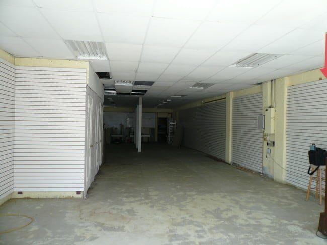
Restaurantbuilding
Alexandria City
CL
Virginia
B and X Area of moderate flood hazard, usually the area between the limits of the 100-year and 500-year floods.
35&36
2024
0.08 AC
2025
Old Town Alexandria
201805
Washington, DC
3,425 SF
Washington-Arlington-Alexandria, DC-VA-MD-WV
NEARBY LISTINGS FOR SALE OR LEASE
DEMOGRAPHICS near 809 Pendleton St
1 mile
3 mile
5 mile
2025 Total Population
30,398
159,062
486,948
2030 Population
31,339
164,469
504,482
Pop Growth 2025-2030
+ 3.10%
+ 3.40%
+ 3.60%
Average Age
42
39
39
2025 Total Households
15,814
73,298
217,109
HH Growth 2025-2030
+ 3.21%
+ 3.63%
+ 3.94%
Median Household Inc
$157,899
$121,960
$104,225
Avg Household Size
1.90
2.10
2.20
2025 Avg HH Vehicles
1.00
1.00
1.00
Median Home Value
$937,992
$760,242
$612,454
Median Year Built
1974
1972
1973
Nearby Places
Map Layers
Map Styles
 Street
 Aerial
Layers
 Traffic
 Biking
Places
Listings with unknown addresses are not visible on the map
- Restaurants
- Banks
- Shops
- Fitness
- Groceries
PUBLIC TRANSPORTATION
TRANSIT/SUBWAY
Braddock Road (Blue Line - Washington Metropolitan Area Transit Authority Metrorail (Metrorail), Yellow Line - Washington Metropolitan Area Transit Authority Metrorail (Metrorail))
Drive
Walk
Distance
Braddock Road (Blue Line - Washington Metropolitan Area Transit Authority Metrorail (Metrorail), Yellow Line - Washington Metropolitan Area Transit Authority Metrorail (Metrorail))
2 min
10 min
0.5 mi
King Street (Blue Line - Washington Metropolitan Area Transit Authority Metrorail (Metrorail), Yellow Line - Washington Metropolitan Area Transit Authority Metrorail (Metrorail))
Drive
Walk
Distance
King Street (Blue Line - Washington Metropolitan Area Transit Authority Metrorail (Metrorail), Yellow Line - Washington Metropolitan Area Transit Authority Metrorail (Metrorail))
3 min
19 min
1.0 mi
COMMUTER RAIL
Drive
Walk
Distance
4 min
1.2 mi
Alexandria (Fredericksburg Line - Virginia Railway Express, Manassas Line - Virginia Railway Express)
Drive
Walk
Distance
Alexandria (Fredericksburg Line - Virginia Railway Express, Manassas Line - Virginia Railway Express)
4 min
1.2 mi
AIRPORT
Ronald Reagan Washington Ntl
Drive
Walk
Distance
Ronald Reagan Washington Ntl
12 min
3.8 mi
Washington Dulles International
Drive
Walk
Distance
Washington Dulles International
53 min
31.2 mi
Baltimore/Washington International Thurgood Marshall
Drive
Walk
Distance
Baltimore/Washington International Thurgood Marshall
61 min
38.1 mi
Freight Ports
Port of Baltimore
Drive
Walk
Distance
Port of Baltimore
69 min
44.4 mi
SALE & LEASE HISTORY
LISTING DATE
SALE/LEASE

Jun 28, 2017
For Sale
Nearby Properties
Address
Land Use
TOTAL SIZE
Lot Size
Zoning
Address
Land Use
TOTAL SIZE
Lot Size
Zoning
900,000 SF
11.10 AC
S-3A
Address
Land Use
TOTAL SIZE
Lot Size
Zoning
1,241,298 SF
11.53 AC
RTOLE
Address
Land Use
TOTAL SIZE
Lot Size
Zoning
2,308,874 SF
22.78 AC
RR
Address
Land Use
TOTAL SIZE
Lot Size
Zoning
1,719,751 SF
39.48 AC
PDR-3;UNZO
Address
Land Use
TOTAL SIZE
Lot Size
Zoning
989,384 SF
5.17 AC
CDD#2
Address
Land Use
TOTAL SIZE
Lot Size
Zoning
1,931,127 SF
11.53 AC
RTOLE
Address
Land Use
TOTAL SIZE
Lot Size
Zoning
1,278,930 SF
28.17 AC
350
Address
Land Use
TOTAL SIZE
Lot Size
Zoning
6,370 SF
3.06 AC
RA6-15
Address
Land Use
TOTAL SIZE
Lot Size
Zoning
35.71 AC
P-S/RA8-18
Address
Land Use
TOTAL SIZE
Lot Size
Zoning
360,007 SF
35.80 AC
UT
Address
Land Use
TOTAL SIZE
Lot Size
Zoning
336,904 SF
2.12 AC
CDD#15
Address
Land Use
TOTAL SIZE
Lot Size
Zoning
1,032,882 SF
CDD#20
Address
Land Use
TOTAL SIZE
Lot Size
Zoning
53,549 SF
3.50 AC
C-O
Address
Land Use
TOTAL SIZE
Lot Size
Zoning
16,782 SF
1.67 AC
C-O-1.5
Address
Land Use
TOTAL SIZE
Lot Size
Zoning
568,512 SF
2 AC
C-O
Address
Land Use
TOTAL SIZE
Lot Size
Zoning
608,495 SF
1.50 AC
CDD#2
Address
Land Use
TOTAL SIZE
Lot Size
Zoning
2 SF
2.03 AC
C-O-1.5
Address
Land Use
TOTAL SIZE
Lot Size
Zoning
1,178,900 SF
4.67 AC
CDD#1
Address
Land Use
TOTAL SIZE
Lot Size
Zoning
343,400 SF
12 AC
POS
Address
Land Use
TOTAL SIZE
Lot Size
Zoning
514,822 SF
44.64 AC
Address
Land Use
TOTAL SIZE
Lot Size
Zoning
559,357 SF
2.26 AC
CDD#2
Address
Land Use
TOTAL SIZE
Lot Size
Zoning
981,001 SF
2.24 AC
C-O
Address
Land Use
TOTAL SIZE
Lot Size
Zoning
4,143 SF
1.89 AC
C-O-1.5
Address
Land Use
TOTAL SIZE
Lot Size
Zoning
395,900 SF
4.38 AC
C-O-1.5
Address
Land Use
TOTAL SIZE
Lot Size
Zoning
499,532 SF
3.04 AC
Address
Land Use
TOTAL SIZE
Lot Size
Zoning
694,318 SF
12.83 AC
CDD#7
Address
Land Use
TOTAL SIZE
Lot Size
Zoning
445,727 SF
12.82 AC
RC
Address
Land Use
TOTAL SIZE
Lot Size
Zoning
427,898 SF
1.88 AC
CDD#10
Address
Land Use
TOTAL SIZE
Lot Size
Zoning
166,800 SF
2.72 AC
CDD#1
Address
Land Use
TOTAL SIZE
Lot Size
Zoning
315,876 SF
1.55 AC
OCH
The World's #1 Commercial Real Estate Marketplace
Connect with us
© 2026 CoStar Group
The information above has been obtained from sources believed reliable. While we do not doubt its accuracy we have not verified it and make no guarantee, warranty or representation about it. It is your responsibility to independently confirm its accuracy and completeness. Any projections, opinions, assumptions, or estimates used are for example only and do not represent the current or future performance of the property. The value of this transaction to you depends on tax and other factors which should be evaluated by your tax, financial, and legal advisors. You and your advisors should conduct a careful, independent investigation of the property to determine to your satisfaction the suitability of the property for your needs.