Property Record
809 Podva Rd, Danville, CA 94526
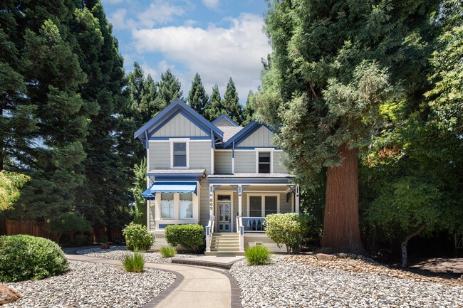


Property Detail
809 Podva Rd
208-462-013-3
POR RO SAN RAMON
Officebuilding
CONTRA COSTA
B and X Area of moderate flood hazard, usually the area between the limits of the 100-year and 500-year floods.
California
2025
0.45 AC
2025
Danville/Alamo
345203
East Bay/Oakland
3,064 SF
Oakland-Fremont-Berkeley, CA
NEARBY LISTINGS FOR SALE OR LEASE
DEMOGRAPHICS near 809 Podva Rd
1 mile
3 mile
5 mile
2025 Total Population
7,772
48,659
109,017
2030 Population
7,900
49,064
109,606
Pop Growth 2025-2030
+ 1.65%
+ 0.83%
+ 0.54%
Average Age
44
44
44
2025 Total Households
3,029
17,970
39,917
HH Growth 2025-2030
+ 1.88%
+ 0.93%
+ 0.61%
Median Household Inc
$211,567
$207,324
$202,655
Avg Household Size
2.50
2.70
2.70
2025 Avg HH Vehicles
2.00
2.00
2.00
Median Home Value
$1,119,869
$1,120,708
$1,116,675
Median Year Built
1976
1977
1983
Nearby Places
Map Layers
Map Styles
 Street
 Aerial
Transit
 Traffic
 Biking
Places
Listings with unknown addresses are not visible on the map
- Restaurants
- Banks
- Shops
- Fitness
- Groceries
PUBLIC TRANSPORTATION
AIRPORT
Metro Oakland International
Drive
Walk
Distance
Metro Oakland International
35 min
27.4 mi
San Francisco International
Drive
Walk
Distance
San Francisco International
55 min
36.6 mi
Norman Y Mineta San Jose International
Drive
Walk
Distance
Norman Y Mineta San Jose International
47 min
38.2 mi
Freight Ports
Port of Oakland
Drive
Walk
Distance
Port of Oakland
32 min
23.7 mi
SALE & LEASE HISTORY
LISTING DATE
SALE/LEASE

Jul 19, 2022
For Sale
Nearby Properties
Address
Land Use
TOTAL SIZE
Lot Size
Zoning
Address
Land Use
TOTAL SIZE
Lot Size
Zoning
157,729 SF
4.26 AC
Address
Land Use
TOTAL SIZE
Lot Size
Zoning
Address
Land Use
TOTAL SIZE
Lot Size
Zoning
80,368 SF
5.89 AC
Address
Land Use
TOTAL SIZE
Lot Size
Zoning
254,640 SF
13.29 AC
Address
Land Use
TOTAL SIZE
Lot Size
Zoning
147,509 SF
73.78 AC
A2
Address
Land Use
TOTAL SIZE
Lot Size
Zoning
2,996 SF
4.40 AC
Address
Land Use
TOTAL SIZE
Lot Size
Zoning
96,882 SF
5.82 AC
Address
Land Use
TOTAL SIZE
Lot Size
Zoning
156,750 SF
16.50 AC
Address
Land Use
TOTAL SIZE
Lot Size
Zoning
Address
Land Use
TOTAL SIZE
Lot Size
Zoning
140,428 SF
9.98 AC
Address
Land Use
TOTAL SIZE
Lot Size
Zoning
5,414 SF
4.73 AC
Address
Land Use
TOTAL SIZE
Lot Size
Zoning
323,340 SF
3.42 AC
Address
Land Use
TOTAL SIZE
Lot Size
Zoning
50,412 SF
3.20 AC
Address
Land Use
TOTAL SIZE
Lot Size
Zoning
97,123 SF
7.35 AC
Address
Land Use
TOTAL SIZE
Lot Size
Zoning
106,840 SF
11.96 AC
Address
Land Use
TOTAL SIZE
Lot Size
Zoning
80,590 SF
2.94 AC
Address
Land Use
TOTAL SIZE
Lot Size
Zoning
67,642 SF
3.89 AC
Address
Land Use
TOTAL SIZE
Lot Size
Zoning
139,308 SF
4.86 AC
Address
Land Use
TOTAL SIZE
Lot Size
Zoning
38,199 SF
9.56 AC
Address
Land Use
TOTAL SIZE
Lot Size
Zoning
81,011 SF
4.64 AC
Address
Land Use
TOTAL SIZE
Lot Size
Zoning
78,272 SF
13.70 AC
Address
Land Use
TOTAL SIZE
Lot Size
Zoning
47,667 SF
2.78 AC
Address
Land Use
TOTAL SIZE
Lot Size
Zoning
146,063 SF
11.09 AC
Address
Land Use
TOTAL SIZE
Lot Size
Zoning
Address
Land Use
TOTAL SIZE
Lot Size
Zoning
154,250 SF
7.14 AC
Address
Land Use
TOTAL SIZE
Lot Size
Zoning
86,168 SF
5.24 AC
Address
Land Use
TOTAL SIZE
Lot Size
Zoning
74,393 SF
5.67 AC
Address
Land Use
TOTAL SIZE
Lot Size
Zoning
73,276 SF
3.73 AC
Address
Land Use
TOTAL SIZE
Lot Size
Zoning
6.03 AC
Address
Land Use
TOTAL SIZE
Lot Size
Zoning
51,462 SF
2 AC
The World's #1 Commercial Real Estate Marketplace
Connect with us
© 2026 CoStar Group
The information above has been obtained from sources believed reliable. While we do not doubt its accuracy we have not verified it and make no guarantee, warranty or representation about it. It is your responsibility to independently confirm its accuracy and completeness. Any projections, opinions, assumptions, or estimates used are for example only and do not represent the current or future performance of the property. The value of this transaction to you depends on tax and other factors which should be evaluated by your tax, financial, and legal advisors. You and your advisors should conduct a careful, independent investigation of the property to determine to your satisfaction the suitability of the property for your needs.