Property Record
809 Sabattus St, Lewiston, ME 04240
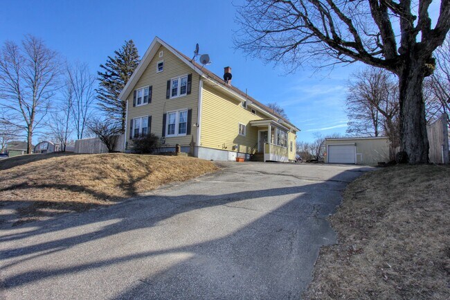

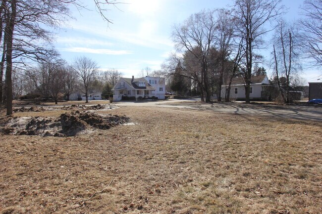
Property Detail
809 Sabattus St
LEWI-000119-000000-000209
Androscoggin
Apartment
Maine
B and X Area of moderate flood hazard, usually the area between the limits of the 100-year and 500-year floods.
209
2025
0.25 AC
2025
Maine South & Augusta
020802
Other Market Areas
5,082 SF
Lewiston-Auburn, ME
NEARBY LISTINGS FOR SALE OR LEASE
-
-
View all Lewiston listings for sale on LoopNet.com
DEMOGRAPHICS near 809 Sabattus St
1 mile
3 mile
5 mile
2025 Total Population
6,165
46,967
63,849
2030 Population
6,180
48,081
65,296
Pop Growth 2025-2030
+ 0.24%
+ 2.37%
+ 2.27%
Average Age
43
39
41
2025 Total Households
2,677
19,119
25,876
HH Growth 2025-2030
+ 0.56%
+ 2.33%
+ 2.28%
Median Household Inc
$74,825
$50,236
$56,635
Avg Household Size
2.20
2.20
2.20
2025 Avg HH Vehicles
2.00
1.00
2.00
Median Home Value
$244,493
$240,084
$248,288
Median Year Built
1965
1954
1955
Nearby Places
Map Layers
Map Styles
 Street
 Aerial
Layers
 Traffic
 Biking
Places
Listings with unknown addresses are not visible on the map
- Restaurants
- Banks
- Shops
- Fitness
- Groceries
PUBLIC TRANSPORTATION
AIRPORT
Portland International Jetport
Drive
Walk
Distance
Portland International Jetport
51 min
38.8 mi
SALE & LEASE HISTORY
LISTING DATE
SALE/LEASE

Mar 23, 2020
For Sale
Mar 08, 2023
For Sale
Nearby Properties
Address
Land Use
TOTAL SIZE
Lot Size
Zoning
Address
Land Use
TOTAL SIZE
Lot Size
Zoning
542,760 SF
8.12 AC
Address
Land Use
TOTAL SIZE
Lot Size
Zoning
1,728 SF
53.55 AC
Address
Land Use
TOTAL SIZE
Lot Size
Zoning
Address
Land Use
TOTAL SIZE
Lot Size
Zoning
7.76 AC
Address
Land Use
TOTAL SIZE
Lot Size
Zoning
Address
Land Use
TOTAL SIZE
Lot Size
Zoning
50,000 SF
86.08 AC
Address
Land Use
TOTAL SIZE
Lot Size
Zoning
1.53 AC
Address
Land Use
TOTAL SIZE
Lot Size
Zoning
49,842 SF
23 AC
Address
Land Use
TOTAL SIZE
Lot Size
Zoning
144,650 SF
16.19 AC
Address
Land Use
TOTAL SIZE
Lot Size
Zoning
67,873 SF
Address
Land Use
TOTAL SIZE
Lot Size
Zoning
106,600 SF
0.73 AC
Address
Land Use
TOTAL SIZE
Lot Size
Zoning
93,343 SF
16.41 AC
Address
Land Use
TOTAL SIZE
Lot Size
Zoning
127,660 SF
9.24 AC
Address
Land Use
TOTAL SIZE
Lot Size
Zoning
27,606 SF
1.10 AC
Address
Land Use
TOTAL SIZE
Lot Size
Zoning
90,085 SF
1.49 AC
Address
Land Use
TOTAL SIZE
Lot Size
Zoning
Address
Land Use
TOTAL SIZE
Lot Size
Zoning
144,665 SF
36.25 AC
Address
Land Use
TOTAL SIZE
Lot Size
Zoning
210,388 SF
1.46 AC
Address
Land Use
TOTAL SIZE
Lot Size
Zoning
125,449 SF
Address
Land Use
TOTAL SIZE
Lot Size
Zoning
94,914 SF
Address
Land Use
TOTAL SIZE
Lot Size
Zoning
76,915 SF
1.83 AC
Address
Land Use
TOTAL SIZE
Lot Size
Zoning
155,140 SF
26.55 AC
Address
Land Use
TOTAL SIZE
Lot Size
Zoning
60,728 SF
0.86 AC
Address
Land Use
TOTAL SIZE
Lot Size
Zoning
136,901 SF
10.50 AC
Address
Land Use
TOTAL SIZE
Lot Size
Zoning
7.22 AC
Address
Land Use
TOTAL SIZE
Lot Size
Zoning
93.04 AC
Address
Land Use
TOTAL SIZE
Lot Size
Zoning
47,969 SF
9.48 AC
Address
Land Use
TOTAL SIZE
Lot Size
Zoning
49,638 SF
0.76 AC
Address
Land Use
TOTAL SIZE
Lot Size
Zoning
96,073 SF
Address
Land Use
TOTAL SIZE
Lot Size
Zoning
110,728 SF
10.77 AC
The World's #1 Commercial Real Estate Marketplace
Connect with us
© 2026 CoStar Group
The information above has been obtained from sources believed reliable. While we do not doubt its accuracy we have not verified it and make no guarantee, warranty or representation about it. It is your responsibility to independently confirm its accuracy and completeness. Any projections, opinions, assumptions, or estimates used are for example only and do not represent the current or future performance of the property. The value of this transaction to you depends on tax and other factors which should be evaluated by your tax, financial, and legal advisors. You and your advisors should conduct a careful, independent investigation of the property to determine to your satisfaction the suitability of the property for your needs.