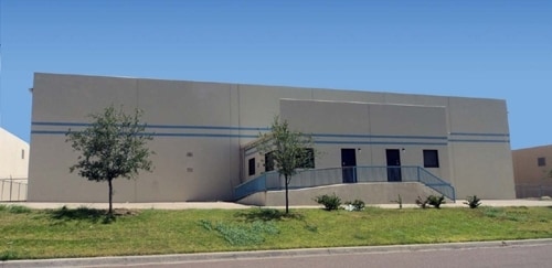
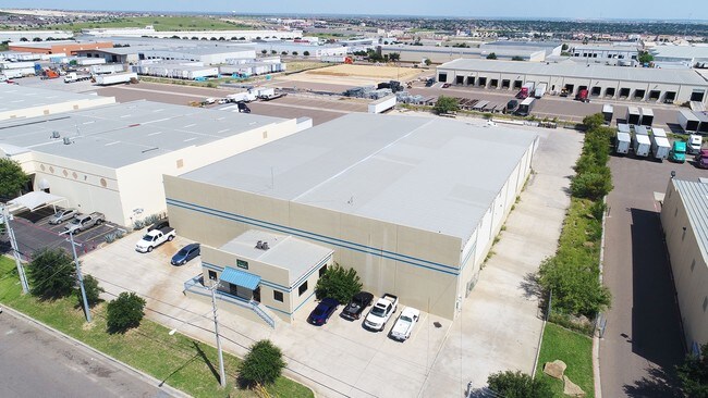
Property Record
809 Union Pacific Blvd, Laredo, TX 78045

Property Detail
809 Union Pacific Blvd
256089
SAN ISIDRO RANCH EAST POINT CTR, BLOCK 5, LOT 20, UNIT 2
Commercialnec
Webb
M1
Texas
B and X Area of moderate flood hazard, usually the area between the limits of the 100-year and 500-year floods.
20
2024
1.84 AC
2025
Other Market Areas
001726
Laredo, TX
27,600 SF
NEARBY LISTINGS FOR SALE OR LEASE
DEMOGRAPHICS near 809 Union Pacific Blvd
1 mile
3 mile
5 mile
2024 Total Population
2,529
41,148
92,036
2029 Population
2,621
42,192
94,242
Pop Growth 2024-2029
+ 3.64%
+ 2.54%
+ 2.40%
Average Age
33
35
35
2024 Total Households
779
12,746
28,205
HH Growth 2024-2029
+ 3.85%
+ 2.76%
+ 2.61%
Median Household Inc
$79,200
$89,238
$84,490
Avg Household Size
3.30
3.20
3.20
2024 Avg HH Vehicles
2.00
2.00
2.00
Median Home Value
$287,254
$278,277
$265,924
Median Year Built
2005
2004
2002
Nearby Places
Map Layers
Map Styles
 Street
 Aerial
Transit
 Traffic
 Biking
Places
Listings with unknown addresses are not visible on the map
- Restaurants
- Banks
- Shops
- Fitness
- Groceries
SALE & LEASE HISTORY
LISTING DATE
SALE/LEASE

Aug 14, 2017
For Lease
Aug 08, 2019
For Lease
Nearby Properties
Address
Land Use
TOTAL SIZE
Lot Size
Zoning
Address
Land Use
TOTAL SIZE
Lot Size
Zoning
430,587 SF
30 AC
R1
Address
Land Use
TOTAL SIZE
Lot Size
Zoning
251,512 SF
57.32 AC
B4
Address
Land Use
TOTAL SIZE
Lot Size
Zoning
255,819 SF
50 AC
R1
Address
Land Use
TOTAL SIZE
Lot Size
Zoning
436,814 SF
27.66 AC
Address
Land Use
TOTAL SIZE
Lot Size
Zoning
206,224 SF
20.03 AC
R1
Address
Land Use
TOTAL SIZE
Lot Size
Zoning
649,220 SF
38.29 AC
M1
Address
Land Use
TOTAL SIZE
Lot Size
Zoning
562,944 SF
30 AC
M1
Address
Land Use
TOTAL SIZE
Lot Size
Zoning
370,800 SF
40.09 AC
Address
Land Use
TOTAL SIZE
Lot Size
Zoning
521,026 SF
30 AC
M1
Address
Land Use
TOTAL SIZE
Lot Size
Zoning
286,008 SF
37.30 AC
Address
Land Use
TOTAL SIZE
Lot Size
Zoning
109,695 SF
3.73 AC
M1
Address
Land Use
TOTAL SIZE
Lot Size
Zoning
194,520 SF
11.18 AC
B3
Address
Land Use
TOTAL SIZE
Lot Size
Zoning
254,594 SF
11.84 AC
Address
Land Use
TOTAL SIZE
Lot Size
Zoning
192,203 SF
22.01 AC
B4
Address
Land Use
TOTAL SIZE
Lot Size
Zoning
136,981 SF
10.01 AC
Address
Land Use
TOTAL SIZE
Lot Size
Zoning
170,632 SF
8.03 AC
B3
Address
Land Use
TOTAL SIZE
Lot Size
Zoning
101,034 SF
19.79 AC
Address
Land Use
TOTAL SIZE
Lot Size
Zoning
243,399 SF
15.50 AC
Address
Land Use
TOTAL SIZE
Lot Size
Zoning
246,003 SF
24.32 AC
Address
Land Use
TOTAL SIZE
Lot Size
Zoning
100,598 SF
26.22 AC
Address
Land Use
TOTAL SIZE
Lot Size
Zoning
95,769 SF
11.81 AC
Address
Land Use
TOTAL SIZE
Lot Size
Zoning
228,046 SF
13.58 AC
Address
Land Use
TOTAL SIZE
Lot Size
Zoning
93,707 SF
12.29 AC
Address
Land Use
TOTAL SIZE
Lot Size
Zoning
253,180 SF
16.56 AC
M1
Address
Land Use
TOTAL SIZE
Lot Size
Zoning
264,984 SF
18.70 AC
Address
Land Use
TOTAL SIZE
Lot Size
Zoning
200,446 SF
25.68 AC
M1
Address
Land Use
TOTAL SIZE
Lot Size
Zoning
95,769 SF
10 AC
AG
Address
Land Use
TOTAL SIZE
Lot Size
Zoning
120,103 SF
12.36 AC
B4
Address
Land Use
TOTAL SIZE
Lot Size
Zoning
95,769 SF
8.30 AC
R1
Address
Land Use
TOTAL SIZE
Lot Size
Zoning
70,453 SF
21.12 AC
AG
The World's #1 Commercial Real Estate Marketplace
Connect with us
© 2026 CoStar Group
The information above has been obtained from sources believed reliable. While we do not doubt its accuracy we have not verified it and make no guarantee, warranty or representation about it. It is your responsibility to independently confirm its accuracy and completeness. Any projections, opinions, assumptions, or estimates used are for example only and do not represent the current or future performance of the property. The value of this transaction to you depends on tax and other factors which should be evaluated by your tax, financial, and legal advisors. You and your advisors should conduct a careful, independent investigation of the property to determine to your satisfaction the suitability of the property for your needs.