Property Record
809 W Cedar St, Kalamazoo, MI 49007
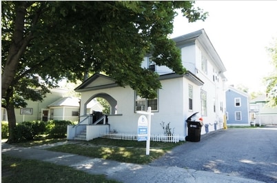

Property Detail
809 W Cedar St
06-21-235-434
50428 WELCHS ADDITION LOT 434.
Commercialnec
Kalamazoo
RM-15
Michigan
B and X Area of moderate flood hazard, usually the area between the limits of the 100-year and 500-year floods.
434
2025
0.20 AC
2025
Vine
000601
West Michigan
3,601 SF
Kalamazoo-Portage, MI
NEARBY LISTINGS FOR SALE OR LEASE
DEMOGRAPHICS near 809 W Cedar St
1 mile
3 mile
5 mile
2025 Total Population
19,917
98,624
157,782
2030 Population
21,560
102,017
160,911
Pop Growth 2025-2030
+ 8.25%
+ 3.44%
+ 1.98%
Average Age
33
34
36
2025 Total Households
8,862
40,889
66,636
HH Growth 2025-2030
+ 9.07%
+ 3.81%
+ 2.08%
Median Household Inc
$47,728
$49,579
$56,737
Avg Household Size
2.00
2.20
2.20
2025 Avg HH Vehicles
2.00
2.00
2.00
Median Home Value
$168,467
$178,169
$199,083
Median Year Built
1963
1967
1972
Nearby Places
Map Layers
Map Styles
 Street
 Aerial
Layers
 Traffic
 Biking
Places
Listings with unknown addresses are not visible on the map
- Restaurants
- Banks
- Shops
- Fitness
- Groceries
PUBLIC TRANSPORTATION
COMMUTER RAIL
Drive
Walk
Distance
4 min
20 min
1.0 mi
AIRPORT
Kalamazoo/Battle Creek International
Drive
Walk
Distance
Kalamazoo/Battle Creek International
16 min
5.8 mi
SALE & LEASE HISTORY
LISTING DATE
SALE/LEASE

Nov 16, 2017
For Sale
Nearby Properties
Address
Land Use
TOTAL SIZE
Lot Size
Zoning
Address
Land Use
TOTAL SIZE
Lot Size
Zoning
632,218 SF
10.84 AC
M-1
Address
Land Use
TOTAL SIZE
Lot Size
Zoning
374,906 SF
16.31 AC
RM-36
Address
Land Use
TOTAL SIZE
Lot Size
Zoning
289,865 SF
23.60 AC
PUD
Address
Land Use
TOTAL SIZE
Lot Size
Zoning
35,870 SF
12.78 AC
CC
Address
Land Use
TOTAL SIZE
Lot Size
Zoning
331,571 SF
19.68 AC
RM-15
Address
Land Use
TOTAL SIZE
Lot Size
Zoning
329,276 SF
43.86 AC
RM-1
Address
Land Use
TOTAL SIZE
Lot Size
Zoning
429,500 SF
2 AC
CCBD
Address
Land Use
TOTAL SIZE
Lot Size
Zoning
315,422 SF
25.40 AC
RM-15
Address
Land Use
TOTAL SIZE
Lot Size
Zoning
877,422 SF
38.18 AC
M-2
Address
Land Use
TOTAL SIZE
Lot Size
Zoning
14,095 SF
27.05 AC
PUD
Address
Land Use
TOTAL SIZE
Lot Size
Zoning
186,073 SF
28.64 AC
C COMM
Address
Land Use
TOTAL SIZE
Lot Size
Zoning
291,495 SF
18.39 AC
PUD
Address
Land Use
TOTAL SIZE
Lot Size
Zoning
105,046 SF
19.30 AC
RM-15
Address
Land Use
TOTAL SIZE
Lot Size
Zoning
273,122 SF
16.12 AC
PUD
Address
Land Use
TOTAL SIZE
Lot Size
Zoning
201,940 SF
9.30 AC
RM-36
Address
Land Use
TOTAL SIZE
Lot Size
Zoning
255,452 SF
20.57 AC
Address
Land Use
TOTAL SIZE
Lot Size
Zoning
230,820 SF
16.50 AC
R-4 MUL
Address
Land Use
TOTAL SIZE
Lot Size
Zoning
110,686 SF
9.45 AC
CCBD
Address
Land Use
TOTAL SIZE
Lot Size
Zoning
134,876 SF
16.45 AC
RM-15
Address
Land Use
TOTAL SIZE
Lot Size
Zoning
275,595 SF
0.65 AC
CCBD
Address
Land Use
TOTAL SIZE
Lot Size
Zoning
Address
Land Use
TOTAL SIZE
Lot Size
Zoning
50,826 SF
0.79 AC
CCBD
Address
Land Use
TOTAL SIZE
Lot Size
Zoning
186,652 SF
28.29 AC
PUD
Address
Land Use
TOTAL SIZE
Lot Size
Zoning
228,368 SF
9.60 AC
PUD
Address
Land Use
TOTAL SIZE
Lot Size
Zoning
224,424 SF
18.89 AC
R-4 MUL
Address
Land Use
TOTAL SIZE
Lot Size
Zoning
274,412 SF
12.10 AC
RM-1
Address
Land Use
TOTAL SIZE
Lot Size
Zoning
179,628 SF
12.99 AC
RM-15
Address
Land Use
TOTAL SIZE
Lot Size
Zoning
178,882 SF
10.02 AC
RS-5
Address
Land Use
TOTAL SIZE
Lot Size
Zoning
99,092 SF
1.45 AC
CCBD
Address
Land Use
TOTAL SIZE
Lot Size
Zoning
136,001 SF
22.56 AC
C COMM
The World's #1 Commercial Real Estate Marketplace
Connect with us
© 2026 CoStar Group
The information above has been obtained from sources believed reliable. While we do not doubt its accuracy we have not verified it and make no guarantee, warranty or representation about it. It is your responsibility to independently confirm its accuracy and completeness. Any projections, opinions, assumptions, or estimates used are for example only and do not represent the current or future performance of the property. The value of this transaction to you depends on tax and other factors which should be evaluated by your tax, financial, and legal advisors. You and your advisors should conduct a careful, independent investigation of the property to determine to your satisfaction the suitability of the property for your needs.