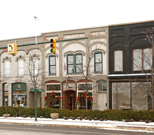
Property Record
8093 Main St, Dexter, MI 48130

NEARBY LISTINGS FOR SALE OR LEASE
Property Detail
8093 Main St
Ann Arbor, MI
Original - Dexter Village
08-06-210-039
COM AT NE'LY COR OF LOT 1, BLK 19, TH N 63-19-25 W 52.08 FT FOR A POB, TH S 23-32-18 W 62.94 FT, TH N 62-56-39 W 0.77 FT, TH
Commercialnec
Washtenaw
X
Michigan
26161C0209E
1
2025
0.08 AC
2025
Washtenaw W of 23
454002
Detroit
3,620 SF
DEMOGRAPHICS near 8093 Main St
1 Mile
3 Mile
5 Mile
2024 Total Population
3,994
9,832
24,798
2029 Population
3,989
9,754
24,527
Pop Growth 2024-2029
(0.13%)
(0.79%)
(1.09%)
Average Age
41
42
42
2024 Total Households
1,571
3,712
9,300
HH Growth 2024-2029
(0.25%)
(0.94%)
(1.18%)
Median Household Inc
$93,571
$111,919
$118,411
Avg Household Size
2.50
2.60
2.60
2024 Avg HH Vehicles
2.00
2.00
2.00
Median Home Value
$381,745
$396,587
$417,917
Median Year Built
1992
1992
1992
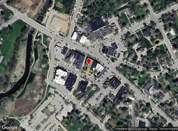
Nearby Places
Map Layers
Map Styles
 Street
 Aerial
- Restaurants
- Banks
- Shops
- Fitness
- Groceries
PUBLIC TRANSPORTATION
COMMUTER RAIL
DRIVE
WALK
Distance
18 min
9.0 mi
AIRPORT
Detroit Metro Wayne County
DRIVE
WALK
Distance
Detroit Metro Wayne County
48 min
37.6 mi
Freight Ports
DRIVE
WALK
Distance
87 min
69.0 mi
Nearby Properties
Address
Land Use
TOTAL SIZE
Lot Size
Zoning
Address
Land Use
TOTAL SIZE
Lot Size
Zoning
460,082 SF
42.24 AC
RD
Address
Land Use
TOTAL SIZE
Lot Size
Zoning
443,838 SF
47.01 AC
I-1
Address
Land Use
TOTAL SIZE
Lot Size
Zoning
24.06 AC
R-3
Address
Land Use
TOTAL SIZE
Lot Size
Zoning
2,913 SF
25.61 AC
C-3
Address
Land Use
TOTAL SIZE
Lot Size
Zoning
61,760 SF
18.06 AC
II
Address
Land Use
TOTAL SIZE
Lot Size
Zoning
52,990 SF
20.49 AC
I-1
Address
Land Use
TOTAL SIZE
Lot Size
Zoning
Address
Land Use
TOTAL SIZE
Lot Size
Zoning
13.36 AC
R-3
Address
Land Use
TOTAL SIZE
Lot Size
Zoning
Address
Land Use
TOTAL SIZE
Lot Size
Zoning
49,707 SF
4.50 AC
C-1
Address
Land Use
TOTAL SIZE
Lot Size
Zoning
31,970 SF
8.34 AC
C-1
Address
Land Use
TOTAL SIZE
Lot Size
Zoning
88,590 SF
9.80 AC
RD
Address
Land Use
TOTAL SIZE
Lot Size
Zoning
11.82 AC
SEVERAL
Address
Land Use
TOTAL SIZE
Lot Size
Zoning
150,000 SF
18.24 AC
I-1
Address
Land Use
TOTAL SIZE
Lot Size
Zoning
68,000 SF
11.61 AC
RD
Address
Land Use
TOTAL SIZE
Lot Size
Zoning
70,200 SF
8.06 AC
IRP
Address
Land Use
TOTAL SIZE
Lot Size
Zoning
84,460 SF
IFT PARCEL
Address
Land Use
TOTAL SIZE
Lot Size
Zoning
67,262 SF
9.05 AC
C-1
Address
Land Use
TOTAL SIZE
Lot Size
Zoning
4,788 SF
14.35 AC
SEVERAL
Address
Land Use
TOTAL SIZE
Lot Size
Zoning
43,293 SF
2.20 AC
RD
Address
Land Use
TOTAL SIZE
Lot Size
Zoning
15,444 SF
3.28 AC
PB
Address
Land Use
TOTAL SIZE
Lot Size
Zoning
576 SF
IFT PARCEL
Address
Land Use
TOTAL SIZE
Lot Size
Zoning
21,870 SF
0.46 AC
VILLAGE
Address
Land Use
TOTAL SIZE
Lot Size
Zoning
18,000 SF
6.68 AC
PUD
Address
Land Use
TOTAL SIZE
Lot Size
Zoning
10,530 SF
2 AC
PB
Address
Land Use
TOTAL SIZE
Lot Size
Zoning
73,803 SF
3.70 AC
RD
Address
Land Use
TOTAL SIZE
Lot Size
Zoning
7,890 SF
1.20 AC
VR
Address
Land Use
TOTAL SIZE
Lot Size
Zoning
21,312 SF
1.99 AC
PUD
Address
Land Use
TOTAL SIZE
Lot Size
Zoning
131,520 SF
6.62 AC
C-1
Address
Land Use
TOTAL SIZE
Lot Size
Zoning
62,900 SF
10.01 AC
RD
The World's #1 Commercial Real Estate Marketplace
Connect with us
© 2026 CoStar Group
The information above has been obtained from sources believed reliable. While we do not doubt its accuracy we have not verified it and make no guarantee, warranty or representation about it. It is your responsibility to independently confirm its accuracy and completeness. Any projections, opinions, assumptions, or estimates used are for example only and do not represent the current or future performance of the property. The value of this transaction to you depends on tax and other factors which should be evaluated by your tax, financial, and legal advisors. You and your advisors should conduct a careful, independent investigation of the property to determine to your satisfaction the suitability of the property for your needs.