Property Record
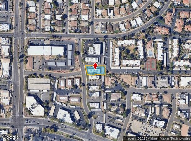
8095 N 85Th Way, Scottsdale, AZ 85258

NEARBY LISTINGS FOR SALE OR LEASE
Property Detail
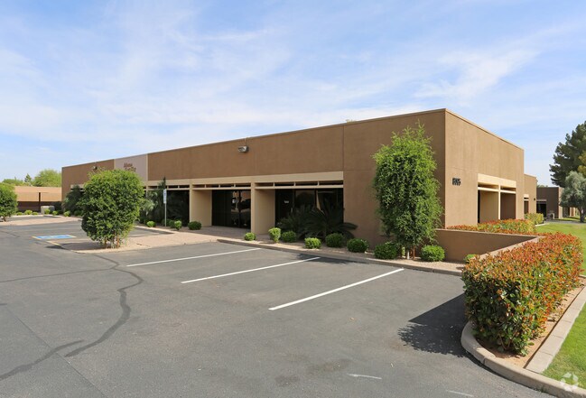
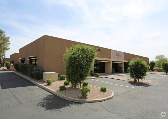
8095 N 85Th Way
Phoenix-Mesa-Scottsdale, AZ
Dobson Ranch Medical Dental Center
174-04-927
DOBSON RANCH MEDICAL DENTAL CENTER MCR 246-45
Officebuilding
Maricopa
X
Arizona
04013C1770M
5
2025
0.40 AC
2025
Central Scottsdale
216807
Phoenix
4,383 SF
DEMOGRAPHICS near 8095 N 85Th Way
1 Mile
3 Mile
5 Mile
2024 Total Population
9,500
62,097
164,399
2029 Population
10,485
68,225
180,916
Pop Growth 2024-2029
+ 10.37%
+ 9.87%
+ 10.05%
Average Age
48
48
46
2024 Total Households
4,632
30,180
78,598
HH Growth 2024-2029
+ 10.28%
+ 10.05%
+ 10.36%
Median Household Inc
$95,445
$101,003
$99,707
Avg Household Size
2.00
2.00
2.00
2024 Avg HH Vehicles
2.00
2.00
2.00
Median Home Value
$685,790
$686,398
$680,887
Median Year Built
1980
1984
1986
Nearby Places
Map Layers
Map Styles
 Street
 Aerial
- Restaurants
- Banks
- Shops
- Fitness
- Groceries
PUBLIC TRANSPORTATION
AIRPORT
Phoenix Sky Harbor International
DRIVE
WALK
Distance
Phoenix Sky Harbor International
24 min
16.1 mi
Phoenix-Mesa Gateway
DRIVE
WALK
Distance
Phoenix-Mesa Gateway
45 min
31.5 mi
SALE & LEASE HISTORY
LISTING DATE
SALE/LEASE

Jan 30, 2024
For Lease
Nearby Properties
Address
Land Use
TOTAL SIZE
Lot Size
Zoning
Address
Land Use
TOTAL SIZE
Lot Size
Zoning
500,010 SF
4.52 AC
PF
Address
Land Use
TOTAL SIZE
Lot Size
Zoning
367,367 SF
37.89 AC
R-43
Address
Land Use
TOTAL SIZE
Lot Size
Zoning
623,263 SF
27.34 AC
M-H
Address
Land Use
TOTAL SIZE
Lot Size
Zoning
440,573 SF
19.10 AC
SUPR
Address
Land Use
TOTAL SIZE
Lot Size
Zoning
380,106 SF
38.10 AC
C-T
Address
Land Use
TOTAL SIZE
Lot Size
Zoning
355,757 SF
32.44 AC
C-R
Address
Land Use
TOTAL SIZE
Lot Size
Zoning
457,979 SF
9.26 AC
CO
Address
Land Use
TOTAL SIZE
Lot Size
Zoning
734,506 SF
7.75 AC
C-T
Address
Land Use
TOTAL SIZE
Lot Size
Zoning
22,630 SF
1.06 AC
SUPP
Address
Land Use
TOTAL SIZE
Lot Size
Zoning
515,127 SF
7.57 AC
C-T
Address
Land Use
TOTAL SIZE
Lot Size
Zoning
289,633 SF
9.11 AC
R-10
Address
Land Use
TOTAL SIZE
Lot Size
Zoning
250,415 SF
21 AC
I-P
Address
Land Use
TOTAL SIZE
Lot Size
Zoning
355,399 SF
7.13 AC
C-C
Address
Land Use
TOTAL SIZE
Lot Size
Zoning
163,075 SF
17.77 AC
C-R
Address
Land Use
TOTAL SIZE
Lot Size
Zoning
353,691 SF
16.18 AC
M-H
Address
Land Use
TOTAL SIZE
Lot Size
Zoning
121,740 SF
22.13 AC
SUPR
Address
Land Use
TOTAL SIZE
Lot Size
Zoning
345,713 SF
18.25 AC
M-H
Address
Land Use
TOTAL SIZE
Lot Size
Zoning
138,984 SF
14.30 AC
C-C
Address
Land Use
TOTAL SIZE
Lot Size
Zoning
247,810 SF
29.27 AC
Address
Land Use
TOTAL SIZE
Lot Size
Zoning
20,355 SF
38.96 AC
M-H
Address
Land Use
TOTAL SIZE
Lot Size
Zoning
358,139 SF
5.31 AC
PUD
Address
Land Use
TOTAL SIZE
Lot Size
Zoning
270,059 SF
10.61 AC
M-H
Address
Land Use
TOTAL SIZE
Lot Size
Zoning
359,568 SF
19 AC
RT
Address
Land Use
TOTAL SIZE
Lot Size
Zoning
352,440 SF
17.51 AC
R-5
Address
Land Use
TOTAL SIZE
Lot Size
Zoning
240,248 SF
4.67 AC
C-T
Address
Land Use
TOTAL SIZE
Lot Size
Zoning
369,186 SF
12.45 AC
Address
Land Use
TOTAL SIZE
Lot Size
Zoning
360,143 SF
11.88 AC
C-C
Address
Land Use
TOTAL SIZE
Lot Size
Zoning
Address
Land Use
TOTAL SIZE
Lot Size
Zoning
168,456 SF
7.36 AC
R-7
Address
Land Use
TOTAL SIZE
Lot Size
Zoning
144,102 SF
18.45 AC
R-18
The World's #1 Commercial Real Estate Marketplace
Connect with us
© 2025 CoStar Group
The information above has been obtained from sources believed reliable. While we do not doubt its accuracy we have not verified it and make no guarantee, warranty or representation about it. It is your responsibility to independently confirm its accuracy and completeness. Any projections, opinions, assumptions, or estimates used are for example only and do not represent the current or future performance of the property. The value of this transaction to you depends on tax and other factors which should be evaluated by your tax, financial, and legal advisors. You and your advisors should conduct a careful, independent investigation of the property to determine to your satisfaction the suitability of the property for your needs.