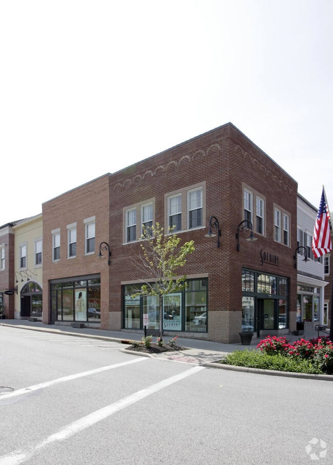
Property Record
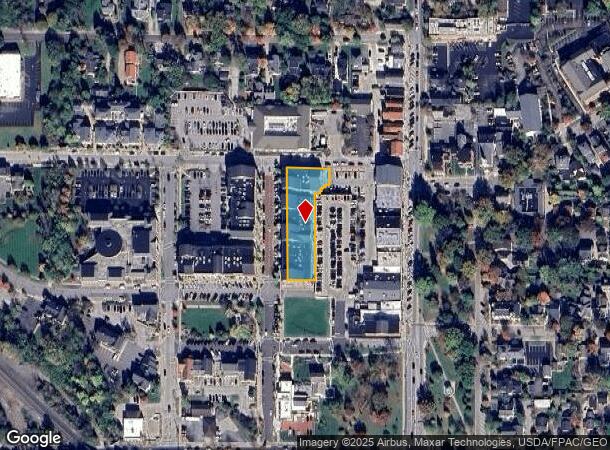
103 1St St, Hudson, OH 44236

NEARBY LISTINGS FOR SALE OR LEASE
Property Detail
103 1St St
Akron, OH
City Of Hudson Downtown Development Proj
32-03937
CITY OF HUDSON DOWNTOWN DEVELOPMENT PROJECT PH I SUB LOT 11 ALL TIF OVER TX YR 2013
Storebuilding
Summit
X
Ohio
39153C0127E
11
2023
0.68 AC
2025
Akron
534000
Cleveland
54,076 SF
DEMOGRAPHICS near 103 1St St
1 Mile
3 Mile
5 Mile
2024 Total Population
5,001
25,501
65,297
2029 Population
4,984
25,310
64,985
Pop Growth 2024-2029
(0.34%)
(0.75%)
(0.48%)
Average Age
43
43
42
2024 Total Households
1,875
9,113
25,330
HH Growth 2024-2029
(0.11%)
(0.57%)
(0.35%)
Median Household Inc
$142,922
$145,600
$104,588
Avg Household Size
2.60
2.70
2.50
2024 Avg HH Vehicles
2.00
2.00
2.00
Median Home Value
$413,165
$378,447
$296,514
Median Year Built
1982
1984
1985
Nearby Places
Map Layers
Map Styles
 Street
 Aerial
- Restaurants
- Banks
- Shops
- Fitness
- Groceries
PUBLIC TRANSPORTATION
COMMUTER RAIL
Peninsula Depot (Lock 29) (National Park Scenic Railway - Cuyahoga Valley Scenic Railroad)
DRIVE
WALK
Distance
Peninsula Depot (Lock 29) (National Park Scenic Railway - Cuyahoga Valley Scenic Railroad)
11 min
6.0 mi
Boston Mill (National Park Scenic Railway - Cuyahoga Valley Scenic Railroad)
DRIVE
WALK
Distance
Boston Mill (National Park Scenic Railway - Cuyahoga Valley Scenic Railroad)
14 min
7.9 mi
AIRPORT
Akron-Canton Regional
DRIVE
WALK
Distance
Akron-Canton Regional
37 min
27.3 mi
Cleveland-Hopkins International
DRIVE
WALK
Distance
Cleveland-Hopkins International
46 min
32.6 mi
Freight Ports
Port of Toledo
DRIVE
WALK
Distance
Port of Toledo
150 min
127.0 mi
Nearby Properties
Address
Land Use
TOTAL SIZE
Lot Size
Zoning
Address
Land Use
TOTAL SIZE
Lot Size
Zoning
670,026 SF
53.79 AC
Address
Land Use
TOTAL SIZE
Lot Size
Zoning
201,734 SF
92.42 AC
Address
Land Use
TOTAL SIZE
Lot Size
Zoning
Address
Land Use
TOTAL SIZE
Lot Size
Zoning
439,460 SF
146.63 AC
Address
Land Use
TOTAL SIZE
Lot Size
Zoning
Address
Land Use
TOTAL SIZE
Lot Size
Zoning
114,568 SF
11.55 AC
Address
Land Use
TOTAL SIZE
Lot Size
Zoning
1,302,677 SF
121.15 AC
Address
Land Use
TOTAL SIZE
Lot Size
Zoning
110,681 SF
6.85 AC
Address
Land Use
TOTAL SIZE
Lot Size
Zoning
69,972 SF
15 AC
Address
Land Use
TOTAL SIZE
Lot Size
Zoning
178.21 AC
Address
Land Use
TOTAL SIZE
Lot Size
Zoning
60,022 SF
3.63 AC
Address
Land Use
TOTAL SIZE
Lot Size
Zoning
258,840 SF
25.62 AC
Address
Land Use
TOTAL SIZE
Lot Size
Zoning
84,500 SF
8.14 AC
Address
Land Use
TOTAL SIZE
Lot Size
Zoning
73,753 SF
17 AC
Address
Land Use
TOTAL SIZE
Lot Size
Zoning
30.10 AC
Address
Land Use
TOTAL SIZE
Lot Size
Zoning
625,640 SF
45.31 AC
Address
Land Use
TOTAL SIZE
Lot Size
Zoning
144,295 SF
17.27 AC
Address
Land Use
TOTAL SIZE
Lot Size
Zoning
107,836 SF
9.08 AC
Address
Land Use
TOTAL SIZE
Lot Size
Zoning
Address
Land Use
TOTAL SIZE
Lot Size
Zoning
170,929 SF
16.29 AC
Address
Land Use
TOTAL SIZE
Lot Size
Zoning
26,231 SF
14.40 AC
Address
Land Use
TOTAL SIZE
Lot Size
Zoning
Address
Land Use
TOTAL SIZE
Lot Size
Zoning
111,766 SF
32.18 AC
Address
Land Use
TOTAL SIZE
Lot Size
Zoning
87,860 SF
8.71 AC
Address
Land Use
TOTAL SIZE
Lot Size
Zoning
Address
Land Use
TOTAL SIZE
Lot Size
Zoning
23,720 SF
17.58 AC
Address
Land Use
TOTAL SIZE
Lot Size
Zoning
99,702 SF
10.86 AC
Address
Land Use
TOTAL SIZE
Lot Size
Zoning
41,774 SF
31.40 AC
Address
Land Use
TOTAL SIZE
Lot Size
Zoning
Address
Land Use
TOTAL SIZE
Lot Size
Zoning
119,242 SF
10.26 AC
The World's #1 Commercial Real Estate Marketplace
Connect with us
© 2025 CoStar Group
The information above has been obtained from sources believed reliable. While we do not doubt its accuracy we have not verified it and make no guarantee, warranty or representation about it. It is your responsibility to independently confirm its accuracy and completeness. Any projections, opinions, assumptions, or estimates used are for example only and do not represent the current or future performance of the property. The value of this transaction to you depends on tax and other factors which should be evaluated by your tax, financial, and legal advisors. You and your advisors should conduct a careful, independent investigation of the property to determine to your satisfaction the suitability of the property for your needs.