Property Record
81 N Mill St, Kansas City, KS 66101
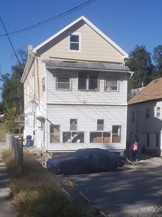

This Property Is For Sale
NEARBY LISTINGS FOR SALE OR LEASE
Property Detail
81 N Mill St
Kansas City, MO-KS
Mc Alipines Add To Wyndotte
093308
MC ALIPINES ADD TO WYNDOTTE & 0934, S9, T11, R25, ACRES 0.100000, B1 L17
Commercialnec
Wyandotte
X
Kansas
20209C0160E
17
2025
0.10 AC
2025
Downtown Kansas KC KS
042002
Kansas City
2,440 SF
DEMOGRAPHICS near 81 N Mill St
1 Mile
3 Mile
5 Mile
2024 Total Population
17,906
75,303
204,002
2029 Population
17,605
74,965
205,248
Pop Growth 2024-2029
(1.68%)
(0.45%)
+ 0.61%
Average Age
34
35
36
2024 Total Households
5,779
30,430
90,079
HH Growth 2024-2029
(1.75%)
+ 0.03%
+ 1.04%
Median Household Inc
$37,245
$52,402
$53,806
Avg Household Size
2.80
2.30
2.10
2024 Avg HH Vehicles
2.00
2.00
2.00
Median Home Value
$85,634
$103,153
$165,700
Median Year Built
1948
1951
1956
Nearby Places
Map Layers
Map Styles
 Street
 Aerial
- Restaurants
- Banks
- Shops
- Fitness
- Groceries
PUBLIC TRANSPORTATION
COMMUTER RAIL
DRIVE
WALK
Distance
11 min
4.1 mi
AIRPORT
Kansas City International
DRIVE
WALK
Distance
Kansas City International
29 min
18.0 mi
Nearby Properties
Address
Land Use
TOTAL SIZE
Lot Size
Zoning
Address
Land Use
TOTAL SIZE
Lot Size
Zoning
172,810 SF
Address
Land Use
TOTAL SIZE
Lot Size
Zoning
568,235 SF
9.59 AC
Address
Land Use
TOTAL SIZE
Lot Size
Zoning
126,962 SF
4.50 AC
KC0
Address
Land Use
TOTAL SIZE
Lot Size
Zoning
488,351 SF
8.34 AC
Address
Land Use
TOTAL SIZE
Lot Size
Zoning
132,304 SF
3.72 AC
KCD
Address
Land Use
TOTAL SIZE
Lot Size
Zoning
1,825,083 SF
25.77 AC
Address
Land Use
TOTAL SIZE
Lot Size
Zoning
404,524 SF
5.51 AC
Address
Land Use
TOTAL SIZE
Lot Size
Zoning
277,042 SF
0.40 AC
Address
Land Use
TOTAL SIZE
Lot Size
Zoning
277,267 SF
4.18 AC
KCD
Address
Land Use
TOTAL SIZE
Lot Size
Zoning
81,578 SF
1.63 AC
Address
Land Use
TOTAL SIZE
Lot Size
Zoning
162,989 SF
3.92 AC
KC0
Address
Land Use
TOTAL SIZE
Lot Size
Zoning
115,627 SF
1.56 AC
Address
Land Use
TOTAL SIZE
Lot Size
Zoning
261,570 SF
1.82 AC
Address
Land Use
TOTAL SIZE
Lot Size
Zoning
157,488 SF
1.60 AC
Address
Land Use
TOTAL SIZE
Lot Size
Zoning
87,294 SF
0.70 AC
Address
Land Use
TOTAL SIZE
Lot Size
Zoning
342,989 SF
1.84 AC
Address
Land Use
TOTAL SIZE
Lot Size
Zoning
139,499 SF
20.51 AC
KR1B
Address
Land Use
TOTAL SIZE
Lot Size
Zoning
93,870 SF
3.31 AC
KC0
Address
Land Use
TOTAL SIZE
Lot Size
Zoning
122,217 SF
23.87 AC
KR2
Address
Land Use
TOTAL SIZE
Lot Size
Zoning
238,003 SF
1.74 AC
Address
Land Use
TOTAL SIZE
Lot Size
Zoning
191,753 SF
0.79 AC
M1
Address
Land Use
TOTAL SIZE
Lot Size
Zoning
27,292 SF
10.75 AC
Address
Land Use
TOTAL SIZE
Lot Size
Zoning
250,410 SF
3.74 AC
Address
Land Use
TOTAL SIZE
Lot Size
Zoning
131,115 SF
2.80 AC
Address
Land Use
TOTAL SIZE
Lot Size
Zoning
50,504 SF
0.39 AC
Address
Land Use
TOTAL SIZE
Lot Size
Zoning
90,023 SF
1.18 AC
Address
Land Use
TOTAL SIZE
Lot Size
Zoning
122,247 SF
11.21 AC
KRP5
Address
Land Use
TOTAL SIZE
Lot Size
Zoning
99,060 SF
0.99 AC
Address
Land Use
TOTAL SIZE
Lot Size
Zoning
416,673 SF
8.74 AC
Address
Land Use
TOTAL SIZE
Lot Size
Zoning
296,548 SF
5.09 AC
The World's #1 Commercial Real Estate Marketplace
Connect with us
© 2026 CoStar Group
The information above has been obtained from sources believed reliable. While we do not doubt its accuracy we have not verified it and make no guarantee, warranty or representation about it. It is your responsibility to independently confirm its accuracy and completeness. Any projections, opinions, assumptions, or estimates used are for example only and do not represent the current or future performance of the property. The value of this transaction to you depends on tax and other factors which should be evaluated by your tax, financial, and legal advisors. You and your advisors should conduct a careful, independent investigation of the property to determine to your satisfaction the suitability of the property for your needs.