Property Record
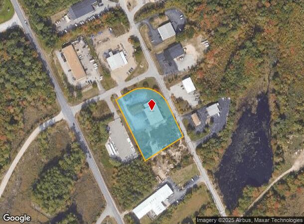
81 Priscilla Ln, Auburn, NH 03032
NEARBY LISTINGS FOR SALE OR LEASE
-
-
View all Auburn listings for sale on LoopNet.com
Property Detail
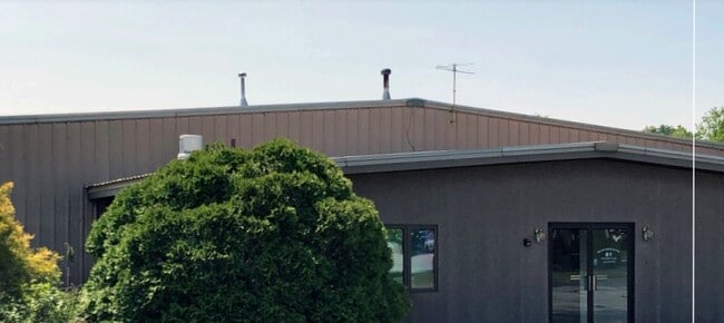
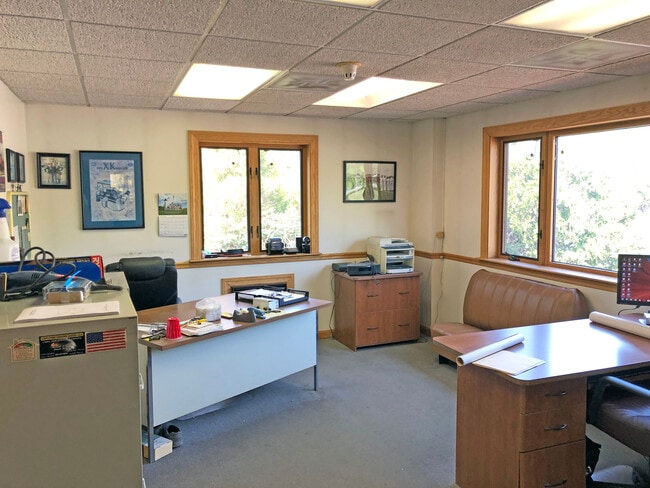
81 Priscilla Ln
AUBR-000001-000016-000021
Rockingham
Commercialbuilding
New Hampshire
X
21
33015C0328E
2.18 AC
2025
Rockingham
2025
Boston
004000
Boston-Cambridge-Newton, MA-NH
10,188 SF
DEMOGRAPHICS near 81 Priscilla Ln
1 mile
3 mile
5 mile
2024 Total Population
750
12,518
60,355
2029 Population
778
13,051
62,036
Pop Growth 2024-2029
+ 3.73%
+ 4.26%
+ 2.79%
Average Age
41
40
41
2024 Total Households
256
4,611
24,107
HH Growth 2024-2029
+ 3.91%
+ 4.23%
+ 2.69%
Median Household Inc
$143,560
$115,355
$92,179
Avg Household Size
2.90
2.60
2.40
2024 Avg HH Vehicles
3.00
2.00
2.00
Median Home Value
$563,084
$399,634
$350,651
Median Year Built
1977
1989
1978
Nearby Places
Map Layers
Map Styles
 Street
 Aerial
Transit
 Traffic
 Biking
Places
Listings with unknown addresses are not visible on the map
- Restaurants
- Banks
- Shops
- Fitness
- Groceries
PUBLIC TRANSPORTATION
AIRPORT
Manchester Boston Regional
Drive
Walk
Distance
Manchester Boston Regional
23 min
9.9 mi
Portsmouth International at Pease
Drive
Walk
Distance
Portsmouth International at Pease
62 min
46.0 mi
Freight Ports
Port of Boston
Drive
Walk
Distance
Port of Boston
68 min
49.9 mi
SALE & LEASE HISTORY
LISTING DATE
SALE/LEASE

Jun 09, 2023
For Sale
Nearby Properties
Address
Land Use
TOTAL SIZE
Lot Size
Zoning
Address
Land Use
TOTAL SIZE
Lot Size
Zoning
366,008 SF
41.69 AC
IND-I
Address
Land Use
TOTAL SIZE
Lot Size
Zoning
487,970 SF
79.74 AC
IND-I
Address
Land Use
TOTAL SIZE
Lot Size
Zoning
119,139 SF
25.87 AC
IND-I
Address
Land Use
TOTAL SIZE
Lot Size
Zoning
6 AC
RURAL
Address
Land Use
TOTAL SIZE
Lot Size
Zoning
125,060 SF
8.76 AC
IND-I
Address
Land Use
TOTAL SIZE
Lot Size
Zoning
722 SF
65 AC
Address
Land Use
TOTAL SIZE
Lot Size
Zoning
56,769 SF
20.09 AC
Address
Land Use
TOTAL SIZE
Lot Size
Zoning
133,900 SF
Address
Land Use
TOTAL SIZE
Lot Size
Zoning
952 SF
199 AC
AR-I
Address
Land Use
TOTAL SIZE
Lot Size
Zoning
160,452 SF
20.44 AC
Address
Land Use
TOTAL SIZE
Lot Size
Zoning
768 SF
1.90 AC
Address
Land Use
TOTAL SIZE
Lot Size
Zoning
104.90 AC
Address
Land Use
TOTAL SIZE
Lot Size
Zoning
106,200 SF
3.55 AC
C-II
Address
Land Use
TOTAL SIZE
Lot Size
Zoning
62,164 SF
25.47 AC
IND-I
Address
Land Use
TOTAL SIZE
Lot Size
Zoning
113.28 AC
Address
Land Use
TOTAL SIZE
Lot Size
Zoning
91,360 SF
Address
Land Use
TOTAL SIZE
Lot Size
Zoning
7,414 SF
5.32 AC
Address
Land Use
TOTAL SIZE
Lot Size
Zoning
2,866 SF
3.57 AC
Address
Land Use
TOTAL SIZE
Lot Size
Zoning
106,008 SF
7.80 AC
Address
Land Use
TOTAL SIZE
Lot Size
Zoning
52,711 SF
4.23 AC
Address
Land Use
TOTAL SIZE
Lot Size
Zoning
15,080 SF
9.18 AC
C-II
Address
Land Use
TOTAL SIZE
Lot Size
Zoning
73,640 SF
7.87 AC
Address
Land Use
TOTAL SIZE
Lot Size
Zoning
46,460 SF
6.55 AC
IND-II
Address
Land Use
TOTAL SIZE
Lot Size
Zoning
16,170 SF
10.26 AC
IND-I
Address
Land Use
TOTAL SIZE
Lot Size
Zoning
10.33 AC
I-II
Address
Land Use
TOTAL SIZE
Lot Size
Zoning
24,000 SF
32.17 AC
IND-II
Address
Land Use
TOTAL SIZE
Lot Size
Zoning
460 AC
RESID
Address
Land Use
TOTAL SIZE
Lot Size
Zoning
Address
Land Use
TOTAL SIZE
Lot Size
Zoning
22,378 SF
4.09 AC
C-II
Address
Land Use
TOTAL SIZE
Lot Size
Zoning
1,213 SF
30 AC
RESID
The World's #1 Commercial Real Estate Marketplace
Connect with us
© 2026 CoStar Group
The information above has been obtained from sources believed reliable. While we do not doubt its accuracy we have not verified it and make no guarantee, warranty or representation about it. It is your responsibility to independently confirm its accuracy and completeness. Any projections, opinions, assumptions, or estimates used are for example only and do not represent the current or future performance of the property. The value of this transaction to you depends on tax and other factors which should be evaluated by your tax, financial, and legal advisors. You and your advisors should conduct a careful, independent investigation of the property to determine to your satisfaction the suitability of the property for your needs.