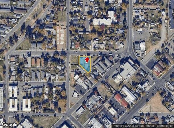
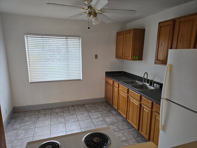
Property Record
810 Lampasas Ave, Sacramento, CA 95815
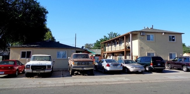

This Property Is For Sale
NEARBY LISTINGS FOR SALE OR LEASE
Property Detail
810 Lampasas Ave
265-0291-016
Sacramento 08
Apartment
PARCELS B & C ON PLAT OF SURVEY OF POR OF BLK 10OF NORTH SACRAMENTO SUB NO 8 AS SHOWN IN BK 8 OF SURVEYS MAP NO 14
X
Sacramento
06067C0177J
California
2024
0.38 AC
2025
Old North Sacramento
006802
Sacramento
6,240 SF
Sacramento-Roseville-Folsom, CA
DEMOGRAPHICS near 810 Lampasas Ave
1 Mile
3 Mile
5 Mile
2024 Total Population
20,286
152,740
377,020
2029 Population
20,487
154,252
381,223
Pop Growth 2024-2029
+ 0.99%
+ 0.99%
+ 1.11%
Average Age
36
36
38
2024 Total Households
6,539
53,979
148,281
HH Growth 2024-2029
+ 1.04%
+ 1.07%
+ 1.25%
Median Household Inc
$46,488
$58,047
$69,185
Avg Household Size
2.90
2.60
2.40
2024 Avg HH Vehicles
2.00
2.00
2.00
Median Home Value
$291,035
$384,000
$474,621
Median Year Built
1957
1970
1971
Nearby Places
Map Layers
Map Styles
 Street
 Aerial
- Restaurants
- Banks
- Shops
- Fitness
- Groceries
PUBLIC TRANSPORTATION
TRANSIT/SUBWAY
Royal Oaks (Blue Line - Sacramento Regional Transit District Light Rail (The RT))
DRIVE
WALK
Distance
Royal Oaks (Blue Line - Sacramento Regional Transit District Light Rail (The RT))
3 min
13 min
0.7 mi
Arden/Del Paso (Blue Line - Sacramento Regional Transit District Light Rail (The RT))
DRIVE
WALK
Distance
Arden/Del Paso (Blue Line - Sacramento Regional Transit District Light Rail (The RT))
2 min
17 min
0.9 mi
Swanston (Blue Line - Sacramento Regional Transit District Light Rail (The RT))
DRIVE
WALK
Distance
Swanston (Blue Line - Sacramento Regional Transit District Light Rail (The RT))
3 min
18 min
0.9 mi
COMMUTER RAIL
Sacramento (Capitol Corridor - Capitol Corridor Joint Powers Authority)
DRIVE
WALK
Distance
Sacramento (Capitol Corridor - Capitol Corridor Joint Powers Authority)
8 min
4.3 mi
AIRPORT
Sacramento International
DRIVE
WALK
Distance
Sacramento International
19 min
12.7 mi
Freight Ports
Port of Stockton
DRIVE
WALK
Distance
Port of Stockton
61 min
51.2 mi
Nearby Properties
Address
Land Use
TOTAL SIZE
Lot Size
Zoning
Address
Land Use
TOTAL SIZE
Lot Size
Zoning
201,132 SF
28.11 AC
C-2
Address
Land Use
TOTAL SIZE
Lot Size
Zoning
490,607 SF
32.63 AC
RD-30
Address
Land Use
TOTAL SIZE
Lot Size
Zoning
2.87 AC
C-2
Address
Land Use
TOTAL SIZE
Lot Size
Zoning
10.49 AC
C-2
Address
Land Use
TOTAL SIZE
Lot Size
Zoning
319,856 SF
12.27 AC
R-3-R-PUD
Address
Land Use
TOTAL SIZE
Lot Size
Zoning
226,731 SF
15.73 AC
OB-PUD
Address
Land Use
TOTAL SIZE
Lot Size
Zoning
0.65 AC
C-4-SPD
Address
Land Use
TOTAL SIZE
Lot Size
Zoning
390,860 SF
20.17 AC
R-3-R-PUD
Address
Land Use
TOTAL SIZE
Lot Size
Zoning
383,000 SF
25.52 AC
M-1
Address
Land Use
TOTAL SIZE
Lot Size
Zoning
335,346 SF
16.65 AC
SC-R-PUD
Address
Land Use
TOTAL SIZE
Lot Size
Zoning
156,649 SF
6.14 AC
LC
Address
Land Use
TOTAL SIZE
Lot Size
Zoning
218,732 SF
9.45 AC
R-2B-PUD
Address
Land Use
TOTAL SIZE
Lot Size
Zoning
74,008 SF
6.78 AC
H-PC
Address
Land Use
TOTAL SIZE
Lot Size
Zoning
136,152 SF
13.40 AC
AC LC
Address
Land Use
TOTAL SIZE
Lot Size
Zoning
168,560 SF
8.95 AC
RD-30
Address
Land Use
TOTAL SIZE
Lot Size
Zoning
207,273 SF
11.44 AC
R-2B-R-PUD
Address
Land Use
TOTAL SIZE
Lot Size
Zoning
152,000 SF
12.88 AC
SPA
Address
Land Use
TOTAL SIZE
Lot Size
Zoning
179,126 SF
9.48 AC
R-3A
Address
Land Use
TOTAL SIZE
Lot Size
Zoning
164,780 SF
7.98 AC
R-2B-PUD
Address
Land Use
TOTAL SIZE
Lot Size
Zoning
417,214 SF
23.66 AC
SPA
Address
Land Use
TOTAL SIZE
Lot Size
Zoning
4.49 AC
C-4-R
Address
Land Use
TOTAL SIZE
Lot Size
Zoning
15.83 AC
MRD-SPD
Address
Land Use
TOTAL SIZE
Lot Size
Zoning
99,491 SF
3.65 AC
C-2
Address
Land Use
TOTAL SIZE
Lot Size
Zoning
4.35 AC
C-2
Address
Land Use
TOTAL SIZE
Lot Size
Zoning
106,700 SF
5.38 AC
RD-30
Address
Land Use
TOTAL SIZE
Lot Size
Zoning
224,540 SF
11.07 AC
OB-PUD-SPD
Address
Land Use
TOTAL SIZE
Lot Size
Zoning
74,123 SF
3.55 AC
LC
Address
Land Use
TOTAL SIZE
Lot Size
Zoning
116,440 SF
8.59 AC
RD-30
Address
Land Use
TOTAL SIZE
Lot Size
Zoning
108,400 SF
5.51 AC
M-1S-R
Address
Land Use
TOTAL SIZE
Lot Size
Zoning
316,754 SF
21.68 AC
C-2
The World's #1 Commercial Real Estate Marketplace
Connect with us
© 2026 CoStar Group
The information above has been obtained from sources believed reliable. While we do not doubt its accuracy we have not verified it and make no guarantee, warranty or representation about it. It is your responsibility to independently confirm its accuracy and completeness. Any projections, opinions, assumptions, or estimates used are for example only and do not represent the current or future performance of the property. The value of this transaction to you depends on tax and other factors which should be evaluated by your tax, financial, and legal advisors. You and your advisors should conduct a careful, independent investigation of the property to determine to your satisfaction the suitability of the property for your needs.