Property Record
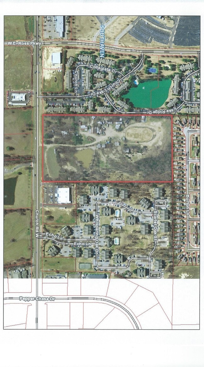
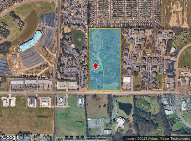
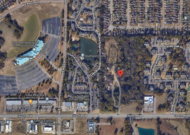
810 Church Rd, Nesbit, MS 38651
This Property Is For Sale
NEARBY LISTINGS FOR SALE OR LEASE
Property Detail
810 Church Rd
Memphis, TN-MS-AR
DeSoto
2081010000000400
Mississippi
Singlefamilyresidentialassumed
20.11 AC
X
DeSoto County
28033C0070H
Memphis
1,761 SF
DEMOGRAPHICS near 810 Church Rd
1 Mile
3 Mile
5 Mile
2024 Total Population
10,392
36,552
91,783
2029 Population
11,734
40,171
100,066
Pop Growth 2024-2029
+ 12.91%
+ 9.90%
+ 9.02%
Average Age
35
37
38
2024 Total Households
4,540
14,382
34,237
HH Growth 2024-2029
+ 12.95%
+ 10.08%
+ 9.12%
Median Household Inc
$43,997
$51,866
$58,718
Avg Household Size
2.30
2.50
2.60
2024 Avg HH Vehicles
2.00
2.00
2.00
Median Home Value
$154,921
$172,551
$190,119
Median Year Built
1998
1993
1993
Nearby Places
- Restaurants
- Banks
- Shops
- Fitness
- Groceries
PUBLIC TRANSPORTATION
AIRPORT
Memphis International
DRIVE
WALK
Distance
Memphis International
16 min
10.7 mi
Freight Ports
Port of Shreveport
DRIVE
WALK
Distance
Port of Shreveport
418 min
384.4 mi
Nearby Properties
Address
Land Use
TOTAL SIZE
Lot Size
Zoning
Address
Land Use
TOTAL SIZE
Lot Size
Zoning
1,040,736 SF
57.67 AC
M-1
Address
Land Use
TOTAL SIZE
Lot Size
Zoning
1,197,601 SF
59.47 AC
PBP
Address
Land Use
TOTAL SIZE
Lot Size
Zoning
73.05 AC
PBP
Address
Land Use
TOTAL SIZE
Lot Size
Zoning
868,060 SF
51.02 AC
PBP
Address
Land Use
TOTAL SIZE
Lot Size
Zoning
948,020 SF
62.60 AC
PBP
Address
Land Use
TOTAL SIZE
Lot Size
Zoning
23,183 SF
33.02 AC
PUD
Address
Land Use
TOTAL SIZE
Lot Size
Zoning
843,202 SF
51 AC
PBP
Address
Land Use
TOTAL SIZE
Lot Size
Zoning
39.98 AC
PUD
Address
Land Use
TOTAL SIZE
Lot Size
Zoning
62,561 SF
33.01 AC
PUD
Address
Land Use
TOTAL SIZE
Lot Size
Zoning
864,768 SF
44.14 AC
PBP
Address
Land Use
TOTAL SIZE
Lot Size
Zoning
56.29 AC
PBP
Address
Land Use
TOTAL SIZE
Lot Size
Zoning
18,830 SF
25.45 AC
PUD
Address
Land Use
TOTAL SIZE
Lot Size
Zoning
586,092 SF
51.64 AC
PBP
Address
Land Use
TOTAL SIZE
Lot Size
Zoning
15,472 SF
25.97 AC
PUD
Address
Land Use
TOTAL SIZE
Lot Size
Zoning
14,122 SF
24 AC
PUD
Address
Land Use
TOTAL SIZE
Lot Size
Zoning
552,590 SF
36.77 AC
PBP
Address
Land Use
TOTAL SIZE
Lot Size
Zoning
397,766 SF
37.80 AC
PBP
Address
Land Use
TOTAL SIZE
Lot Size
Zoning
515,317 SF
35.91 AC
PBP
Address
Land Use
TOTAL SIZE
Lot Size
Zoning
468,106 SF
22.28 AC
PBP
Address
Land Use
TOTAL SIZE
Lot Size
Zoning
34,358 SF
26.89 AC
C-4
Address
Land Use
TOTAL SIZE
Lot Size
Zoning
332,605 SF
25.85 AC
PBP
Address
Land Use
TOTAL SIZE
Lot Size
Zoning
10,341 SF
13.94 AC
RM-6
Address
Land Use
TOTAL SIZE
Lot Size
Zoning
12,775 SF
26.29 AC
PUD
Address
Land Use
TOTAL SIZE
Lot Size
Zoning
Address
Land Use
TOTAL SIZE
Lot Size
Zoning
330,598 SF
24.49 AC
PBP
Address
Land Use
TOTAL SIZE
Lot Size
Zoning
349,667 SF
15.98 AC
PBP
Address
Land Use
TOTAL SIZE
Lot Size
Zoning
70,434 SF
25 AC
C-4
Address
Land Use
TOTAL SIZE
Lot Size
Zoning
20,588 SF
14 AC
PUD
Address
Land Use
TOTAL SIZE
Lot Size
Zoning
301,448 SF
22.13 AC
PBP
Address
Land Use
TOTAL SIZE
Lot Size
Zoning
13,129 SF
12 AC
PUD
The World's #1 Commercial Real Estate Marketplace
Connect with us
© 2025 CoStar Group
The information above has been obtained from sources believed reliable. While we do not doubt its accuracy we have not verified it and make no guarantee, warranty or representation about it. It is your responsibility to independently confirm its accuracy and completeness. Any projections, opinions, assumptions, or estimates used are for example only and do not represent the current or future performance of the property. The value of this transaction to you depends on tax and other factors which should be evaluated by your tax, financial, and legal advisors. You and your advisors should conduct a careful, independent investigation of the property to determine to your satisfaction the suitability of the property for your needs.