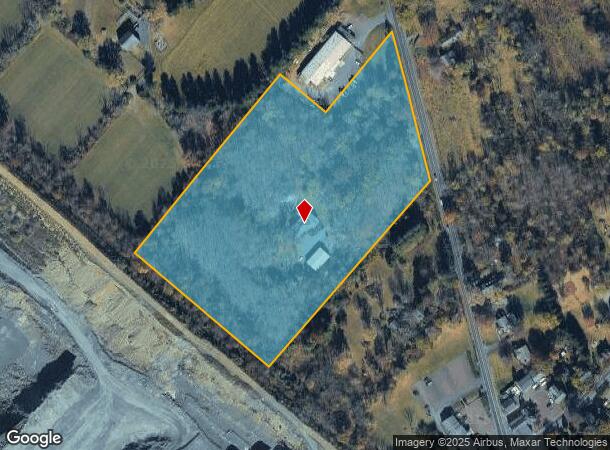
Property Record
4810 Durham Rd, Pipersville, PA 18947
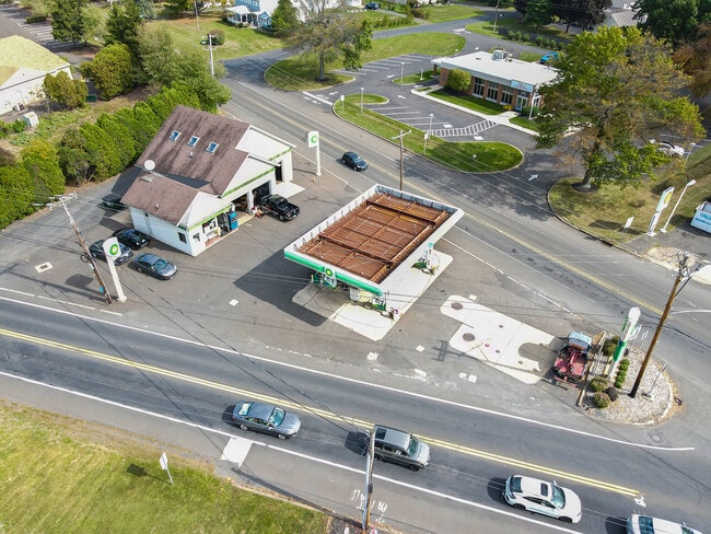
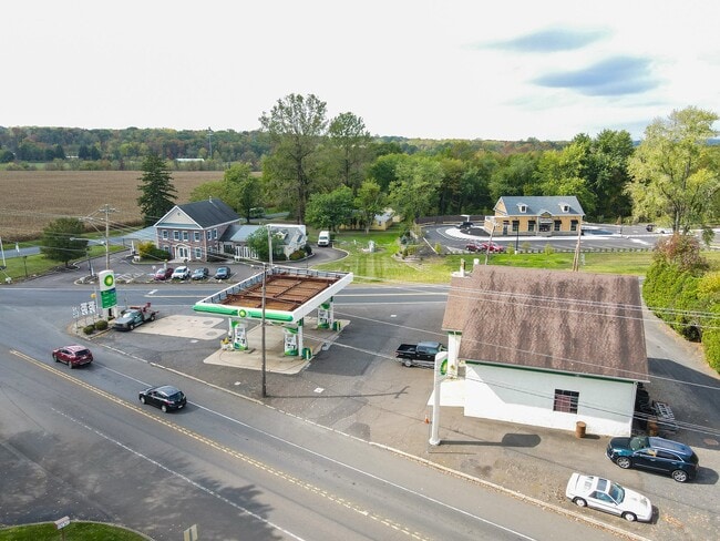
This Property Is For Sale
NEARBY LISTINGS FOR SALE OR LEASE
Property Detail
4810 Durham Rd
Philadelphia-Camden-Wilmington, PA-NJ-DE-MD
Duncan E Beaton Jr
34-015-022-001
10.002A W S DURHAM RD 854 N LR920 DURHAM ROAD
Residentialnec
Bucks
X
Pennsylvania
42017C0305J
pmstead
2024
10 AC
2025
Lower Bucks County
104203
Philadelphia
2,625 SF
DEMOGRAPHICS near 4810 Durham Rd
1 mile
3 mile
5 mile
2024 Total Population
1,518
12,009
45,701
2029 Population
1,470
11,807
45,227
Pop Growth 2024-2029
(3.16%)
(1.68%)
(1.04%)
Average Age
43
46
44
2024 Total Households
509
4,588
16,631
HH Growth 2024-2029
(3.34%)
(1.81%)
(1.13%)
Median Household Inc
$159,058
$138,314
$143,681
Avg Household Size
3.00
2.60
2.70
2024 Avg HH Vehicles
2.00
2.00
2.00
Median Home Value
$772,727
$601,901
$602,186
Median Year Built
1975
1989
1986
Nearby Places
Map Layers
Map Styles
 Street
 Aerial
Transit
 Traffic
 Biking
Places
Listings with unknown addresses are not visible on the map
- Restaurants
- Banks
- Shops
- Fitness
- Groceries
PUBLIC TRANSPORTATION
COMMUTER RAIL
Doylestown (R5 - Southeastern Pennsylvania Transportation Authority Regional Rail (SEPTA Regional Rail))
Drive
Walk
Distance
Doylestown (R5 - Southeastern Pennsylvania Transportation Authority Regional Rail (SEPTA Regional Rail))
13 min
6.4 mi
Delaware Valley College (R5 - Southeastern Pennsylvania Transportation Authority Regional Rail (SEPTA Regional Rail))
Drive
Walk
Distance
Delaware Valley College (R5 - Southeastern Pennsylvania Transportation Authority Regional Rail (SEPTA Regional Rail))
13 min
7.3 mi
AIRPORT
Trenton Mercer
Drive
Walk
Distance
Trenton Mercer
39 min
22.6 mi
Lehigh Valley International
Drive
Walk
Distance
Lehigh Valley International
58 min
32.0 mi
Freight Ports
Port of Philadelphia
Drive
Walk
Distance
Port of Philadelphia
56 min
32.6 mi
Nearby Properties
Address
Land Use
TOTAL SIZE
Lot Size
Zoning
Address
Land Use
TOTAL SIZE
Lot Size
Zoning
109,660 SF
9.81 AC
R3
Address
Land Use
TOTAL SIZE
Lot Size
Zoning
515 SF
128.48 AC
R1
Address
Land Use
TOTAL SIZE
Lot Size
Zoning
66,008 SF
13.28 AC
C3
Address
Land Use
TOTAL SIZE
Lot Size
Zoning
234,274 SF
24.12 AC
C4
Address
Land Use
TOTAL SIZE
Lot Size
Zoning
1,400 SF
30.14 AC
MHP
Address
Land Use
TOTAL SIZE
Lot Size
Zoning
72,320 SF
17.82 AC
I
Address
Land Use
TOTAL SIZE
Lot Size
Zoning
15,336 SF
9.10 AC
R3
Address
Land Use
TOTAL SIZE
Lot Size
Zoning
45,953 SF
2.12 AC
C2
Address
Land Use
TOTAL SIZE
Lot Size
Zoning
2,000 SF
8.62 AC
PI
Address
Land Use
TOTAL SIZE
Lot Size
Zoning
19,348 SF
4.86 AC
I
Address
Land Use
TOTAL SIZE
Lot Size
Zoning
561,638 SF
36.65 AC
RO
Address
Land Use
TOTAL SIZE
Lot Size
Zoning
14,571 SF
97.39 AC
R1
Address
Land Use
TOTAL SIZE
Lot Size
Zoning
61,059 SF
11.43 AC
I
Address
Land Use
TOTAL SIZE
Lot Size
Zoning
25,008 SF
4.05 AC
I
Address
Land Use
TOTAL SIZE
Lot Size
Zoning
12,309 SF
2.24 AC
C2
Address
Land Use
TOTAL SIZE
Lot Size
Zoning
78,057 SF
10.50 AC
I
Address
Land Use
TOTAL SIZE
Lot Size
Zoning
1,703 SF
1.24 AC
I
Address
Land Use
TOTAL SIZE
Lot Size
Zoning
18,010 SF
4.34 AC
C2
Address
Land Use
TOTAL SIZE
Lot Size
Zoning
36,664 SF
5.10 AC
I
Address
Land Use
TOTAL SIZE
Lot Size
Zoning
9,934 SF
15.07 AC
R2
Address
Land Use
TOTAL SIZE
Lot Size
Zoning
12,824 SF
4.03 AC
C2
Address
Land Use
TOTAL SIZE
Lot Size
Zoning
40,000 SF
7.36 AC
P1
Address
Land Use
TOTAL SIZE
Lot Size
Zoning
49,383 SF
4.45 AC
I
Address
Land Use
TOTAL SIZE
Lot Size
Zoning
1,808 SF
3 AC
I
Address
Land Use
TOTAL SIZE
Lot Size
Zoning
18,631 SF
1.83 AC
R3
Address
Land Use
TOTAL SIZE
Lot Size
Zoning
32,754 SF
8.03 AC
C2
Address
Land Use
TOTAL SIZE
Lot Size
Zoning
17,151 SF
3.04 AC
R3
Address
Land Use
TOTAL SIZE
Lot Size
Zoning
8,771 SF
32.25 AC
RO
Address
Land Use
TOTAL SIZE
Lot Size
Zoning
39,541 SF
12.96 AC
I
Address
Land Use
TOTAL SIZE
Lot Size
Zoning
22,680 SF
3.49 AC
R5
The World's #1 Commercial Real Estate Marketplace
Connect with us
© 2026 CoStar Group
The information above has been obtained from sources believed reliable. While we do not doubt its accuracy we have not verified it and make no guarantee, warranty or representation about it. It is your responsibility to independently confirm its accuracy and completeness. Any projections, opinions, assumptions, or estimates used are for example only and do not represent the current or future performance of the property. The value of this transaction to you depends on tax and other factors which should be evaluated by your tax, financial, and legal advisors. You and your advisors should conduct a careful, independent investigation of the property to determine to your satisfaction the suitability of the property for your needs.