Property Record
810 E 3Rd St, Los Angeles, CA 90013
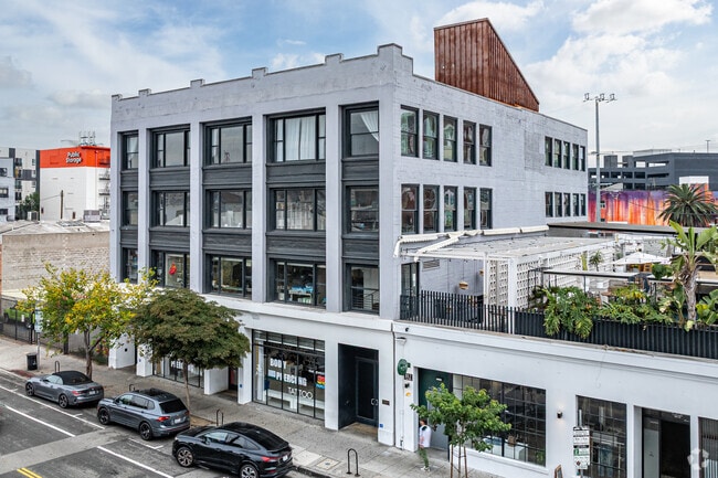


Property Detail
810 E 3Rd St
5163-015-016
THOMAS TRACT EX OF ST LOT 17 AND SW 20 FT EX OF ST OF LOT 18 BLK H
Retailwithmorethanonenonretailuse
Los Angeles
LAM3
California
B and X Area of moderate flood hazard, usually the area between the limits of the 100-year and 500-year floods.
17,18
2024
0.15 AC
2025
Downtown Los Angeles
206052
Los Angeles
29,250 SF
Los Angeles-Long Beach-Glendale, CA
NEARBY LISTINGS FOR SALE OR LEASE
DEMOGRAPHICS near 810 E 3Rd St
1 mile
3 mile
5 mile
2024 Total Population
48,479
411,541
1,123,570
2029 Population
48,482
409,471
1,113,432
Pop Growth 2024-2029
+ 0.01%
(0.50%)
(0.90%)
Average Age
43
38
38
2024 Total Households
19,912
145,060
380,414
HH Growth 2024-2029
+ 0.11%
(0.18%)
(0.78%)
Median Household Inc
$47,269
$57,108
$62,027
Avg Household Size
1.70
2.60
2.80
2024 Avg HH Vehicles
1.00
1.00
1.00
Median Home Value
$797,779
$779,500
$821,410
Median Year Built
1974
1965
1958
Nearby Places
Map Layers
Map Styles
 Street
 Aerial
Transit
 Traffic
 Biking
Places
Listings with unknown addresses are not visible on the map
- Restaurants
- Banks
- Shops
- Fitness
- Groceries
PUBLIC TRANSPORTATION
TRANSIT/SUBWAY
Little Tokyo-Arts District (Gold Line - Los Angeles County Metropolitan Transportation Authority (Metro))
Drive
Walk
Distance
Little Tokyo-Arts District (Gold Line - Los Angeles County Metropolitan Transportation Authority (Metro))
1 min
10 min
0.4 mi
Pico-Aliso (Gold Line - Los Angeles County Metropolitan Transportation Authority (Metro))
Drive
Walk
Distance
Pico-Aliso (Gold Line - Los Angeles County Metropolitan Transportation Authority (Metro))
2 min
14 min
0.7 mi
Historic Broadway Station (Metro A-Line - Metro - Los Angeles, Metro E-Line - Metro - Los Angeles)
Drive
Walk
Distance
Historic Broadway Station (Metro A-Line - Metro - Los Angeles, Metro E-Line - Metro - Los Angeles)
2 min
18 min
0.9 mi
Union Station (Gold Line - Los Angeles County Metropolitan Transportation Authority (Metro), Purple Line - Los Angeles County Metropolitan Transportation Authority (Metro), Red Line - Los Angeles County Metropolitan Transportation Authority (Metro))
Drive
Walk
Distance
Union Station (Gold Line - Los Angeles County Metropolitan Transportation Authority (Metro), Purple Line - Los Angeles County Metropolitan Transportation Authority (Metro), Red Line - Los Angeles County Metropolitan Transportation Authority (Metro))
4 min
20 min
1.1 mi
COMMUTER RAIL
Los Angeles (Coast Starlight - Amtrak, Pacific Surfliner - Amtrak, Southwest Chief - Amtrak, Texas Eagle - Amtrak)
Drive
Walk
Distance
Los Angeles (Coast Starlight - Amtrak, Pacific Surfliner - Amtrak, Southwest Chief - Amtrak, Texas Eagle - Amtrak)
2 min
19 min
0.9 mi
Union Station (91 Line - Southern California Regional Rail Authority (Metrolink), Antelope Valley Line - Southern California Regional Rail Authority (Metrolink), Orange County Line - Southern California Regional Rail Authority (Metrolink), Riverside Line - Southern California Regional Rail Authority (Metrolink), San Bernardino Line - Southern California Regional Rail Authority (Metrolink), Ventura County Line - Southern California Regional Rail Authority (Metrolink))
Drive
Walk
Distance
Union Station (91 Line - Southern California Regional Rail Authority (Metrolink), Antelope Valley Line - Southern California Regional Rail Authority (Metrolink), Orange County Line - Southern California Regional Rail Authority (Metrolink), Riverside Line - Southern California Regional Rail Authority (Metrolink), San Bernardino Line - Southern California Regional Rail Authority (Metrolink), Ventura County Line - Southern California Regional Rail Authority (Metrolink))
5 min
19 min
1.0 mi
AIRPORT
Bob Hope
Drive
Walk
Distance
Bob Hope
25 min
15.5 mi
Los Angeles International
Drive
Walk
Distance
Los Angeles International
27 min
16.2 mi
Long Beach (Daugherty Field)
Drive
Walk
Distance
Long Beach (Daugherty Field)
32 min
20.9 mi
Freight Ports
Port of Long Beach
Drive
Walk
Distance
Port of Long Beach
33 min
23.8 mi
SALE & LEASE HISTORY
LISTING DATE
SALE/LEASE

Sep 24, 2016
For Lease
Oct 15, 2019
For Lease
Oct 02, 2018
For Lease
May 12, 2022
For Lease
Mar 13, 2024
For Lease
Jul 15, 2021
For Lease
Jul 10, 2020
For Lease
Dec 02, 2016
For Lease
Nearby Properties
Address
Land Use
TOTAL SIZE
Lot Size
Zoning
Address
Land Use
TOTAL SIZE
Lot Size
Zoning
2,832,748 SF
4.20 AC
LAC2
Address
Land Use
TOTAL SIZE
Lot Size
Zoning
1,392,719 SF
4.22 AC
LAC4
Address
Land Use
TOTAL SIZE
Lot Size
Zoning
2,001,034 SF
2.71 AC
LAC2
Address
Land Use
TOTAL SIZE
Lot Size
Zoning
108,464 SF
9.17 AC
LALASED
Address
Land Use
TOTAL SIZE
Lot Size
Zoning
969,264 SF
0.94 AC
LAC2
Address
Land Use
TOTAL SIZE
Lot Size
Zoning
717,065 SF
0.99 AC
LAC2
Address
Land Use
TOTAL SIZE
Lot Size
Zoning
1,039,642 SF
2.84 AC
LAC2
Address
Land Use
TOTAL SIZE
Lot Size
Zoning
1,486,375 SF
3.77 AC
LAR5
Address
Land Use
TOTAL SIZE
Lot Size
Zoning
1,457,208 SF
1.39 AC
LAC2
Address
Land Use
TOTAL SIZE
Lot Size
Zoning
949,529 SF
1.50 AC
LAC2
Address
Land Use
TOTAL SIZE
Lot Size
Zoning
200,811 SF
4.59 AC
LALASED
Address
Land Use
TOTAL SIZE
Lot Size
Zoning
1,178,786 SF
3.89 AC
LAC2
Address
Land Use
TOTAL SIZE
Lot Size
Zoning
764,804 SF
1.48 AC
Address
Land Use
TOTAL SIZE
Lot Size
Zoning
634,863 SF
2.97 AC
LAC2-4D
Address
Land Use
TOTAL SIZE
Lot Size
Zoning
1,346,113 SF
1.17 AC
LAC5
Address
Land Use
TOTAL SIZE
Lot Size
Zoning
738,975 SF
2.71 AC
LAC2
Address
Land Use
TOTAL SIZE
Lot Size
Zoning
1,094,768 SF
0.73 AC
LAC2
Address
Land Use
TOTAL SIZE
Lot Size
Zoning
574,047 SF
1.70 AC
LAR5
Address
Land Use
TOTAL SIZE
Lot Size
Zoning
705,234 SF
1.83 AC
LAC2
Address
Land Use
TOTAL SIZE
Lot Size
Zoning
966,466 SF
3.99 AC
LAC2
Address
Land Use
TOTAL SIZE
Lot Size
Zoning
816,046 SF
15.37 AC
LAA1
Address
Land Use
TOTAL SIZE
Lot Size
Zoning
773,409 SF
1.39 AC
LAC4
Address
Land Use
TOTAL SIZE
Lot Size
Zoning
1,005,477 SF
1.36 AC
LAC4
Address
Land Use
TOTAL SIZE
Lot Size
Zoning
2,697,158 SF
20.18 AC
LAM2
Address
Land Use
TOTAL SIZE
Lot Size
Zoning
581,956 SF
0.89 AC
LAR5
Address
Land Use
TOTAL SIZE
Lot Size
Zoning
1,207,589 SF
1.01 AC
LAC2
Address
Land Use
TOTAL SIZE
Lot Size
Zoning
651,289 SF
3.79 AC
LACW
Address
Land Use
TOTAL SIZE
Lot Size
Zoning
1.28 AC
LAC2
Address
Land Use
TOTAL SIZE
Lot Size
Zoning
387,421 SF
1.08 AC
LAR5
Address
Land Use
TOTAL SIZE
Lot Size
Zoning
465,722 SF
5.84 AC
LAC4
The World's #1 Commercial Real Estate Marketplace
Connect with us
© 2026 CoStar Group
The information above has been obtained from sources believed reliable. While we do not doubt its accuracy we have not verified it and make no guarantee, warranty or representation about it. It is your responsibility to independently confirm its accuracy and completeness. Any projections, opinions, assumptions, or estimates used are for example only and do not represent the current or future performance of the property. The value of this transaction to you depends on tax and other factors which should be evaluated by your tax, financial, and legal advisors. You and your advisors should conduct a careful, independent investigation of the property to determine to your satisfaction the suitability of the property for your needs.