Property Record
810 E Dominguez St, Carson, CA 90746
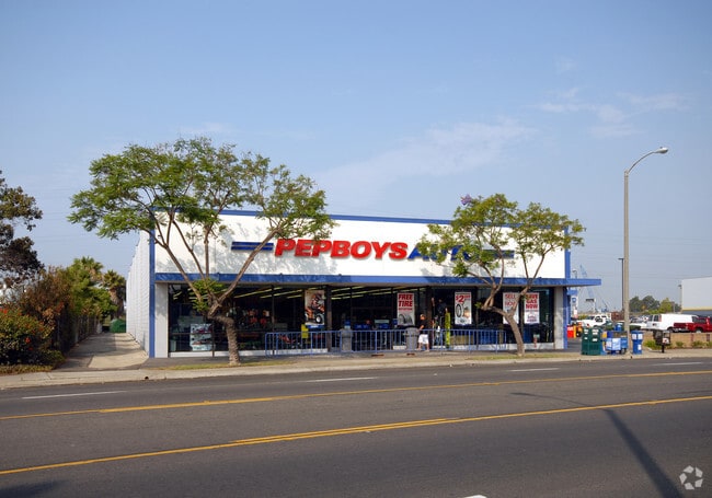

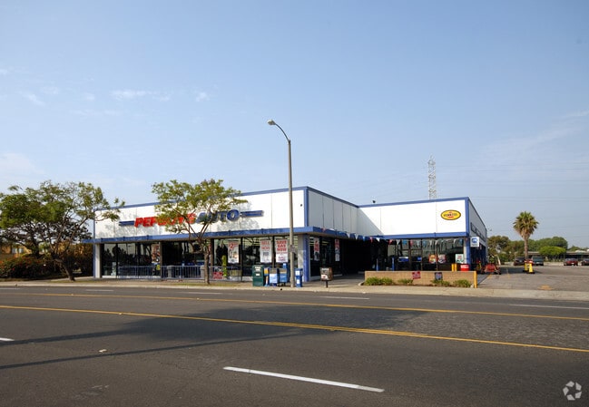

Property Detail
810 E Dominguez St
Los Angeles-Long Beach-Glendale, CA
PARCEL MAP AS PER BK 43 PG 33 OF P M LOT 4
7381-025-036
Los Angeles
Autorepair
California
CACR&D*
4
2025
1.31 AC
2025
Torrance
980025
Los Angeles
15,780 SF
NEARBY LISTINGS FOR SALE OR LEASE
DEMOGRAPHICS near 810 E Dominguez St
1 mile
3 mile
5 mile
2025 Total Population
18,175
146,806
553,065
2030 Population
18,071
145,085
546,614
Pop Growth 2025-2030
(0.57%)
(1.17%)
(1.17%)
Average Age
44
42
40
2025 Total Households
5,628
43,430
171,392
HH Growth 2025-2030
(0.75%)
(1.40%)
(1.35%)
Median Household Inc
$107,397
$99,008
$87,380
Avg Household Size
3.10
3.20
3.10
2025 Avg HH Vehicles
2.00
2.00
2.00
Median Home Value
$695,930
$695,749
$725,406
Median Year Built
1969
1964
1962
Nearby Places
Map Layers
Map Styles
 Street
 Aerial
Layers
 Traffic
 Biking
Places
Listings with unknown addresses are not visible on the map
- Restaurants
- Banks
- Shops
- Fitness
- Groceries
PUBLIC TRANSPORTATION
AIRPORT
Long Beach (Daugherty Field)
Drive
Walk
Distance
Long Beach (Daugherty Field)
12 min
7.4 mi
Los Angeles International
Drive
Walk
Distance
Los Angeles International
20 min
13.8 mi
John Wayne/Orange County
Drive
Walk
Distance
John Wayne/Orange County
34 min
27.6 mi
SALE & LEASE HISTORY
LISTING DATE
SALE/LEASE

Aug 20, 2024
For Lease
Nearby Properties
Address
Land Use
TOTAL SIZE
Lot Size
Zoning
Address
Land Use
TOTAL SIZE
Lot Size
Zoning
236,582 SF
425.41 AC
CAMH*
Address
Land Use
TOTAL SIZE
Lot Size
Zoning
64,456 SF
11.71 AC
CASP-10*
Address
Land Use
TOTAL SIZE
Lot Size
Zoning
422,640 SF
LAM3
Address
Land Use
TOTAL SIZE
Lot Size
Zoning
18,791 SF
54.78 AC
LCM2
Address
Land Use
TOTAL SIZE
Lot Size
Zoning
291,731 SF
16.84 AC
CAML*
Address
Land Use
TOTAL SIZE
Lot Size
Zoning
506,189 SF
20.33 AC
LAM2
Address
Land Use
TOTAL SIZE
Lot Size
Zoning
3,585,714 SF
67.35 AC
LAM3
Address
Land Use
TOTAL SIZE
Lot Size
Zoning
108,891 SF
224.14 AC
CAMH*
Address
Land Use
TOTAL SIZE
Lot Size
Zoning
409,522 SF
11.41 AC
LAM3
Address
Land Use
TOTAL SIZE
Lot Size
Zoning
184,300 SF
8.14 AC
LAM3
Address
Land Use
TOTAL SIZE
Lot Size
Zoning
285,314 SF
14.28 AC
CAMH*
Address
Land Use
TOTAL SIZE
Lot Size
Zoning
513,520 SF
19.09 AC
LBPD26
Address
Land Use
TOTAL SIZE
Lot Size
Zoning
260,766 SF
10.70 AC
LAM3
Address
Land Use
TOTAL SIZE
Lot Size
Zoning
429,141 SF
3.29 AC
LCM1*
Address
Land Use
TOTAL SIZE
Lot Size
Zoning
282,280 SF
Address
Land Use
TOTAL SIZE
Lot Size
Zoning
383,109 SF
17 AC
LCM2
Address
Land Use
TOTAL SIZE
Lot Size
Zoning
402,197 SF
27.29 AC
COMH*
Address
Land Use
TOTAL SIZE
Lot Size
Zoning
198,502 SF
LCM2 *
Address
Land Use
TOTAL SIZE
Lot Size
Zoning
365,701 SF
2.45 AC
TOMI-BP
Address
Land Use
TOTAL SIZE
Lot Size
Zoning
340,121 SF
13 AC
LCM2
Address
Land Use
TOTAL SIZE
Lot Size
Zoning
430,706 SF
18.95 AC
CASP-4*
Address
Land Use
TOTAL SIZE
Lot Size
Zoning
125,849 SF
6.08 AC
LAM2
Address
Land Use
TOTAL SIZE
Lot Size
Zoning
24,060 SF
LAM2
Address
Land Use
TOTAL SIZE
Lot Size
Zoning
178,323 SF
12.23 AC
CACR&D&MUR
Address
Land Use
TOTAL SIZE
Lot Size
Zoning
546,606 SF
17.58 AC
LAM3
Address
Land Use
TOTAL SIZE
Lot Size
Zoning
499,562 SF
6.50 AC
LAM3
Address
Land Use
TOTAL SIZE
Lot Size
Zoning
536,092 SF
3.79 AC
LAM3
Address
Land Use
TOTAL SIZE
Lot Size
Zoning
533,879 SF
10.02 AC
LAM2
Address
Land Use
TOTAL SIZE
Lot Size
Zoning
157,320 SF
7.18 AC
COMH*
Address
Land Use
TOTAL SIZE
Lot Size
Zoning
496,472 SF
21.57 AC
CAMH*
The World's #1 Commercial Real Estate Marketplace
Connect with us
© 2026 CoStar Group
The information above has been obtained from sources believed reliable. While we do not doubt its accuracy we have not verified it and make no guarantee, warranty or representation about it. It is your responsibility to independently confirm its accuracy and completeness. Any projections, opinions, assumptions, or estimates used are for example only and do not represent the current or future performance of the property. The value of this transaction to you depends on tax and other factors which should be evaluated by your tax, financial, and legal advisors. You and your advisors should conduct a careful, independent investigation of the property to determine to your satisfaction the suitability of the property for your needs.