Property Record
810 E State St, Fremont, OH 43420
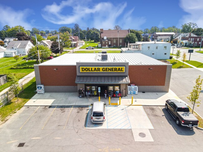

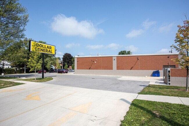
Property Detail
810 E State St
Fremont, OH
3177 & 3176 E 16.66' & 3174, 3175 & 3176 W 34'
34-50-00-3177-00
SANDUSKY
Commercialnec
Ohio
B and X Area of moderate flood hazard, usually the area between the limits of the 100-year and 500-year floods.
3177
2025
0.22 AC
2025
Sandusky County
961800
Toledo
1,576 SF
NEARBY LISTINGS FOR SALE OR LEASE
DEMOGRAPHICS near 810 E State St
1 mile
3 mile
5 mile
2025 Total Population
7,103
23,763
27,622
2030 Population
7,155
23,868
27,743
Pop Growth 2025-2030
+ 0.73%
+ 0.44%
+ 0.44%
Average Age
40
42
42
2025 Total Households
3,073
10,224
11,869
HH Growth 2025-2030
+ 0.68%
+ 0.42%
+ 0.41%
Median Household Inc
$52,178
$56,958
$58,979
Avg Household Size
2.20
2.20
2.20
2025 Avg HH Vehicles
2.00
2.00
2.00
Median Home Value
$134,117
$146,688
$151,075
Median Year Built
1956
1957
1959
Nearby Places
Map Layers
Map Styles
 Street
 Aerial
Layers
 Traffic
 Biking
Places
Listings with unknown addresses are not visible on the map
- Restaurants
- Banks
- Shops
- Fitness
- Groceries
SALE & LEASE HISTORY
LISTING DATE
SALE/LEASE

Sep 27, 2022
For Sale
Aug 06, 2020
For Sale
Nearby Properties
Address
Land Use
TOTAL SIZE
Lot Size
Zoning
Address
Land Use
TOTAL SIZE
Lot Size
Zoning
147,101 SF
72.51 AC
Address
Land Use
TOTAL SIZE
Lot Size
Zoning
15,600 SF
25.87 AC
Address
Land Use
TOTAL SIZE
Lot Size
Zoning
61,831 SF
4.13 AC
Address
Land Use
TOTAL SIZE
Lot Size
Zoning
17,672 SF
111.70 AC
Address
Land Use
TOTAL SIZE
Lot Size
Zoning
60,673 SF
14.72 AC
Address
Land Use
TOTAL SIZE
Lot Size
Zoning
26,714 SF
10.50 AC
Address
Land Use
TOTAL SIZE
Lot Size
Zoning
35,072 SF
6.30 AC
Address
Land Use
TOTAL SIZE
Lot Size
Zoning
33,008 SF
10.88 AC
Address
Land Use
TOTAL SIZE
Lot Size
Zoning
34,104 SF
16.17 AC
Address
Land Use
TOTAL SIZE
Lot Size
Zoning
38,801 SF
11.85 AC
Address
Land Use
TOTAL SIZE
Lot Size
Zoning
52,026 SF
3.88 AC
Address
Land Use
TOTAL SIZE
Lot Size
Zoning
22,320 SF
12.25 AC
Address
Land Use
TOTAL SIZE
Lot Size
Zoning
463,542 SF
25 AC
Address
Land Use
TOTAL SIZE
Lot Size
Zoning
80,000 SF
7.54 AC
Address
Land Use
TOTAL SIZE
Lot Size
Zoning
215,945 SF
21.75 AC
Address
Land Use
TOTAL SIZE
Lot Size
Zoning
131,520 SF
27.72 AC
Address
Land Use
TOTAL SIZE
Lot Size
Zoning
12,547 SF
23.91 AC
Address
Land Use
TOTAL SIZE
Lot Size
Zoning
90,200 SF
8.49 AC
Address
Land Use
TOTAL SIZE
Lot Size
Zoning
128,820 SF
16.91 AC
Address
Land Use
TOTAL SIZE
Lot Size
Zoning
256,000 SF
23.91 AC
Address
Land Use
TOTAL SIZE
Lot Size
Zoning
47,808 SF
0.60 AC
Address
Land Use
TOTAL SIZE
Lot Size
Zoning
17,170 SF
27 AC
Address
Land Use
TOTAL SIZE
Lot Size
Zoning
71,884 SF
5.58 AC
Address
Land Use
TOTAL SIZE
Lot Size
Zoning
135,709 SF
11.90 AC
Address
Land Use
TOTAL SIZE
Lot Size
Zoning
25,164 SF
2.81 AC
Address
Land Use
TOTAL SIZE
Lot Size
Zoning
22,692 SF
22.24 AC
Address
Land Use
TOTAL SIZE
Lot Size
Zoning
60,900 SF
27.42 AC
Address
Land Use
TOTAL SIZE
Lot Size
Zoning
22,467 SF
43.50 AC
Address
Land Use
TOTAL SIZE
Lot Size
Zoning
54,566 SF
6.72 AC
Address
Land Use
TOTAL SIZE
Lot Size
Zoning
2,344 SF
12.67 AC
The World's #1 Commercial Real Estate Marketplace
Connect with us
© 2026 CoStar Group
The information above has been obtained from sources believed reliable. While we do not doubt its accuracy we have not verified it and make no guarantee, warranty or representation about it. It is your responsibility to independently confirm its accuracy and completeness. Any projections, opinions, assumptions, or estimates used are for example only and do not represent the current or future performance of the property. The value of this transaction to you depends on tax and other factors which should be evaluated by your tax, financial, and legal advisors. You and your advisors should conduct a careful, independent investigation of the property to determine to your satisfaction the suitability of the property for your needs.