Property Record
810 Hogsback Rd, Mason, MI 48854
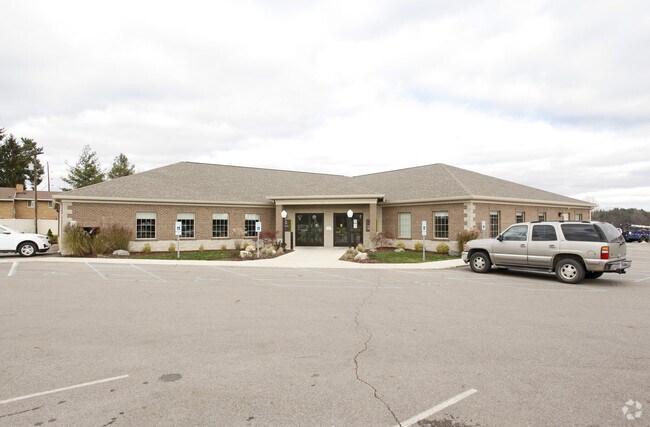

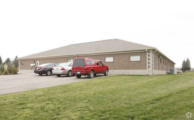
Property Detail
810 Hogsback Rd
06-06-31-151-006
AL 31-10 PART OF NW 1/4 OF SEC31 T3N R1W DESC AS: COM AT W 1/4 COR OF SEC 31 - N0D11'15E ALNG W SEC LN 1091.47 FT TO C/L OF
Medicalbuilding
Ingham
B-1
Michigan
B and X Area of moderate flood hazard, usually the area between the limits of the 100-year and 500-year floods.
2.15 AC
2024
Mason/SE Ingham County
2025
West Michigan
005600
Lansing-East Lansing, MI
7,686 SF
NEARBY LISTINGS FOR SALE OR LEASE
-
-
View all Mason listings for sale on LoopNet.com
DEMOGRAPHICS near 810 Hogsback Rd
1 mile
3 mile
5 mile
2025 Total Population
940
15,583
37,167
2030 Population
944
15,581
37,345
Pop Growth 2025-2030
+ 0.43%
(0.01%)
+ 0.48%
Average Age
42
40
41
2025 Total Households
362
6,304
15,357
HH Growth 2025-2030
+ 0.55%
+ 0.02%
+ 0.57%
Median Household Inc
$93,877
$89,332
$85,138
Avg Household Size
2.60
2.40
2.40
2025 Avg HH Vehicles
2.00
2.00
2.00
Median Home Value
$243,307
$220,446
$217,960
Median Year Built
1978
1980
1978
Nearby Places
Map Layers
Map Styles
 Street
 Aerial
Transit
 Traffic
 Biking
Places
Listings with unknown addresses are not visible on the map
- Restaurants
- Banks
- Shops
- Fitness
- Groceries
PUBLIC TRANSPORTATION
COMMUTER RAIL
Drive
Walk
Distance
14 min
9.9 mi
AIRPORT
Capital Region International
Drive
Walk
Distance
Capital Region International
25 min
16.4 mi
Nearby Properties
Address
Land Use
TOTAL SIZE
Lot Size
Zoning
Address
Land Use
TOTAL SIZE
Lot Size
Zoning
146,160 SF
88.98 AC
I-1
Address
Land Use
TOTAL SIZE
Lot Size
Zoning
15,000 SF
Address
Land Use
TOTAL SIZE
Lot Size
Zoning
107,580 SF
Address
Land Use
TOTAL SIZE
Lot Size
Zoning
178,096 SF
22.80 AC
IP
Address
Land Use
TOTAL SIZE
Lot Size
Zoning
269,915 SF
Address
Land Use
TOTAL SIZE
Lot Size
Zoning
912 SF
20.97 AC
RM
Address
Land Use
TOTAL SIZE
Lot Size
Zoning
7,868 SF
12.03 AC
RM
Address
Land Use
TOTAL SIZE
Lot Size
Zoning
8,341 SF
27.70 AC
RM
Address
Land Use
TOTAL SIZE
Lot Size
Zoning
616,146 SF
111.68 AC
IP
Address
Land Use
TOTAL SIZE
Lot Size
Zoning
14,981 SF
12.66 AC
R-1E
Address
Land Use
TOTAL SIZE
Lot Size
Zoning
23,254 SF
1.58 AC
C1
Address
Land Use
TOTAL SIZE
Lot Size
Zoning
16,913 SF
11.25 AC
R-1E
Address
Land Use
TOTAL SIZE
Lot Size
Zoning
15,439 SF
13.13 AC
R-1E
Address
Land Use
TOTAL SIZE
Lot Size
Zoning
137,084 SF
6.86 AC
M1
Address
Land Use
TOTAL SIZE
Lot Size
Zoning
18,468 SF
12.26 AC
RM
Address
Land Use
TOTAL SIZE
Lot Size
Zoning
128,381 SF
11.61 AC
IP
Address
Land Use
TOTAL SIZE
Lot Size
Zoning
65,728 SF
18.32 AC
IP
Address
Land Use
TOTAL SIZE
Lot Size
Zoning
55.34 AC
MH
Address
Land Use
TOTAL SIZE
Lot Size
Zoning
1,708 SF
20.73 AC
RM-1
Address
Land Use
TOTAL SIZE
Lot Size
Zoning
13,824 SF
15.39 AC
R-1E
Address
Land Use
TOTAL SIZE
Lot Size
Zoning
9,710 SF
5.19 AC
C-2
Address
Land Use
TOTAL SIZE
Lot Size
Zoning
7,341 SF
8.53 AC
RM-1
Address
Land Use
TOTAL SIZE
Lot Size
Zoning
Address
Land Use
TOTAL SIZE
Lot Size
Zoning
6,768 SF
228.81 AC
A-1
Address
Land Use
TOTAL SIZE
Lot Size
Zoning
11,520 SF
8.69 AC
RM
Address
Land Use
TOTAL SIZE
Lot Size
Zoning
216 SF
6.17 AC
RM
Address
Land Use
TOTAL SIZE
Lot Size
Zoning
18,468 SF
5.50 AC
RM
Address
Land Use
TOTAL SIZE
Lot Size
Zoning
5,922 SF
6.91 AC
RM-1
Address
Land Use
TOTAL SIZE
Lot Size
Zoning
31.63 AC
MH
Address
Land Use
TOTAL SIZE
Lot Size
Zoning
81,204 SF
12.08 AC
IA
The World's #1 Commercial Real Estate Marketplace
Connect with us
© 2026 CoStar Group
The information above has been obtained from sources believed reliable. While we do not doubt its accuracy we have not verified it and make no guarantee, warranty or representation about it. It is your responsibility to independently confirm its accuracy and completeness. Any projections, opinions, assumptions, or estimates used are for example only and do not represent the current or future performance of the property. The value of this transaction to you depends on tax and other factors which should be evaluated by your tax, financial, and legal advisors. You and your advisors should conduct a careful, independent investigation of the property to determine to your satisfaction the suitability of the property for your needs.