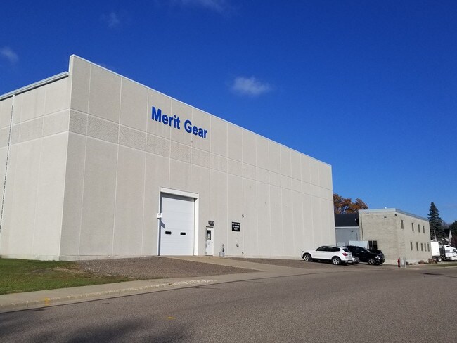
Property Record
810 Hudson St, Antigo, WI 54409


Property Detail
810 Hudson St
Other Market Areas
ORIGINAL PLAT PT OF LOTS 6 THRU 28 BLOCK 17 BEING LOT 1 CSM V4 P88 AKA CSM V6 P67 ALSO: PT LOTS 1 & 2 BLOCK 17 SD PLAT EXC PO
201-0235.003
Langlade
Industrialgeneral
Wisconsin
2025
1,1-2,6
2025
4.75 AC
960700
Wisconsin North Area
NEARBY LISTINGS FOR SALE OR LEASE
-
-
View all Antigo listings for sale on LoopNet.com
DEMOGRAPHICS near 810 Hudson St
1 mile
3 mile
5 mile
2025 Total Population
5,335
8,132
9,246
2030 Population
5,155
7,865
8,956
Pop Growth 2025-2030
(3.37%)
(3.28%)
(3.14%)
Average Age
42
42
42
2025 Total Households
2,377
3,587
4,036
HH Growth 2025-2030
(3.70%)
(3.60%)
(3.47%)
Median Household Inc
$44,982
$48,749
$51,450
Avg Household Size
2.10
2.10
2.20
2025 Avg HH Vehicles
2.00
2.00
2.00
Median Home Value
$90,180
$98,978
$111,435
Median Year Built
1959
1960
1963
Nearby Places
Map Layers
Map Styles
 Street
 Aerial
Layers
 Traffic
 Biking
Places
Listings with unknown addresses are not visible on the map
- Restaurants
- Banks
- Shops
- Fitness
- Groceries
SALE & LEASE HISTORY
LISTING DATE
SALE/LEASE

Nov 05, 2019
For Sale
Nearby Properties
Address
Land Use
TOTAL SIZE
Lot Size
Zoning
Address
Land Use
TOTAL SIZE
Lot Size
Zoning
10.59 AC
Address
Land Use
TOTAL SIZE
Lot Size
Zoning
1.56 AC
Address
Land Use
TOTAL SIZE
Lot Size
Zoning
21.42 AC
Address
Land Use
TOTAL SIZE
Lot Size
Zoning
10.56 AC
Address
Land Use
TOTAL SIZE
Lot Size
Zoning
15.63 AC
Address
Land Use
TOTAL SIZE
Lot Size
Zoning
11.89 AC
Address
Land Use
TOTAL SIZE
Lot Size
Zoning
4.42 AC
Address
Land Use
TOTAL SIZE
Lot Size
Zoning
Address
Land Use
TOTAL SIZE
Lot Size
Zoning
16.99 AC
Address
Land Use
TOTAL SIZE
Lot Size
Zoning
7.55 AC
Address
Land Use
TOTAL SIZE
Lot Size
Zoning
6.12 AC
Address
Land Use
TOTAL SIZE
Lot Size
Zoning
4.40 AC
Address
Land Use
TOTAL SIZE
Lot Size
Zoning
1.90 AC
Address
Land Use
TOTAL SIZE
Lot Size
Zoning
8.25 AC
Address
Land Use
TOTAL SIZE
Lot Size
Zoning
2.93 AC
Address
Land Use
TOTAL SIZE
Lot Size
Zoning
4.05 AC
Address
Land Use
TOTAL SIZE
Lot Size
Zoning
4.75 AC
Address
Land Use
TOTAL SIZE
Lot Size
Zoning
3.37 AC
Address
Land Use
TOTAL SIZE
Lot Size
Zoning
8.64 AC
Address
Land Use
TOTAL SIZE
Lot Size
Zoning
1.77 AC
Address
Land Use
TOTAL SIZE
Lot Size
Zoning
Address
Land Use
TOTAL SIZE
Lot Size
Zoning
3.73 AC
Address
Land Use
TOTAL SIZE
Lot Size
Zoning
3.99 AC
Address
Land Use
TOTAL SIZE
Lot Size
Zoning
4.06 AC
Address
Land Use
TOTAL SIZE
Lot Size
Zoning
18.62 AC
Address
Land Use
TOTAL SIZE
Lot Size
Zoning
Address
Land Use
TOTAL SIZE
Lot Size
Zoning
8.62 AC
Address
Land Use
TOTAL SIZE
Lot Size
Zoning
1.37 AC
Address
Land Use
TOTAL SIZE
Lot Size
Zoning
3.75 AC
The World's #1 Commercial Real Estate Marketplace
Connect with us
© 2026 CoStar Group
The information above has been obtained from sources believed reliable. While we do not doubt its accuracy we have not verified it and make no guarantee, warranty or representation about it. It is your responsibility to independently confirm its accuracy and completeness. Any projections, opinions, assumptions, or estimates used are for example only and do not represent the current or future performance of the property. The value of this transaction to you depends on tax and other factors which should be evaluated by your tax, financial, and legal advisors. You and your advisors should conduct a careful, independent investigation of the property to determine to your satisfaction the suitability of the property for your needs.