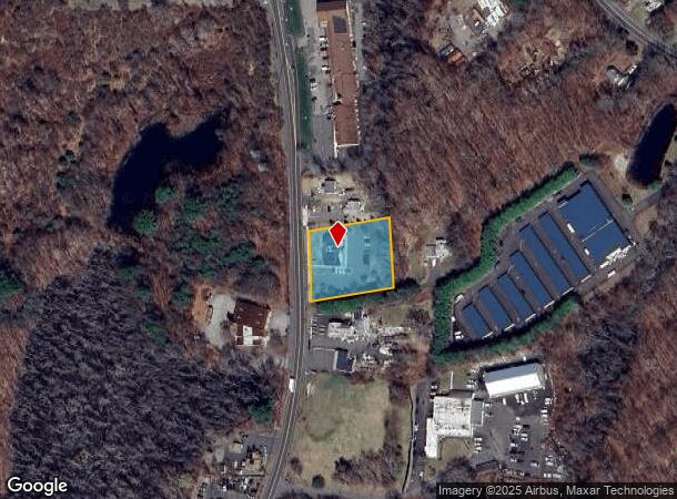
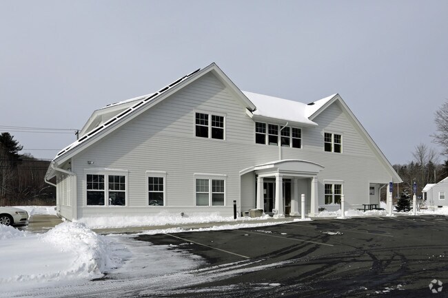
Property Record
810 Main St, Monroe, CT 06468

NEARBY LISTINGS FOR SALE OR LEASE
Property Detail
810 Main St
Commercialbuilding
Fairfield
X
Connecticut
09001C0257F
1.03 AC
2025
Monroe
2025
Westchester/So Connecticut
100100
Bridgeport-Stamford-Danbury, CT
5,640 SF
MONR-000093-000045
DEMOGRAPHICS near 810 Main St
1 mile
3 mile
5 mile
2024 Total Population
2,034
15,613
43,229
2029 Population
2,008
15,531
43,183
Pop Growth 2024-2029
(1.28%)
(0.53%)
(0.11%)
Average Age
43
42
42
2024 Total Households
796
5,492
15,011
HH Growth 2024-2029
(1.38%)
(0.69%)
(0.28%)
Median Household Inc
$112,113
$131,229
$138,725
Avg Household Size
2.50
2.80
2.80
2024 Avg HH Vehicles
2.00
2.00
2.00
Median Home Value
$366,406
$421,109
$441,237
Median Year Built
1982
1978
1976
Nearby Places
Map Layers
Map Styles
 Street
 Aerial
Transit
 Traffic
 Biking
Places
Listings with unknown addresses are not visible on the map
- Restaurants
- Banks
- Shops
- Fitness
- Groceries
PUBLIC TRANSPORTATION
AIRPORT
Tweed/New Haven
Drive
Walk
Distance
Tweed/New Haven
47 min
24.9 mi
Westchester County
Drive
Walk
Distance
Westchester County
64 min
42.3 mi
Freight Ports
Port of New Haven
Drive
Walk
Distance
Port of New Haven
41 min
22.8 mi
Nearby Properties
Address
Land Use
TOTAL SIZE
Lot Size
Zoning
Address
Land Use
TOTAL SIZE
Lot Size
Zoning
71.97 AC
RF2
Address
Land Use
TOTAL SIZE
Lot Size
Zoning
167,124 SF
37.33 AC
M-1
Address
Land Use
TOTAL SIZE
Lot Size
Zoning
43.38 AC
EH-10
Address
Land Use
TOTAL SIZE
Lot Size
Zoning
8.44 AC
B1
Address
Land Use
TOTAL SIZE
Lot Size
Zoning
175 AC
RF3 R
Address
Land Use
TOTAL SIZE
Lot Size
Zoning
19.16 AC
R-2
Address
Land Use
TOTAL SIZE
Lot Size
Zoning
10.07 AC
RF1H
Address
Land Use
TOTAL SIZE
Lot Size
Zoning
58,767 SF
32.50 AC
RF2
Address
Land Use
TOTAL SIZE
Lot Size
Zoning
23.95 AC
M-1
Address
Land Use
TOTAL SIZE
Lot Size
Zoning
53,107 SF
5.02 AC
B2
Address
Land Use
TOTAL SIZE
Lot Size
Zoning
252,800 SF
22.70 AC
M-1
Address
Land Use
TOTAL SIZE
Lot Size
Zoning
12,074 SF
22.73 AC
SDD1
Address
Land Use
TOTAL SIZE
Lot Size
Zoning
33,280 SF
2.45 AC
RF1H
Address
Land Use
TOTAL SIZE
Lot Size
Zoning
85,649 SF
16.15 AC
I2
Address
Land Use
TOTAL SIZE
Lot Size
Zoning
58,455 SF
5.75 AC
I-1
Address
Land Use
TOTAL SIZE
Lot Size
Zoning
19,803 SF
7.17 AC
RF1H
Address
Land Use
TOTAL SIZE
Lot Size
Zoning
7.52 AC
M-1
Address
Land Use
TOTAL SIZE
Lot Size
Zoning
114,140 SF
10.35 AC
I3
Address
Land Use
TOTAL SIZE
Lot Size
Zoning
15.72 AC
I2
Address
Land Use
TOTAL SIZE
Lot Size
Zoning
2,740 SF
99.96 AC
MFR
Address
Land Use
TOTAL SIZE
Lot Size
Zoning
41,569 SF
7.15 AC
I2
Address
Land Use
TOTAL SIZE
Lot Size
Zoning
40,144 SF
8.69 AC
M-1
Address
Land Use
TOTAL SIZE
Lot Size
Zoning
42,060 SF
16.64 AC
I2
Address
Land Use
TOTAL SIZE
Lot Size
Zoning
29,524 SF
5.67 AC
B2
Address
Land Use
TOTAL SIZE
Lot Size
Zoning
4 AC
B1
Address
Land Use
TOTAL SIZE
Lot Size
Zoning
7.50 AC
I2
Address
Land Use
TOTAL SIZE
Lot Size
Zoning
66,380 SF
8.02 AC
M-4
Address
Land Use
TOTAL SIZE
Lot Size
Zoning
30 AC
M-3
Address
Land Use
TOTAL SIZE
Lot Size
Zoning
28,013 SF
10.64 AC
M-1
Address
Land Use
TOTAL SIZE
Lot Size
Zoning
35,860 SF
12.03 AC
I2
The World's #1 Commercial Real Estate Marketplace
Connect with us
© 2026 CoStar Group
The information above has been obtained from sources believed reliable. While we do not doubt its accuracy we have not verified it and make no guarantee, warranty or representation about it. It is your responsibility to independently confirm its accuracy and completeness. Any projections, opinions, assumptions, or estimates used are for example only and do not represent the current or future performance of the property. The value of this transaction to you depends on tax and other factors which should be evaluated by your tax, financial, and legal advisors. You and your advisors should conduct a careful, independent investigation of the property to determine to your satisfaction the suitability of the property for your needs.