Property Record
810 Merrimack Ave, Dracut, MA 01826


NEARBY LISTINGS FOR SALE OR LEASE
Property Detail
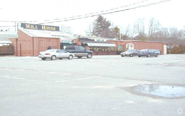
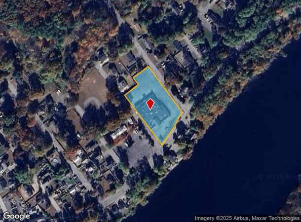
810 Merrimack Ave
DRAC-000073-000000-000001
Middlesex
Restaurantbuilding
Massachusetts
X
1
25009C0195G
1.69 AC
2025
Groton/Townsend
2025
Boston
314301
Boston-Cambridge-Newton, MA-NH
23,371 SF
DEMOGRAPHICS near 810 Merrimack Ave
1 Mile
3 Mile
5 Mile
2024 Total Population
3,689
56,640
196,628
2029 Population
3,685
55,820
193,694
Pop Growth 2024-2029
(0.11%)
(1.45%)
(1.49%)
Average Age
42
40
39
2024 Total Households
1,305
21,176
70,383
HH Growth 2024-2029
(0.31%)
(1.58%)
(1.52%)
Median Household Inc
$128,289
$86,291
$82,334
Avg Household Size
2.80
2.60
2.60
2024 Avg HH Vehicles
2.00
2.00
2.00
Median Home Value
$634,914
$457,440
$429,232
Median Year Built
1982
1965
1963
Nearby Places
Map Layers
Map Styles
 Street
 Aerial
- Restaurants
- Banks
- Shops
- Fitness
- Groceries
PUBLIC TRANSPORTATION
COMMUTER RAIL
Lowell (Lowell Line - Massachusetts Bay Transportation Authority Commuter Rail (Purple Line))
DRIVE
WALK
Distance
Lowell (Lowell Line - Massachusetts Bay Transportation Authority Commuter Rail (Purple Line))
8 min
4.5 mi
North Billerica (Lowell Line - Massachusetts Bay Transportation Authority Commuter Rail (Purple Line))
DRIVE
WALK
Distance
North Billerica (Lowell Line - Massachusetts Bay Transportation Authority Commuter Rail (Purple Line))
15 min
7.5 mi
AIRPORT
Manchester Boston Regional
DRIVE
WALK
Distance
Manchester Boston Regional
44 min
29.1 mi
General Edward Lawrence Logan International
DRIVE
WALK
Distance
General Edward Lawrence Logan International
44 min
32.8 mi
Freight Ports
Port of Boston
DRIVE
WALK
Distance
Port of Boston
45 min
32.6 mi
SALE & LEASE HISTORY
LISTING DATE
SALE/LEASE

Jun 21, 2021
For Sale
Nearby Properties
Address
Land Use
TOTAL SIZE
Lot Size
Zoning
Address
Land Use
TOTAL SIZE
Lot Size
Zoning
52.80 AC
OR
Address
Land Use
TOTAL SIZE
Lot Size
Zoning
52.02 AC
ID
Address
Land Use
TOTAL SIZE
Lot Size
Zoning
382,753 SF
25.86 AC
ID2
Address
Land Use
TOTAL SIZE
Lot Size
Zoning
803 SF
3.29 AC
R1
Address
Land Use
TOTAL SIZE
Lot Size
Zoning
215,884 SF
1.55 AC
DMU
Address
Land Use
TOTAL SIZE
Lot Size
Zoning
134,439 SF
3.29 AC
DMU
Address
Land Use
TOTAL SIZE
Lot Size
Zoning
67.55 AC
OR
Address
Land Use
TOTAL SIZE
Lot Size
Zoning
96.66 AC
ID
Address
Land Use
TOTAL SIZE
Lot Size
Zoning
6.27 AC
DMU
Address
Land Use
TOTAL SIZE
Lot Size
Zoning
225,252 SF
2.31 AC
DMU
Address
Land Use
TOTAL SIZE
Lot Size
Zoning
152,040 SF
9.10 AC
SRC
Address
Land Use
TOTAL SIZE
Lot Size
Zoning
20.88 AC
TSF
Address
Land Use
TOTAL SIZE
Lot Size
Zoning
185,172 SF
2.93 AC
DMU
Address
Land Use
TOTAL SIZE
Lot Size
Zoning
245,562 SF
1.44 AC
DMU
Address
Land Use
TOTAL SIZE
Lot Size
Zoning
13.74 AC
SSF
Address
Land Use
TOTAL SIZE
Lot Size
Zoning
162,978 SF
13.73 AC
ID2
Address
Land Use
TOTAL SIZE
Lot Size
Zoning
2.35 AC
DMU
Address
Land Use
TOTAL SIZE
Lot Size
Zoning
27.15 AC
ID
Address
Land Use
TOTAL SIZE
Lot Size
Zoning
122,533 SF
2.37 AC
DMU
Address
Land Use
TOTAL SIZE
Lot Size
Zoning
105,826 SF
2.27 AC
DMU
Address
Land Use
TOTAL SIZE
Lot Size
Zoning
124,760 SF
13.51 AC
ID
Address
Land Use
TOTAL SIZE
Lot Size
Zoning
172,622 SF
22.32 AC
COM
Address
Land Use
TOTAL SIZE
Lot Size
Zoning
135,500 SF
17.96 AC
OR
Address
Land Use
TOTAL SIZE
Lot Size
Zoning
84,282 SF
23.15 AC
SSF
Address
Land Use
TOTAL SIZE
Lot Size
Zoning
73.74 AC
IH
Address
Land Use
TOTAL SIZE
Lot Size
Zoning
73,034 SF
2.30 AC
TMF
Address
Land Use
TOTAL SIZE
Lot Size
Zoning
74.10 AC
SRC
Address
Land Use
TOTAL SIZE
Lot Size
Zoning
90,404 SF
6 AC
ID
Address
Land Use
TOTAL SIZE
Lot Size
Zoning
125,896 SF
9.41 AC
ID
Address
Land Use
TOTAL SIZE
Lot Size
Zoning
3.75 AC
UMF
The World's #1 Commercial Real Estate Marketplace
Connect with us
© 2026 CoStar Group
The information above has been obtained from sources believed reliable. While we do not doubt its accuracy we have not verified it and make no guarantee, warranty or representation about it. It is your responsibility to independently confirm its accuracy and completeness. Any projections, opinions, assumptions, or estimates used are for example only and do not represent the current or future performance of the property. The value of this transaction to you depends on tax and other factors which should be evaluated by your tax, financial, and legal advisors. You and your advisors should conduct a careful, independent investigation of the property to determine to your satisfaction the suitability of the property for your needs.