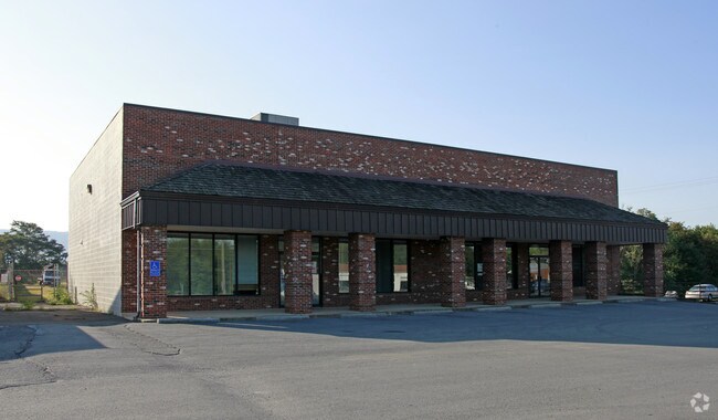
Property Record
810 N Main St, Woodstock, VA 22664

NEARBY LISTINGS FOR SALE OR LEASE
-
-
View all Woodstock listings for sale on LoopNet.com
Property Detail
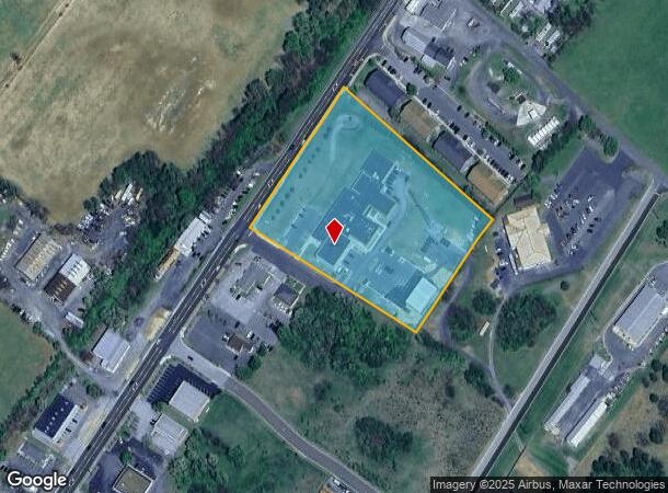
810 N Main St
046-A-061B
Woodstock North
Officebuilding
WOODSTOCK NORTH SUBD SEC 2 PARCEL 3 SHERIFF'S OFFICE
X
Shenandoah
51171C0163C
Virginia
0
5.13 AC
2025
Virginia Shenandoah Valley Regional
040501
Other Market Areas
31,728 SF
DEMOGRAPHICS near 810 N Main St
1 Mile
3 Mile
5 Mile
2024 Total Population
1,926
8,803
13,372
2029 Population
2,016
9,238
14,051
Pop Growth 2024-2029
+ 4.67%
+ 4.94%
+ 5.08%
Average Age
40
42
43
2024 Total Households
777
3,532
5,386
HH Growth 2024-2029
+ 4.63%
+ 4.93%
+ 5.07%
Median Household Inc
$60,324
$61,106
$61,342
Avg Household Size
2.40
2.40
2.40
2024 Avg HH Vehicles
2.00
2.00
2.00
Median Home Value
$253,367
$260,440
$257,670
Median Year Built
1980
1984
1982
Nearby Places
Map Layers
Map Styles
 Street
 Aerial
- Restaurants
- Banks
- Shops
- Fitness
- Groceries
Nearby Properties
Address
Land Use
TOTAL SIZE
Lot Size
Zoning
Address
Land Use
TOTAL SIZE
Lot Size
Zoning
97,785 SF
38 AC
Address
Land Use
TOTAL SIZE
Lot Size
Zoning
158,486 SF
21 AC
Address
Land Use
TOTAL SIZE
Lot Size
Zoning
11.51 AC
Address
Land Use
TOTAL SIZE
Lot Size
Zoning
163,467 SF
16.89 AC
Address
Land Use
TOTAL SIZE
Lot Size
Zoning
146,934 SF
22.15 AC
Address
Land Use
TOTAL SIZE
Lot Size
Zoning
53,730 SF
6.83 AC
Address
Land Use
TOTAL SIZE
Lot Size
Zoning
103,513 SF
9.71 AC
0000
Address
Land Use
TOTAL SIZE
Lot Size
Zoning
9.85 AC
Address
Land Use
TOTAL SIZE
Lot Size
Zoning
32,836 SF
4.74 AC
Address
Land Use
TOTAL SIZE
Lot Size
Zoning
41,195 SF
3.20 AC
Address
Land Use
TOTAL SIZE
Lot Size
Zoning
69,700 SF
3.65 AC
Address
Land Use
TOTAL SIZE
Lot Size
Zoning
49,115 SF
3.74 AC
Address
Land Use
TOTAL SIZE
Lot Size
Zoning
68,005 SF
3.82 AC
Address
Land Use
TOTAL SIZE
Lot Size
Zoning
20,048 SF
5.27 AC
Address
Land Use
TOTAL SIZE
Lot Size
Zoning
2,064 SF
8.31 AC
Address
Land Use
TOTAL SIZE
Lot Size
Zoning
3,150 SF
52.20 AC
Address
Land Use
TOTAL SIZE
Lot Size
Zoning
16,005 SF
2.27 AC
Address
Land Use
TOTAL SIZE
Lot Size
Zoning
25,576 SF
7.16 AC
Address
Land Use
TOTAL SIZE
Lot Size
Zoning
23,528 SF
4.41 AC
Address
Land Use
TOTAL SIZE
Lot Size
Zoning
29,245 SF
2.26 AC
Address
Land Use
TOTAL SIZE
Lot Size
Zoning
11,564 SF
4.10 AC
Address
Land Use
TOTAL SIZE
Lot Size
Zoning
25,888 SF
3.32 AC
Address
Land Use
TOTAL SIZE
Lot Size
Zoning
36,188 SF
1.83 AC
Address
Land Use
TOTAL SIZE
Lot Size
Zoning
30,616 SF
4.88 AC
Address
Land Use
TOTAL SIZE
Lot Size
Zoning
19,908 SF
4 AC
Address
Land Use
TOTAL SIZE
Lot Size
Zoning
10,440 SF
1.39 AC
B2
Address
Land Use
TOTAL SIZE
Lot Size
Zoning
19,451 SF
1.57 AC
Address
Land Use
TOTAL SIZE
Lot Size
Zoning
22,075 SF
3.63 AC
Address
Land Use
TOTAL SIZE
Lot Size
Zoning
60,921 SF
3.04 AC
The World's #1 Commercial Real Estate Marketplace
Connect with us
© 2026 CoStar Group
The information above has been obtained from sources believed reliable. While we do not doubt its accuracy we have not verified it and make no guarantee, warranty or representation about it. It is your responsibility to independently confirm its accuracy and completeness. Any projections, opinions, assumptions, or estimates used are for example only and do not represent the current or future performance of the property. The value of this transaction to you depends on tax and other factors which should be evaluated by your tax, financial, and legal advisors. You and your advisors should conduct a careful, independent investigation of the property to determine to your satisfaction the suitability of the property for your needs.