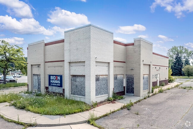
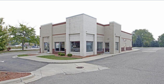
Property Record
810 N Perry St, Pontiac, MI 48342

NEARBY LISTINGS FOR SALE OR LEASE
Property Detail
810 N Perry St
Detroit-Warren-Dearborn, MI
Assessors Plat No 1
14-21-403-057
T3N, R10E, SEC 21 ASSESSOR'S PLAT NO 13 LOT 43 EXC THAT PART TAKEN FOR PERRY ST DESC AS LYING SELY OF LINE BEG AT INTERSEC OF SWLY LINE OF LOT 43 & SELY LINE OF PERRY ST (80 FT R/W), TH NELY 17 FT ALG R/W LINE, TH NELY 130.38 FT M/L TO PT LOT NELY 27
Restaurantdrivein
Oakland
X
Michigan
26125C0369F
43
2024
0.95 AC
2024
Pontiac
141600
Detroit
3,288 SF
DEMOGRAPHICS near 810 N Perry St
1 Mile
3 Mile
5 Mile
2024 Total Population
11,848
68,886
159,566
2029 Population
11,774
68,825
159,200
Pop Growth 2024-2029
(0.62%)
(0.09%)
(0.23%)
Average Age
35
37
40
2024 Total Households
4,364
27,270
65,498
HH Growth 2024-2029
(0.69%)
(0.19%)
(0.28%)
Median Household Inc
$39,542
$40,433
$60,518
Avg Household Size
2.50
2.40
2.30
2024 Avg HH Vehicles
2.00
2.00
2.00
Median Home Value
$66,257
$91,961
$215,314
Median Year Built
1954
1960
1970
Nearby Places
Map Layers
Map Styles
 Street
 Aerial
- Restaurants
- Banks
- Shops
- Fitness
- Groceries
PUBLIC TRANSPORTATION
COMMUTER RAIL
DRIVE
WALK
Distance
6 min
2.1 mi
AIRPORT
Bishop International
DRIVE
WALK
Distance
Bishop International
57 min
38.9 mi
Windsor International
DRIVE
WALK
Distance
Windsor International
60 min
39.8 mi
Detroit Metro Wayne County
DRIVE
WALK
Distance
Detroit Metro Wayne County
65 min
49.4 mi
SALE & LEASE HISTORY
LISTING DATE
SALE/LEASE

Mar 29, 2017
For Lease
Jan 19, 2018
For Sale
Feb 28, 2024
For Sale
Nearby Properties
Address
Land Use
TOTAL SIZE
Lot Size
Zoning
Address
Land Use
TOTAL SIZE
Lot Size
Zoning
7,879,586 SF
457.68 AC
TR
Address
Land Use
TOTAL SIZE
Lot Size
Zoning
2,734,739 SF
80.39 AC
Address
Land Use
TOTAL SIZE
Lot Size
Zoning
803,597 SF
67 AC
SP
Address
Land Use
TOTAL SIZE
Lot Size
Zoning
238,755 SF
Address
Land Use
TOTAL SIZE
Lot Size
Zoning
316,358 SF
20.89 AC
P
Address
Land Use
TOTAL SIZE
Lot Size
Zoning
1,771,589 SF
96.73 AC
Address
Land Use
TOTAL SIZE
Lot Size
Zoning
430,338 SF
46.09 AC
Address
Land Use
TOTAL SIZE
Lot Size
Zoning
608,251 SF
50.49 AC
II
Address
Land Use
TOTAL SIZE
Lot Size
Zoning
238,755 SF
18.12 AC
Address
Land Use
TOTAL SIZE
Lot Size
Zoning
487,797 SF
34.74 AC
TR
Address
Land Use
TOTAL SIZE
Lot Size
Zoning
278,387 SF
43.37 AC
Address
Land Use
TOTAL SIZE
Lot Size
Zoning
430,338 SF
43.22 AC
Address
Land Use
TOTAL SIZE
Lot Size
Zoning
214,772 SF
Address
Land Use
TOTAL SIZE
Lot Size
Zoning
601,151 SF
Address
Land Use
TOTAL SIZE
Lot Size
Zoning
278,387 SF
Address
Land Use
TOTAL SIZE
Lot Size
Zoning
135,230 SF
Address
Land Use
TOTAL SIZE
Lot Size
Zoning
174,019 SF
9.66 AC
Address
Land Use
TOTAL SIZE
Lot Size
Zoning
186,242 SF
Address
Land Use
TOTAL SIZE
Lot Size
Zoning
172,076 SF
11.18 AC
Address
Land Use
TOTAL SIZE
Lot Size
Zoning
136,061 SF
14.64 AC
Address
Land Use
TOTAL SIZE
Lot Size
Zoning
199,125 SF
47.43 AC
Address
Land Use
TOTAL SIZE
Lot Size
Zoning
52,968 SF
3.73 AC
Address
Land Use
TOTAL SIZE
Lot Size
Zoning
205,703 SF
21.63 AC
B2
Address
Land Use
TOTAL SIZE
Lot Size
Zoning
120,859 SF
14.63 AC
Address
Land Use
TOTAL SIZE
Lot Size
Zoning
148,825 SF
Address
Land Use
TOTAL SIZE
Lot Size
Zoning
107,376 SF
10.18 AC
Address
Land Use
TOTAL SIZE
Lot Size
Zoning
142,858 SF
Address
Land Use
TOTAL SIZE
Lot Size
Zoning
120,859 SF
Address
Land Use
TOTAL SIZE
Lot Size
Zoning
79,263 SF
22.27 AC
Address
Land Use
TOTAL SIZE
Lot Size
Zoning
903,018 SF
73.92 AC
II
The World's #1 Commercial Real Estate Marketplace
Connect with us
© 2025 CoStar Group
The information above has been obtained from sources believed reliable. While we do not doubt its accuracy we have not verified it and make no guarantee, warranty or representation about it. It is your responsibility to independently confirm its accuracy and completeness. Any projections, opinions, assumptions, or estimates used are for example only and do not represent the current or future performance of the property. The value of this transaction to you depends on tax and other factors which should be evaluated by your tax, financial, and legal advisors. You and your advisors should conduct a careful, independent investigation of the property to determine to your satisfaction the suitability of the property for your needs.