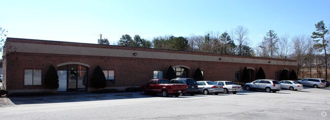
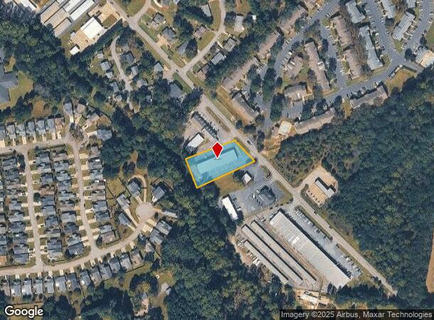
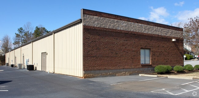
Property Record
810 Powdersville Rd, Easley, SC 29642
Current Lease Availabilities
NEARBY LISTINGS FOR SALE OR LEASE
Property Detail
810 Powdersville Rd
5038-06-39-1276
TRACT A 2 PLAT 38/146
Officebuilding
Pickens
X
South Carolina
45007C0035E
0.87 AC
2025
Outlying Pickens County
2024
Greenville/Spartanburg
010905
Greenville-Anderson-Mauldin, SC
8,100 SF
DEMOGRAPHICS near 810 Powdersville Rd
1 Mile
3 Mile
5 Mile
2024 Total Population
4,870
29,118
59,312
2029 Population
5,029
30,465
62,357
Pop Growth 2024-2029
+ 3.26%
+ 4.63%
+ 5.13%
Average Age
43
41
41
2024 Total Households
2,213
11,963
23,444
HH Growth 2024-2029
+ 3.34%
+ 4.66%
+ 5.17%
Median Household Inc
$52,846
$60,053
$60,709
Avg Household Size
2.20
2.40
2.50
2024 Avg HH Vehicles
2.00
2.00
2.00
Median Home Value
$248,739
$201,196
$203,537
Median Year Built
1989
1990
1990
Nearby Places
- Restaurants
- Banks
- Shops
- Fitness
- Groceries
PUBLIC TRANSPORTATION
AIRPORT
Greenville Spartanburg International
DRIVE
WALK
Distance
Greenville Spartanburg International
38 min
25.2 mi
Nearby Properties
Address
Land Use
TOTAL SIZE
Lot Size
Zoning
Address
Land Use
TOTAL SIZE
Lot Size
Zoning
81,245 SF
8.49 AC
GC
Address
Land Use
TOTAL SIZE
Lot Size
Zoning
162.06 AC
R10
Address
Land Use
TOTAL SIZE
Lot Size
Zoning
177,695 SF
20.43 AC
Address
Land Use
TOTAL SIZE
Lot Size
Zoning
16.29 AC
GENERAL CO
Address
Land Use
TOTAL SIZE
Lot Size
Zoning
10,906 SF
2.59 AC
CORE COMME
Address
Land Use
TOTAL SIZE
Lot Size
Zoning
19,164 SF
3.22 AC
GC
Address
Land Use
TOTAL SIZE
Lot Size
Zoning
13.75 AC
GC
Address
Land Use
TOTAL SIZE
Lot Size
Zoning
24,362 SF
3.84 AC
GENERAL CO
Address
Land Use
TOTAL SIZE
Lot Size
Zoning
21.71 AC
GR2
Address
Land Use
TOTAL SIZE
Lot Size
Zoning
3,344 SF
3.04 AC
GR2
Address
Land Use
TOTAL SIZE
Lot Size
Zoning
9,800 SF
5.94 AC
R10
Address
Land Use
TOTAL SIZE
Lot Size
Zoning
3.60 AC
CORE COMME
Address
Land Use
TOTAL SIZE
Lot Size
Zoning
49,803 SF
18.36 AC
GC
Address
Land Use
TOTAL SIZE
Lot Size
Zoning
4,200 SF
0.98 AC
GC
Address
Land Use
TOTAL SIZE
Lot Size
Zoning
220,956 SF
16.80 AC
GENERAL CO
Address
Land Use
TOTAL SIZE
Lot Size
Zoning
36.37 AC
Address
Land Use
TOTAL SIZE
Lot Size
Zoning
20,406 SF
1.26 AC
CORE COMME
Address
Land Use
TOTAL SIZE
Lot Size
Zoning
5,321 SF
3.38 AC
Address
Land Use
TOTAL SIZE
Lot Size
Zoning
5,427 SF
1.34 AC
Address
Land Use
TOTAL SIZE
Lot Size
Zoning
8.96 AC
R 10 ONE F
Address
Land Use
TOTAL SIZE
Lot Size
Zoning
33,217 SF
5.11 AC
OFFICE INS
Address
Land Use
TOTAL SIZE
Lot Size
Zoning
7.30 AC
R 10 ONE F
Address
Land Use
TOTAL SIZE
Lot Size
Zoning
187,150 SF
19.38 AC
GC
Address
Land Use
TOTAL SIZE
Lot Size
Zoning
27.43 AC
R 10 ONE F
Address
Land Use
TOTAL SIZE
Lot Size
Zoning
42.26 AC
OFFICE INS
Address
Land Use
TOTAL SIZE
Lot Size
Zoning
7.09 AC
GC
Address
Land Use
TOTAL SIZE
Lot Size
Zoning
21,258 SF
15 AC
GR2
Address
Land Use
TOTAL SIZE
Lot Size
Zoning
135,439 SF
13.80 AC
GC
Address
Land Use
TOTAL SIZE
Lot Size
Zoning
41.39 AC
The World's #1 Commercial Real Estate Marketplace
Connect with us
© 2025 CoStar Group
The information above has been obtained from sources believed reliable. While we do not doubt its accuracy we have not verified it and make no guarantee, warranty or representation about it. It is your responsibility to independently confirm its accuracy and completeness. Any projections, opinions, assumptions, or estimates used are for example only and do not represent the current or future performance of the property. The value of this transaction to you depends on tax and other factors which should be evaluated by your tax, financial, and legal advisors. You and your advisors should conduct a careful, independent investigation of the property to determine to your satisfaction the suitability of the property for your needs.