Property Record
810 Rekdal Rd, Camano Island, WA 98282
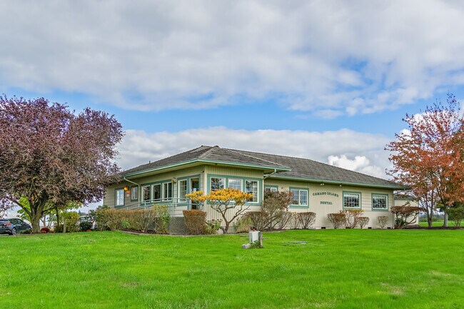


Property Detail
810 Rekdal Rd
R33221-010-2850
35 - W400 OF S173 OF SWSE EX REKDAL RD & ST HWY 525 EX PT TO IS CO AF#92024951 FINAL SITE PLAN 3/92 AF#93003350
Commercialnec
Island
20
Washington
B and X Area of moderate flood hazard, usually the area between the limits of the 100-year and 500-year floods.
1.13 AC
2025
Seattle North/Everett
2025
Other Market Areas
971500
Oak Harbor, WA
2,649 SF
NEARBY LISTINGS FOR SALE OR LEASE
-
-
View all Camano Island listings for sale on LoopNet.com
DEMOGRAPHICS near 810 Rekdal Rd
1 mile
3 mile
5 mile
2025 Total Population
439
4,857
18,163
2030 Population
450
4,882
18,645
Pop Growth 2025-2030
+ 2.51%
+ 0.51%
+ 2.65%
Average Age
49
50
45
2025 Total Households
182
2,019
7,149
HH Growth 2025-2030
+ 2.20%
+ 0.35%
+ 2.49%
Median Household Inc
$89,473
$101,786
$99,478
Avg Household Size
2.40
2.30
2.50
2025 Avg HH Vehicles
2.00
2.00
2.00
Median Home Value
$808,823
$729,479
$696,613
Median Year Built
1977
1990
1995
Nearby Places
Map Layers
Map Styles
 Street
 Aerial
Transit
 Traffic
 Biking
Places
Listings with unknown addresses are not visible on the map
- Restaurants
- Banks
- Shops
- Fitness
- Groceries
PUBLIC TRANSPORTATION
COMMUTER RAIL
Drive
Walk
Distance
7 min
3.9 mi
AIRPORT
Seattle Paine Field International
Drive
Walk
Distance
Seattle Paine Field International
50 min
36.5 mi
Freight Ports
Port of Everett
Drive
Walk
Distance
Port of Everett
40 min
29.0 mi
SALE & LEASE HISTORY
LISTING DATE
SALE/LEASE

Oct 13, 2021
For Sale
Nearby Properties
Address
Land Use
TOTAL SIZE
Lot Size
Zoning
Address
Land Use
TOTAL SIZE
Lot Size
Zoning
119,926 SF
5.33 AC
MR
Address
Land Use
TOTAL SIZE
Lot Size
Zoning
194,176 SF
6.33 AC
UE
Address
Land Use
TOTAL SIZE
Lot Size
Zoning
48,556 SF
19.39 AC
20
Address
Land Use
TOTAL SIZE
Lot Size
Zoning
53,716 SF
9.25 AC
50
Address
Land Use
TOTAL SIZE
Lot Size
Zoning
45,672 SF
1.91 AC
MB2
Address
Land Use
TOTAL SIZE
Lot Size
Zoning
32,845 SF
5.75 AC
SR 7.0
Address
Land Use
TOTAL SIZE
Lot Size
Zoning
36,897 SF
31.78 AC
LM
Address
Land Use
TOTAL SIZE
Lot Size
Zoning
19,838 SF
0.32 AC
MB2
Address
Land Use
TOTAL SIZE
Lot Size
Zoning
11,375 SF
13.60 AC
Address
Land Use
TOTAL SIZE
Lot Size
Zoning
16,163 SF
1.41 AC
MR
Address
Land Use
TOTAL SIZE
Lot Size
Zoning
17,408 SF
1.06 AC
MR
Address
Land Use
TOTAL SIZE
Lot Size
Zoning
28,350 SF
2 AC
UE
Address
Land Use
TOTAL SIZE
Lot Size
Zoning
2,785 SF
0.16 AC
MB2
Address
Land Use
TOTAL SIZE
Lot Size
Zoning
11,515 SF
0.90 AC
MB1
Address
Land Use
TOTAL SIZE
Lot Size
Zoning
10,584 SF
0.29 AC
UE
Address
Land Use
TOTAL SIZE
Lot Size
Zoning
3,735 SF
40 AC
Address
Land Use
TOTAL SIZE
Lot Size
Zoning
12,899 SF
0.49 AC
SR 5.0
Address
Land Use
TOTAL SIZE
Lot Size
Zoning
19,273 SF
0.42 AC
MR
Address
Land Use
TOTAL SIZE
Lot Size
Zoning
10,292 SF
3.27 AC
20
Address
Land Use
TOTAL SIZE
Lot Size
Zoning
6,563 SF
0.20 AC
50
Address
Land Use
TOTAL SIZE
Lot Size
Zoning
11,409 SF
0.28 AC
MB1
Address
Land Use
TOTAL SIZE
Lot Size
Zoning
14,629 SF
2.08 AC
20
Address
Land Use
TOTAL SIZE
Lot Size
Zoning
6,175 SF
0.46 AC
MB1
Address
Land Use
TOTAL SIZE
Lot Size
Zoning
5,444 SF
0.22 AC
50
Address
Land Use
TOTAL SIZE
Lot Size
Zoning
25,608 SF
114.77 AC
A-10
Address
Land Use
TOTAL SIZE
Lot Size
Zoning
11,020 SF
0.73 AC
MR
Address
Land Use
TOTAL SIZE
Lot Size
Zoning
1,836 SF
0.26 AC
GC
Address
Land Use
TOTAL SIZE
Lot Size
Zoning
1,399 SF
70.40 AC
A-10
Address
Land Use
TOTAL SIZE
Lot Size
Zoning
6,260 SF
0.18 AC
Address
Land Use
TOTAL SIZE
Lot Size
Zoning
15,735 SF
4.60 AC
23
The World's #1 Commercial Real Estate Marketplace
Connect with us
© 2026 CoStar Group
The information above has been obtained from sources believed reliable. While we do not doubt its accuracy we have not verified it and make no guarantee, warranty or representation about it. It is your responsibility to independently confirm its accuracy and completeness. Any projections, opinions, assumptions, or estimates used are for example only and do not represent the current or future performance of the property. The value of this transaction to you depends on tax and other factors which should be evaluated by your tax, financial, and legal advisors. You and your advisors should conduct a careful, independent investigation of the property to determine to your satisfaction the suitability of the property for your needs.