Property Record
810 Science Blvd, Columbus, OH 43230


Save to a Folder
{{folder.Name}}
{{folder.ListingIds.length}} Properties
{{folder.ListingIds.length}} Property
Create a New Folder
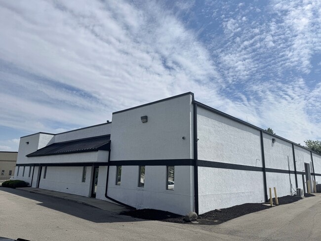
Property Detail
810 Science Blvd
Columbus, OH
TAYLOR ROAD SHALETON 1.269 ACRES
025-011538
FRANKLIN
Industrialgeneral
Ohio
B and X Area of moderate flood hazard, usually the area between the limits of the 100-year and 500-year floods.
23
2024
1.27 AC
2025
Airport
007427
Columbus
12,030 SF
NEARBY LISTINGS FOR SALE OR LEASE
DEMOGRAPHICS near 810 Science Blvd
1 mile
3 mile
5 mile
2025 Total Population
4,487
67,010
228,300
2030 Population
4,607
68,790
234,607
Pop Growth 2025-2030
+ 2.67%
+ 2.66%
+ 2.76%
Average Age
38
39
38
2025 Total Households
1,733
26,876
90,930
HH Growth 2025-2030
+ 2.83%
+ 2.81%
+ 2.86%
Median Household Inc
$100,372
$80,564
$69,898
Avg Household Size
2.60
2.40
2.40
2025 Avg HH Vehicles
2.00
2.00
2.00
Median Home Value
$388,815
$314,271
$282,421
Median Year Built
1994
1985
1983
Nearby Places
Map Layers
Map Styles
 Street
 Aerial
Layers
 Traffic
 Biking
Places
Listings with unknown addresses are not visible on the map
- Restaurants
- Banks
- Shops
- Fitness
- Groceries
PUBLIC TRANSPORTATION
AIRPORT
John Glenn Columbus International
Drive
Walk
Distance
John Glenn Columbus International
12 min
4.0 mi
Rickenbacker International
Drive
Walk
Distance
Rickenbacker International
25 min
15.8 mi
SALE & LEASE HISTORY
LISTING DATE
SALE/LEASE

May 20, 2025
For Lease
Mar 08, 2017
For Lease
Jan 20, 2022
For Lease
Dec 20, 2024
For Lease
Apr 02, 2025
For Sale
Nearby Properties
Address
Land Use
TOTAL SIZE
Lot Size
Zoning
Address
Land Use
TOTAL SIZE
Lot Size
Zoning
316,415 SF
415.78 AC
Address
Land Use
TOTAL SIZE
Lot Size
Zoning
1,256,678 SF
1,292.62 AC
Address
Land Use
TOTAL SIZE
Lot Size
Zoning
Address
Land Use
TOTAL SIZE
Lot Size
Zoning
761,542 SF
21.30 AC
Address
Land Use
TOTAL SIZE
Lot Size
Zoning
180,383 SF
15.54 AC
Address
Land Use
TOTAL SIZE
Lot Size
Zoning
208,472 SF
1.45 AC
Address
Land Use
TOTAL SIZE
Lot Size
Zoning
329,049 SF
38.53 AC
Address
Land Use
TOTAL SIZE
Lot Size
Zoning
164,095 SF
33.71 AC
Address
Land Use
TOTAL SIZE
Lot Size
Zoning
147,649 SF
5.15 AC
Address
Land Use
TOTAL SIZE
Lot Size
Zoning
122,526 SF
27 AC
Address
Land Use
TOTAL SIZE
Lot Size
Zoning
514,341 SF
46.79 AC
Address
Land Use
TOTAL SIZE
Lot Size
Zoning
48,912 SF
45.91 AC
Address
Land Use
TOTAL SIZE
Lot Size
Zoning
282,035 SF
29.29 AC
Address
Land Use
TOTAL SIZE
Lot Size
Zoning
60,056 SF
0.22 AC
Address
Land Use
TOTAL SIZE
Lot Size
Zoning
95,322 SF
10 AC
Address
Land Use
TOTAL SIZE
Lot Size
Zoning
464,796 SF
7.33 AC
Address
Land Use
TOTAL SIZE
Lot Size
Zoning
166,628 SF
9.98 AC
Address
Land Use
TOTAL SIZE
Lot Size
Zoning
706,471 SF
41.34 AC
Address
Land Use
TOTAL SIZE
Lot Size
Zoning
253,893 SF
12.57 AC
Address
Land Use
TOTAL SIZE
Lot Size
Zoning
171,366 SF
28.27 AC
Address
Land Use
TOTAL SIZE
Lot Size
Zoning
122,390 SF
7.77 AC
Address
Land Use
TOTAL SIZE
Lot Size
Zoning
1,264,151 SF
58.42 AC
Address
Land Use
TOTAL SIZE
Lot Size
Zoning
170,209 SF
15.03 AC
Address
Land Use
TOTAL SIZE
Lot Size
Zoning
142,542 SF
6.55 AC
Address
Land Use
TOTAL SIZE
Lot Size
Zoning
15,850 SF
21.65 AC
Address
Land Use
TOTAL SIZE
Lot Size
Zoning
142,542 SF
3.95 AC
Address
Land Use
TOTAL SIZE
Lot Size
Zoning
158,325 SF
34.39 AC
Address
Land Use
TOTAL SIZE
Lot Size
Zoning
173,727 SF
38.26 AC
Address
Land Use
TOTAL SIZE
Lot Size
Zoning
145,592 SF
4.48 AC
Address
Land Use
TOTAL SIZE
Lot Size
Zoning
267,596 SF
5.76 AC
The World's #1 Commercial Real Estate Marketplace
Connect with us
© 2026 CoStar Group
The information above has been obtained from sources believed reliable. While we do not doubt its accuracy we have not verified it and make no guarantee, warranty or representation about it. It is your responsibility to independently confirm its accuracy and completeness. Any projections, opinions, assumptions, or estimates used are for example only and do not represent the current or future performance of the property. The value of this transaction to you depends on tax and other factors which should be evaluated by your tax, financial, and legal advisors. You and your advisors should conduct a careful, independent investigation of the property to determine to your satisfaction the suitability of the property for your needs.