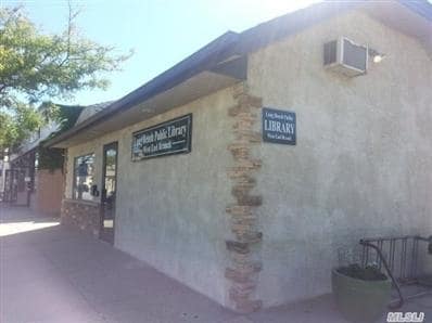
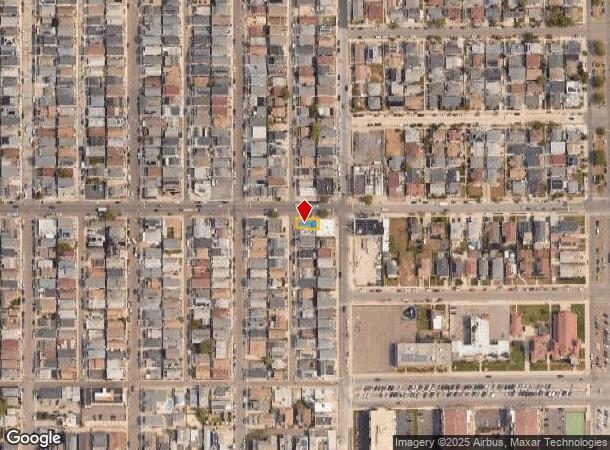
Property Record
810 W Beech St, Long Beach, NY 11561
NEARBY LISTINGS FOR SALE OR LEASE
Property Detail
810 W Beech St
Nassau County-Suffolk County, NY
West End
1000-59-265-00-0001-0
TOWN #5 SCH DIST 028
Commercialnec
Nassau
AE
New York
36059C0308G
1
2025
0.04 AC
2025
Southern Nassau
416402
Long Island (New York)
960 SF
DEMOGRAPHICS near 810 W Beech St
1 Mile
3 Mile
5 Mile
2024 Total Population
14,406
56,218
226,457
2029 Population
14,051
55,035
219,561
Pop Growth 2024-2029
(2.46%)
(2.10%)
(3.05%)
Average Age
44
44
41
2024 Total Households
6,071
23,310
78,533
HH Growth 2024-2029
(2.42%)
(1.98%)
(3.01%)
Median Household Inc
$137,889
$116,107
$100,161
Avg Household Size
2.20
2.30
2.70
2024 Avg HH Vehicles
2.00
2.00
2.00
Median Home Value
$729,173
$717,016
$699,576
Median Year Built
1949
1959
1957
Nearby Places
- Restaurants
- Banks
- Shops
- Fitness
- Groceries
PUBLIC TRANSPORTATION
COMMUTER RAIL
Long Beach Station (Long Beach Branch - Long Island Rail Road)
DRIVE
WALK
Distance
Long Beach Station (Long Beach Branch - Long Island Rail Road)
2 min
1.5 mi
Island Park Station (Long Beach Branch - Long Island Rail Road)
DRIVE
WALK
Distance
Island Park Station (Long Beach Branch - Long Island Rail Road)
5 min
2.7 mi
AIRPORT
John F Kennedy International
DRIVE
WALK
Distance
John F Kennedy International
24 min
13.2 mi
LaGuardia
DRIVE
WALK
Distance
LaGuardia
33 min
19.0 mi
Newark Liberty International
DRIVE
WALK
Distance
Newark Liberty International
60 min
38.7 mi
Freight Ports
NY - Red Hook Container Terminal
DRIVE
WALK
Distance
NY - Red Hook Container Terminal
44 min
23.1 mi
Nearby Properties
Address
Land Use
TOTAL SIZE
Lot Size
Zoning
Address
Land Use
TOTAL SIZE
Lot Size
Zoning
59,673 SF
0.88 AC
R4-1
Address
Land Use
TOTAL SIZE
Lot Size
Zoning
28,520 SF
0.61 AC
R6
Address
Land Use
TOTAL SIZE
Lot Size
Zoning
Address
Land Use
TOTAL SIZE
Lot Size
Zoning
648 SF
111.40 AC
Address
Land Use
TOTAL SIZE
Lot Size
Zoning
350.74 AC
Address
Land Use
TOTAL SIZE
Lot Size
Zoning
197,920 SF
16.50 AC
Address
Land Use
TOTAL SIZE
Lot Size
Zoning
92.92 AC
Address
Land Use
TOTAL SIZE
Lot Size
Zoning
Address
Land Use
TOTAL SIZE
Lot Size
Zoning
66.41 AC
Address
Land Use
TOTAL SIZE
Lot Size
Zoning
1,664 SF
32.13 AC
Address
Land Use
TOTAL SIZE
Lot Size
Zoning
60.30 AC
Address
Land Use
TOTAL SIZE
Lot Size
Zoning
484,552 SF
11.56 AC
Address
Land Use
TOTAL SIZE
Lot Size
Zoning
120,000 SF
39.77 AC
Address
Land Use
TOTAL SIZE
Lot Size
Zoning
45,642 SF
5.07 AC
Address
Land Use
TOTAL SIZE
Lot Size
Zoning
128,438 SF
1.35 AC
Address
Land Use
TOTAL SIZE
Lot Size
Zoning
208,598 SF
3.28 AC
Address
Land Use
TOTAL SIZE
Lot Size
Zoning
5,100 SF
12.27 AC
Address
Land Use
TOTAL SIZE
Lot Size
Zoning
39,192 SF
0.23 AC
Address
Land Use
TOTAL SIZE
Lot Size
Zoning
26.33 AC
Address
Land Use
TOTAL SIZE
Lot Size
Zoning
48,015 SF
16.76 AC
Address
Land Use
TOTAL SIZE
Lot Size
Zoning
224,100 SF
13.06 AC
Address
Land Use
TOTAL SIZE
Lot Size
Zoning
15.81 AC
Address
Land Use
TOTAL SIZE
Lot Size
Zoning
27,989 SF
8.73 AC
Address
Land Use
TOTAL SIZE
Lot Size
Zoning
2,226 SF
1.56 AC
Address
Land Use
TOTAL SIZE
Lot Size
Zoning
166,456 SF
5.47 AC
Address
Land Use
TOTAL SIZE
Lot Size
Zoning
103,266 SF
2.60 AC
Address
Land Use
TOTAL SIZE
Lot Size
Zoning
13.69 AC
Address
Land Use
TOTAL SIZE
Lot Size
Zoning
79,164 SF
1.23 AC
Address
Land Use
TOTAL SIZE
Lot Size
Zoning
84,352 SF
4.35 AC
Address
Land Use
TOTAL SIZE
Lot Size
Zoning
61,632 SF
0.53 AC
The World's #1 Commercial Real Estate Marketplace
Connect with us
© 2025 CoStar Group
The information above has been obtained from sources believed reliable. While we do not doubt its accuracy we have not verified it and make no guarantee, warranty or representation about it. It is your responsibility to independently confirm its accuracy and completeness. Any projections, opinions, assumptions, or estimates used are for example only and do not represent the current or future performance of the property. The value of this transaction to you depends on tax and other factors which should be evaluated by your tax, financial, and legal advisors. You and your advisors should conduct a careful, independent investigation of the property to determine to your satisfaction the suitability of the property for your needs.