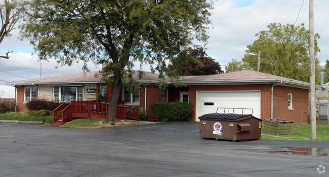
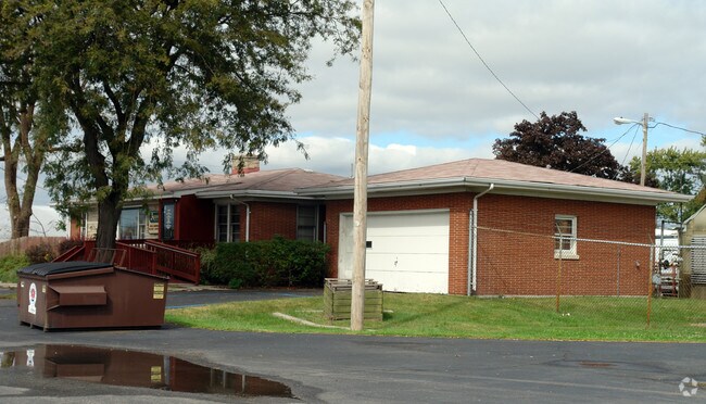
Property Record
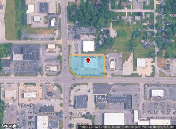
8100 E Ridge Rd, Hobart, IN 46342
NEARBY LISTINGS FOR SALE OR LEASE
Property Detail
8100 E Ridge Rd
Chicago-Naperville-Elgin, IL-IN
Cvs 6913
45-09-21-351-024.000-045
CVS 6913 LOT 1
Storebuilding
Lake
X
Indiana
18127C0111D
1
2024
1.65 AC
2025
Indiana
041800
Chicago
12,996 SF
DEMOGRAPHICS near 8100 E Ridge Rd
1 Mile
3 Mile
5 Mile
2024 Total Population
4,042
50,355
104,169
2029 Population
4,042
50,553
106,113
Pop Growth 2024-2029
0.00%
+ 0.39%
+ 1.87%
Average Age
40
40
40
2024 Total Households
1,572
19,742
41,256
HH Growth 2024-2029
0.00%
+ 0.42%
+ 1.88%
Median Household Inc
$65,025
$58,111
$53,119
Avg Household Size
2.60
2.50
2.50
2024 Avg HH Vehicles
2.00
2.00
2.00
Median Home Value
$175,211
$158,006
$160,124
Median Year Built
1967
1970
1968
Nearby Places
Map Layers
Map Styles
 Street
 Aerial
- Restaurants
- Banks
- Shops
- Fitness
- Groceries
PUBLIC TRANSPORTATION
COMMUTER RAIL
Miller (Gary) Station (South Shore Line - Northern Indiana Commuter Transportation District (South Shore Line))
DRIVE
WALK
Distance
Miller (Gary) Station (South Shore Line - Northern Indiana Commuter Transportation District (South Shore Line))
10 min
4.6 mi
Ogden Dunes (Portage) Station (South Shore Line - Northern Indiana Commuter Transportation District (South Shore Line))
DRIVE
WALK
Distance
Ogden Dunes (Portage) Station (South Shore Line - Northern Indiana Commuter Transportation District (South Shore Line))
15 min
7.0 mi
AIRPORT
Chicago Midway International
DRIVE
WALK
Distance
Chicago Midway International
59 min
38.8 mi
Nearby Properties
Address
Land Use
TOTAL SIZE
Lot Size
Zoning
Address
Land Use
TOTAL SIZE
Lot Size
Zoning
862,805 SF
36.93 AC
R33
Address
Land Use
TOTAL SIZE
Lot Size
Zoning
83,904 SF
15.47 AC
Address
Land Use
TOTAL SIZE
Lot Size
Zoning
159,954 SF
8.49 AC
Address
Land Use
TOTAL SIZE
Lot Size
Zoning
169,427 SF
44 SF
Address
Land Use
TOTAL SIZE
Lot Size
Zoning
161,118 SF
22.13 AC
R33
Address
Land Use
TOTAL SIZE
Lot Size
Zoning
212,330 SF
10.70 AC
Address
Land Use
TOTAL SIZE
Lot Size
Zoning
112,216 SF
44 SF
Address
Land Use
TOTAL SIZE
Lot Size
Zoning
140,434 SF
15.26 AC
Address
Land Use
TOTAL SIZE
Lot Size
Zoning
102,255 SF
3.96 AC
R33
Address
Land Use
TOTAL SIZE
Lot Size
Zoning
48,955 SF
14.50 AC
Address
Land Use
TOTAL SIZE
Lot Size
Zoning
124,160 SF
87 SF
Address
Land Use
TOTAL SIZE
Lot Size
Zoning
31,884 SF
23.22 AC
Address
Land Use
TOTAL SIZE
Lot Size
Zoning
96,488 SF
44 SF
Address
Land Use
TOTAL SIZE
Lot Size
Zoning
37,351 SF
13.74 AC
Address
Land Use
TOTAL SIZE
Lot Size
Zoning
100,690 SF
15.44 AC
Address
Land Use
TOTAL SIZE
Lot Size
Zoning
105,865 SF
9.09 AC
Address
Land Use
TOTAL SIZE
Lot Size
Zoning
46,093 SF
4.66 AC
Address
Land Use
TOTAL SIZE
Lot Size
Zoning
48,228 SF
4.53 AC
Address
Land Use
TOTAL SIZE
Lot Size
Zoning
51,184 SF
2.50 AC
Address
Land Use
TOTAL SIZE
Lot Size
Zoning
67,072 SF
44 SF
Address
Land Use
TOTAL SIZE
Lot Size
Zoning
65,216 SF
7.61 AC
R33
Address
Land Use
TOTAL SIZE
Lot Size
Zoning
16,300 SF
2.31 AC
Address
Land Use
TOTAL SIZE
Lot Size
Zoning
71,682 SF
4.40 AC
Address
Land Use
TOTAL SIZE
Lot Size
Zoning
108,527 SF
44 SF
Address
Land Use
TOTAL SIZE
Lot Size
Zoning
50,712 SF
2.59 AC
Address
Land Use
TOTAL SIZE
Lot Size
Zoning
52,442 SF
4.48 AC
Address
Land Use
TOTAL SIZE
Lot Size
Zoning
29,251 SF
25.96 AC
Address
Land Use
TOTAL SIZE
Lot Size
Zoning
37,252 SF
5.72 AC
Address
Land Use
TOTAL SIZE
Lot Size
Zoning
6,880 SF
6.71 AC
Address
Land Use
TOTAL SIZE
Lot Size
Zoning
37,968 SF
4.14 AC
The World's #1 Commercial Real Estate Marketplace
Connect with us
© 2026 CoStar Group
The information above has been obtained from sources believed reliable. While we do not doubt its accuracy we have not verified it and make no guarantee, warranty or representation about it. It is your responsibility to independently confirm its accuracy and completeness. Any projections, opinions, assumptions, or estimates used are for example only and do not represent the current or future performance of the property. The value of this transaction to you depends on tax and other factors which should be evaluated by your tax, financial, and legal advisors. You and your advisors should conduct a careful, independent investigation of the property to determine to your satisfaction the suitability of the property for your needs.