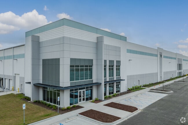
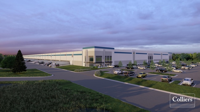
Property Record
8000 Palmetto Commerce Pkwy, North Charleston, SC 29420

Current Lease Availabilities
NEARBY LISTINGS FOR SALE OR LEASE
Property Detail
8000 Palmetto Commerce Pkwy
393-00-00-484
MAPPLATB L21 MAPPLATP 0518-0522 SUBDIVISIONNAME NORTH CHARLESTON TRACT B
Commercialnec
Charleston
2025
South Carolina
2024
North Charleston
010818
Charleston/N Charleston
4,968 SF
Charleston-North Charleston, SC
DEMOGRAPHICS near 8000 Palmetto Commerce Pkwy
1 Mile
3 Mile
5 Mile
2024 Total Population
901
57,673
162,887
2029 Population
967
61,924
179,235
Pop Growth 2024-2029
+ 7.33%
+ 7.37%
+ 10.04%
Average Age
34
36
37
2024 Total Households
456
22,464
62,755
HH Growth 2024-2029
+ 7.24%
+ 7.15%
+ 9.88%
Median Household Inc
$52,792
$59,299
$66,784
Avg Household Size
2.00
2.50
2.50
2024 Avg HH Vehicles
2.00
2.00
2.00
Median Home Value
$175,438
$244,085
$239,290
Median Year Built
2010
1999
1996
Nearby Places
Map Layers
Map Styles
 Street
 Aerial
- Restaurants
- Banks
- Shops
- Fitness
- Groceries
PUBLIC TRANSPORTATION
COMMUTER RAIL
Charleston Amtrak Station (Palmetto - Amtrak, Silver Meteor - Amtrak)
DRIVE
WALK
Distance
Charleston Amtrak Station (Palmetto - Amtrak, Silver Meteor - Amtrak)
14 min
8.8 mi
AIRPORT
Charleston AFB/International
DRIVE
WALK
Distance
Charleston AFB/International
15 min
7.4 mi
Freight Ports
North Charleston Terminal
DRIVE
WALK
Distance
North Charleston Terminal
14 min
8.4 mi
Nearby Properties
Address
Land Use
TOTAL SIZE
Lot Size
Zoning
Address
Land Use
TOTAL SIZE
Lot Size
Zoning
Address
Land Use
TOTAL SIZE
Lot Size
Zoning
48.89 AC
Address
Land Use
TOTAL SIZE
Lot Size
Zoning
1,430 SF
28.27 AC
Address
Land Use
TOTAL SIZE
Lot Size
Zoning
2,917 SF
11.76 AC
HANAHAN -
Address
Land Use
TOTAL SIZE
Lot Size
Zoning
Address
Land Use
TOTAL SIZE
Lot Size
Zoning
10,172 SF
12.76 AC
Address
Land Use
TOTAL SIZE
Lot Size
Zoning
28,770 SF
15.53 AC
Address
Land Use
TOTAL SIZE
Lot Size
Zoning
14.75 AC
Address
Land Use
TOTAL SIZE
Lot Size
Zoning
16.40 AC
Address
Land Use
TOTAL SIZE
Lot Size
Zoning
16.53 AC
Address
Land Use
TOTAL SIZE
Lot Size
Zoning
1,272 SF
18.46 AC
Address
Land Use
TOTAL SIZE
Lot Size
Zoning
Address
Land Use
TOTAL SIZE
Lot Size
Zoning
33.62 AC
Address
Land Use
TOTAL SIZE
Lot Size
Zoning
14.33 AC
Address
Land Use
TOTAL SIZE
Lot Size
Zoning
181,427 SF
16.47 AC
Address
Land Use
TOTAL SIZE
Lot Size
Zoning
101,011 SF
6.58 AC
Address
Land Use
TOTAL SIZE
Lot Size
Zoning
194,515 SF
26.73 AC
Address
Land Use
TOTAL SIZE
Lot Size
Zoning
199,300 SF
13.28 AC
Address
Land Use
TOTAL SIZE
Lot Size
Zoning
Address
Land Use
TOTAL SIZE
Lot Size
Zoning
124,678 SF
65.93 AC
Address
Land Use
TOTAL SIZE
Lot Size
Zoning
126,385 SF
13.45 AC
Address
Land Use
TOTAL SIZE
Lot Size
Zoning
14,725 SF
3.55 AC
Address
Land Use
TOTAL SIZE
Lot Size
Zoning
Address
Land Use
TOTAL SIZE
Lot Size
Zoning
34,131 SF
0.89 AC
Address
Land Use
TOTAL SIZE
Lot Size
Zoning
33,884 SF
10.49 AC
NORTH CHAR
Address
Land Use
TOTAL SIZE
Lot Size
Zoning
67,082 SF
12.07 AC
Address
Land Use
TOTAL SIZE
Lot Size
Zoning
48,400 SF
5.76 AC
Address
Land Use
TOTAL SIZE
Lot Size
Zoning
112.78 AC
Address
Land Use
TOTAL SIZE
Lot Size
Zoning
20,070 SF
8.03 AC
BERKELEY C
Address
Land Use
TOTAL SIZE
Lot Size
Zoning
The World's #1 Commercial Real Estate Marketplace
Connect with us
© 2026 CoStar Group
The information above has been obtained from sources believed reliable. While we do not doubt its accuracy we have not verified it and make no guarantee, warranty or representation about it. It is your responsibility to independently confirm its accuracy and completeness. Any projections, opinions, assumptions, or estimates used are for example only and do not represent the current or future performance of the property. The value of this transaction to you depends on tax and other factors which should be evaluated by your tax, financial, and legal advisors. You and your advisors should conduct a careful, independent investigation of the property to determine to your satisfaction the suitability of the property for your needs.