Property Record
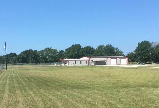
8100 S Us Highway 79, Palestine, TX 75801


Property Detail
8100 S Us Highway 79
R849252
A0020 EWING, EDLEY BLOCK 1171 TRACT 1 (BREEZY HILLS ANNEX LOT 2A)
Commercialnec
Anderson
B and X Area of moderate flood hazard, usually the area between the limits of the 100-year and 500-year floods.
Texas
2025
6.88 AC
2025
Texas East Area
950901
Other Market Areas
4,800 SF
Palestine, TX
NEARBY LISTINGS FOR SALE OR LEASE
DEMOGRAPHICS near 8100 S Us Highway 79
1 mile
3 mile
5 mile
2025 Total Population
355
2,010
7,973
2030 Population
366
2,064
8,161
Pop Growth 2025-2030
+ 3.10%
+ 2.69%
+ 2.36%
Average Age
43
41
41
2025 Total Households
129
733
2,795
HH Growth 2025-2030
+ 3.10%
+ 2.59%
+ 2.40%
Median Household Inc
$55,714
$51,619
$52,555
Avg Household Size
2.60
2.60
2.60
2025 Avg HH Vehicles
2.00
2.00
2.00
Median Home Value
$138,235
$156,177
$178,268
Median Year Built
1997
1981
1983
Nearby Places
Map Layers
Map Styles
 Street
 Aerial
Transit
 Traffic
 Biking
Places
Listings with unknown addresses are not visible on the map
- Restaurants
- Banks
- Shops
- Fitness
- Groceries
SALE & LEASE HISTORY
LISTING DATE
SALE/LEASE

Jan 11, 2022
For Sale
Feb 07, 2018
For Sale
Nearby Properties
Address
Land Use
TOTAL SIZE
Lot Size
Zoning
Address
Land Use
TOTAL SIZE
Lot Size
Zoning
Address
Land Use
TOTAL SIZE
Lot Size
Zoning
1,160,508 SF
247.48 AC
Address
Land Use
TOTAL SIZE
Lot Size
Zoning
1,117.20 AC
Address
Land Use
TOTAL SIZE
Lot Size
Zoning
64,116 SF
2 AC
Address
Land Use
TOTAL SIZE
Lot Size
Zoning
42,060 SF
23.61 AC
Address
Land Use
TOTAL SIZE
Lot Size
Zoning
17,872 SF
15 AC
Address
Land Use
TOTAL SIZE
Lot Size
Zoning
244.11 AC
Address
Land Use
TOTAL SIZE
Lot Size
Zoning
29.05 AC
Address
Land Use
TOTAL SIZE
Lot Size
Zoning
167.29 AC
Address
Land Use
TOTAL SIZE
Lot Size
Zoning
10,700 SF
4 AC
Address
Land Use
TOTAL SIZE
Lot Size
Zoning
13,940 SF
48.66 AC
Address
Land Use
TOTAL SIZE
Lot Size
Zoning
150.47 AC
Address
Land Use
TOTAL SIZE
Lot Size
Zoning
141.12 AC
Address
Land Use
TOTAL SIZE
Lot Size
Zoning
2,242 SF
131.98 AC
Address
Land Use
TOTAL SIZE
Lot Size
Zoning
1,216 SF
121.40 AC
Address
Land Use
TOTAL SIZE
Lot Size
Zoning
5,440 SF
3.35 AC
Address
Land Use
TOTAL SIZE
Lot Size
Zoning
2,376 SF
81.59 AC
Address
Land Use
TOTAL SIZE
Lot Size
Zoning
18,585 SF
2.59 AC
Address
Land Use
TOTAL SIZE
Lot Size
Zoning
6,780 SF
16.34 AC
Address
Land Use
TOTAL SIZE
Lot Size
Zoning
Address
Land Use
TOTAL SIZE
Lot Size
Zoning
3,200 SF
8 AC
Address
Land Use
TOTAL SIZE
Lot Size
Zoning
5,600 SF
2.96 AC
Address
Land Use
TOTAL SIZE
Lot Size
Zoning
98.59 AC
Address
Land Use
TOTAL SIZE
Lot Size
Zoning
2,298 SF
39.67 AC
Address
Land Use
TOTAL SIZE
Lot Size
Zoning
166.19 AC
Address
Land Use
TOTAL SIZE
Lot Size
Zoning
79.08 AC
Address
Land Use
TOTAL SIZE
Lot Size
Zoning
Address
Land Use
TOTAL SIZE
Lot Size
Zoning
630 SF
70 AC
Address
Land Use
TOTAL SIZE
Lot Size
Zoning
320 SF
3.55 AC
The World's #1 Commercial Real Estate Marketplace
Connect with us
© 2026 CoStar Group
The information above has been obtained from sources believed reliable. While we do not doubt its accuracy we have not verified it and make no guarantee, warranty or representation about it. It is your responsibility to independently confirm its accuracy and completeness. Any projections, opinions, assumptions, or estimates used are for example only and do not represent the current or future performance of the property. The value of this transaction to you depends on tax and other factors which should be evaluated by your tax, financial, and legal advisors. You and your advisors should conduct a careful, independent investigation of the property to determine to your satisfaction the suitability of the property for your needs.