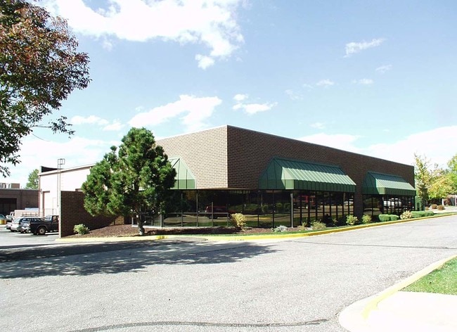
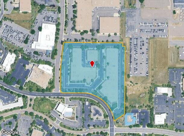
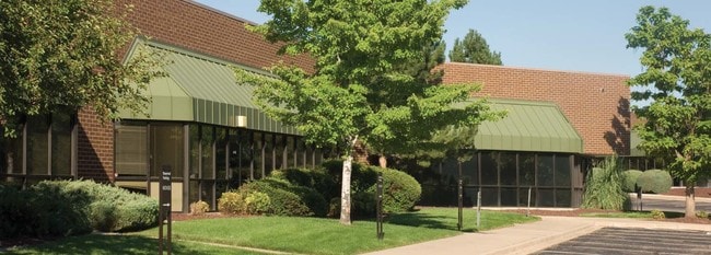
Property Record
8100 Southpark Way, Littleton, CO 80120

NEARBY LISTINGS FOR SALE OR LEASE
Property Detail
8100 Southpark Way
Denver-Aurora-Centennial, CO
Southpark Sub 2Nd Flg
2077-33-4-03-014
SUBDIVISIONCD 058353 SUBDIVISIONNAME SOUTHPARK SUB 2ND FLG BLOCK 000 LOT 003 PART OF LOT 3 DESC AS BEG AT NE COR SD LOT TH S 898.35 FT TH W 25 FT TH S 317.85 FT TO TRUE POB TH S 32.15 FT TH E 25 FT TH S 675.75 FT TH SW 124.82 FT TH ALG CURVE LEFT 464
Warehouse
Arapahoe
X
Colorado
08059C0410F
003,3
2024
8.39 AC
2025
Southwest C-470
005634
Denver
132,946 SF
DEMOGRAPHICS near 8100 Southpark Way
1 Mile
3 Mile
5 Mile
2024 Total Population
7,184
99,221
242,940
2029 Population
7,744
105,777
254,972
Pop Growth 2024-2029
+ 7.80%
+ 6.61%
+ 4.95%
Average Age
44
43
42
2024 Total Households
3,426
39,987
94,901
HH Growth 2024-2029
+ 8.79%
+ 6.66%
+ 4.85%
Median Household Inc
$104,183
$115,510
$117,004
Avg Household Size
2.00
2.40
2.50
2024 Avg HH Vehicles
2.00
2.00
2.00
Median Home Value
$667,381
$638,380
$634,108
Median Year Built
1993
1989
1986
Nearby Places
Map Layers
Map Styles
 Street
 Aerial
- Restaurants
- Banks
- Shops
- Fitness
- Groceries
PUBLIC TRANSPORTATION
AIRPORT
Denver International
DRIVE
WALK
Distance
Denver International
47 min
40.8 mi
Freight Ports
Tulsa Port Of Catoosa
DRIVE
WALK
Distance
Tulsa Port Of Catoosa
739 min
720.7 mi
SALE & LEASE HISTORY
LISTING DATE
SALE/LEASE

Sep 25, 2016
For Lease
Jun 21, 2023
For Lease
Nearby Properties
Address
Land Use
TOTAL SIZE
Lot Size
Zoning
Address
Land Use
TOTAL SIZE
Lot Size
Zoning
867,858 SF
21.49 AC
Address
Land Use
TOTAL SIZE
Lot Size
Zoning
481,147 SF
38.27 AC
Address
Land Use
TOTAL SIZE
Lot Size
Zoning
251,583 SF
38.03 AC
Address
Land Use
TOTAL SIZE
Lot Size
Zoning
187,769 SF
16.09 AC
Address
Land Use
TOTAL SIZE
Lot Size
Zoning
622,103 SF
24.61 AC
PDU
Address
Land Use
TOTAL SIZE
Lot Size
Zoning
206,632 SF
33.68 AC
Address
Land Use
TOTAL SIZE
Lot Size
Zoning
345,126 SF
21.94 AC
Address
Land Use
TOTAL SIZE
Lot Size
Zoning
14,029 SF
23.97 AC
Address
Land Use
TOTAL SIZE
Lot Size
Zoning
42,444 SF
1.41 AC
Address
Land Use
TOTAL SIZE
Lot Size
Zoning
58,006 SF
1.80 AC
Address
Land Use
TOTAL SIZE
Lot Size
Zoning
206,000 SF
70 AC
PDU
Address
Land Use
TOTAL SIZE
Lot Size
Zoning
1,806,344 SF
54.66 AC
Address
Land Use
TOTAL SIZE
Lot Size
Zoning
215,900 SF
15.32 AC
PDU
Address
Land Use
TOTAL SIZE
Lot Size
Zoning
192,108 SF
20.03 AC
Address
Land Use
TOTAL SIZE
Lot Size
Zoning
133,908 SF
9.39 AC
LPD-C
Address
Land Use
TOTAL SIZE
Lot Size
Zoning
177,772 SF
16 AC
Address
Land Use
TOTAL SIZE
Lot Size
Zoning
150,767 SF
14.49 AC
PDU
Address
Land Use
TOTAL SIZE
Lot Size
Zoning
411,924 SF
26.85 AC
LPDI
Address
Land Use
TOTAL SIZE
Lot Size
Zoning
519,330 SF
22.81 AC
PDU
Address
Land Use
TOTAL SIZE
Lot Size
Zoning
484,245 SF
18.06 AC
Address
Land Use
TOTAL SIZE
Lot Size
Zoning
572,657 SF
0.21 AC
LPD-C
Address
Land Use
TOTAL SIZE
Lot Size
Zoning
152,384 SF
12.89 AC
PDU
Address
Land Use
TOTAL SIZE
Lot Size
Zoning
312,130 SF
20.63 AC
PDU
Address
Land Use
TOTAL SIZE
Lot Size
Zoning
1,036,325 SF
51.26 AC
PDU
Address
Land Use
TOTAL SIZE
Lot Size
Zoning
463,840 SF
17.63 AC
PDU
Address
Land Use
TOTAL SIZE
Lot Size
Zoning
290,636 SF
14.54 AC
PDU
Address
Land Use
TOTAL SIZE
Lot Size
Zoning
61,607 SF
11.60 AC
LPD-C
Address
Land Use
TOTAL SIZE
Lot Size
Zoning
65,260 SF
11.15 AC
Address
Land Use
TOTAL SIZE
Lot Size
Zoning
92,913 SF
8.47 AC
LRE
Address
Land Use
TOTAL SIZE
Lot Size
Zoning
87,291 SF
9.25 AC
The World's #1 Commercial Real Estate Marketplace
Connect with us
© 2026 CoStar Group
The information above has been obtained from sources believed reliable. While we do not doubt its accuracy we have not verified it and make no guarantee, warranty or representation about it. It is your responsibility to independently confirm its accuracy and completeness. Any projections, opinions, assumptions, or estimates used are for example only and do not represent the current or future performance of the property. The value of this transaction to you depends on tax and other factors which should be evaluated by your tax, financial, and legal advisors. You and your advisors should conduct a careful, independent investigation of the property to determine to your satisfaction the suitability of the property for your needs.