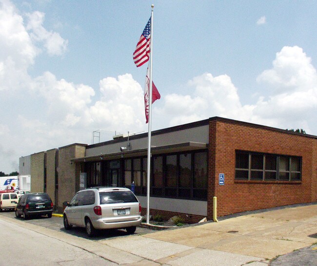
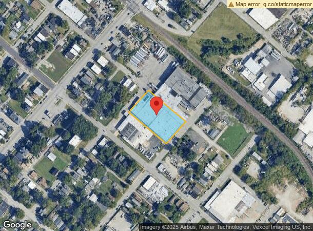
Property Record
8100 Water St, Saint Louis, MO 63111
NEARBY LISTINGS FOR SALE OR LEASE
Property Detail
8100 Water St
3184-00-0010-0
Patch
Industrialgeneral
C. B. 3184 WATER ST 177.03 FT X 295 FT BLK 61 BND S-143.03 FT N 0F DAVIS & 1/2 VAC ST
X
St. Louis City
17133C0020F
Missouri
2024
1.20 AC
2025
St Louis City South
101800
St. Louis
90,337 SF
St. Louis, MO-IL
DEMOGRAPHICS near 8100 Water St
1 Mile
3 Mile
5 Mile
2024 Total Population
6,776
81,185
221,154
2029 Population
6,493
76,904
209,726
Pop Growth 2024-2029
(4.18%)
(5.27%)
(5.17%)
Average Age
39
41
41
2024 Total Households
2,930
35,931
101,517
HH Growth 2024-2029
(4.06%)
(5.37%)
(5.32%)
Median Household Inc
$43,236
$53,079
$58,145
Avg Household Size
2.20
2.20
2.10
2024 Avg HH Vehicles
1.00
2.00
2.00
Median Home Value
$119,057
$152,313
$175,722
Median Year Built
1947
1948
1949
Nearby Places
Map Layers
Map Styles
 Street
 Aerial
- Restaurants
- Banks
- Shops
- Fitness
- Groceries
PUBLIC TRANSPORTATION
COMMUTER RAIL
Shrewsbury-Lansdowne (Shrewsbury-Lansdowne I-44 Emerson Park - St. Louis MetroLink (MetroLink))
DRIVE
WALK
Distance
Shrewsbury-Lansdowne (Shrewsbury-Lansdowne I-44 Emerson Park - St. Louis MetroLink (MetroLink))
12 min
5.5 mi
Sunnen (Shrewsbury-Lansdowne I-44 Emerson Park - St. Louis MetroLink (MetroLink))
DRIVE
WALK
Distance
Sunnen (Shrewsbury-Lansdowne I-44 Emerson Park - St. Louis MetroLink (MetroLink))
16 min
7.2 mi
AIRPORT
St Louis Lambert International
DRIVE
WALK
Distance
St Louis Lambert International
33 min
22.1 mi
Scott AFB/Midamerica St Louis
DRIVE
WALK
Distance
Scott AFB/Midamerica St Louis
50 min
32.4 mi
Freight Ports
Port Milwaukee
DRIVE
WALK
Distance
Port Milwaukee
429 min
376.6 mi
Nearby Properties
Address
Land Use
TOTAL SIZE
Lot Size
Zoning
Address
Land Use
TOTAL SIZE
Lot Size
Zoning
0.92 AC
A
Address
Land Use
TOTAL SIZE
Lot Size
Zoning
5.61 AC
A
Address
Land Use
TOTAL SIZE
Lot Size
Zoning
327,966 SF
56.80 AC
FPC8
Address
Land Use
TOTAL SIZE
Lot Size
Zoning
275,354 SF
72.71 AC
FPM2
Address
Land Use
TOTAL SIZE
Lot Size
Zoning
177.77 AC
A
Address
Land Use
TOTAL SIZE
Lot Size
Zoning
124,890 SF
11.91 AC
J
Address
Land Use
TOTAL SIZE
Lot Size
Zoning
3,835 SF
29.77 AC
R5
Address
Land Use
TOTAL SIZE
Lot Size
Zoning
90,185 SF
407.16 AC
P5
Address
Land Use
TOTAL SIZE
Lot Size
Zoning
22.44 AC
A
Address
Land Use
TOTAL SIZE
Lot Size
Zoning
150,982 SF
18.74 AC
C-8
Address
Land Use
TOTAL SIZE
Lot Size
Zoning
137,432 SF
9.18 AC
C3
Address
Land Use
TOTAL SIZE
Lot Size
Zoning
50.67 AC
A
Address
Land Use
TOTAL SIZE
Lot Size
Zoning
17.93 AC
R5
Address
Land Use
TOTAL SIZE
Lot Size
Zoning
267,886 SF
27.34 AC
R6
Address
Land Use
TOTAL SIZE
Lot Size
Zoning
219,361 SF
9.36 AC
M1
Address
Land Use
TOTAL SIZE
Lot Size
Zoning
Address
Land Use
TOTAL SIZE
Lot Size
Zoning
9.33 AC
R5
Address
Land Use
TOTAL SIZE
Lot Size
Zoning
5.98 AC
R4
Address
Land Use
TOTAL SIZE
Lot Size
Zoning
928 SF
7.25 AC
R5
Address
Land Use
TOTAL SIZE
Lot Size
Zoning
39.88 AC
A
Address
Land Use
TOTAL SIZE
Lot Size
Zoning
89,205 SF
4.72 AC
C-8
Address
Land Use
TOTAL SIZE
Lot Size
Zoning
264,575 SF
1.50 AC
K
Address
Land Use
TOTAL SIZE
Lot Size
Zoning
88,456 SF
10.48 AC
H
Address
Land Use
TOTAL SIZE
Lot Size
Zoning
99,796 SF
36 AC
NU
Address
Land Use
TOTAL SIZE
Lot Size
Zoning
5.58 AC
R4
Address
Land Use
TOTAL SIZE
Lot Size
Zoning
12.14 AC
R5
Address
Land Use
TOTAL SIZE
Lot Size
Zoning
13.81 AC
A
Address
Land Use
TOTAL SIZE
Lot Size
Zoning
102,714 SF
5.74 AC
R6
Address
Land Use
TOTAL SIZE
Lot Size
Zoning
12.25 AC
R5
Address
Land Use
TOTAL SIZE
Lot Size
Zoning
145,540 SF
13.66 AC
H
The World's #1 Commercial Real Estate Marketplace
Connect with us
© 2026 CoStar Group
The information above has been obtained from sources believed reliable. While we do not doubt its accuracy we have not verified it and make no guarantee, warranty or representation about it. It is your responsibility to independently confirm its accuracy and completeness. Any projections, opinions, assumptions, or estimates used are for example only and do not represent the current or future performance of the property. The value of this transaction to you depends on tax and other factors which should be evaluated by your tax, financial, and legal advisors. You and your advisors should conduct a careful, independent investigation of the property to determine to your satisfaction the suitability of the property for your needs.