Property Record
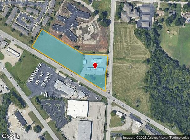
8100 Westridge Rd, Raytown, MO 64138


NEARBY LISTINGS FOR SALE OR LEASE
Property Detail
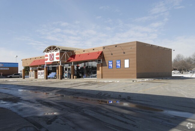
8100 Westridge Rd
44-930-07-01-02-0-00-000
Westridge Park
Storebuilding
WESTRIDGE PARK PT BLK 1 DAF: BEG SE COR BLK 1 TH N 59 DEG W ALG S LI SD BLK 837.62 TH N 30 DEG E 199.99 TH S 59 DEG E ALG N LI BLK 1 & WLY PROLO 464.36 TH S 88 DEG E CONT ALG N
X
Jackson
29095C0402G
Missouri
2024
3.94 AC
2025
East Jackson County
012702
Kansas City
4,420 SF
Kansas City, MO-KS
DEMOGRAPHICS near 8100 Westridge Rd
1 Mile
3 Mile
5 Mile
2024 Total Population
4,761
37,307
117,698
2029 Population
4,688
36,914
117,216
Pop Growth 2024-2029
(1.53%)
(1.05%)
(0.41%)
Average Age
44
41
41
2024 Total Households
1,994
15,088
48,186
HH Growth 2024-2029
(1.71%)
(1.20%)
(0.50%)
Median Household Inc
$71,482
$64,578
$65,834
Avg Household Size
2.30
2.40
2.30
2024 Avg HH Vehicles
2.00
2.00
2.00
Median Home Value
$175,582
$165,952
$187,036
Median Year Built
1973
1967
1972
Nearby Places
Map Layers
Map Styles
 Street
 Aerial
- Restaurants
- Banks
- Shops
- Fitness
- Groceries
PUBLIC TRANSPORTATION
COMMUTER RAIL
Lee's Summit Amtrak (Lincoln Service Missouri River Runner - Amtrak, Missouri River Runner - Amtrak)
DRIVE
WALK
Distance
Lee's Summit Amtrak (Lincoln Service Missouri River Runner - Amtrak, Missouri River Runner - Amtrak)
11 min
6.5 mi
AIRPORT
Kansas City International
DRIVE
WALK
Distance
Kansas City International
46 min
36.2 mi
Freight Ports
Tulsa Port Of Catoosa
DRIVE
WALK
Distance
Tulsa Port Of Catoosa
267 min
243.2 mi
Nearby Properties
Address
Land Use
TOTAL SIZE
Lot Size
Zoning
Address
Land Use
TOTAL SIZE
Lot Size
Zoning
523,783 SF
1.61 AC
Address
Land Use
TOTAL SIZE
Lot Size
Zoning
175,318 SF
26.37 AC
Address
Land Use
TOTAL SIZE
Lot Size
Zoning
82,704 SF
148.69 AC
Address
Land Use
TOTAL SIZE
Lot Size
Zoning
69,771 SF
83.01 AC
Address
Land Use
TOTAL SIZE
Lot Size
Zoning
168,184 SF
18.63 AC
Address
Land Use
TOTAL SIZE
Lot Size
Zoning
389,227 SF
33.30 AC
Address
Land Use
TOTAL SIZE
Lot Size
Zoning
40,902 SF
8.69 AC
Address
Land Use
TOTAL SIZE
Lot Size
Zoning
173,321 SF
40 AC
Address
Land Use
TOTAL SIZE
Lot Size
Zoning
57,442 SF
59.91 AC
Address
Land Use
TOTAL SIZE
Lot Size
Zoning
58,140 SF
1.32 AC
Address
Land Use
TOTAL SIZE
Lot Size
Zoning
Address
Land Use
TOTAL SIZE
Lot Size
Zoning
73,434 SF
10.35 AC
Address
Land Use
TOTAL SIZE
Lot Size
Zoning
47,537 SF
15.70 AC
Address
Land Use
TOTAL SIZE
Lot Size
Zoning
36,546 SF
23.46 AC
Address
Land Use
TOTAL SIZE
Lot Size
Zoning
43,200 SF
4.37 AC
Address
Land Use
TOTAL SIZE
Lot Size
Zoning
35,646 SF
3.25 AC
Address
Land Use
TOTAL SIZE
Lot Size
Zoning
67,570 SF
5.71 AC
Address
Land Use
TOTAL SIZE
Lot Size
Zoning
22,913 SF
151.50 AC
Address
Land Use
TOTAL SIZE
Lot Size
Zoning
49,839 SF
2.97 AC
Address
Land Use
TOTAL SIZE
Lot Size
Zoning
37,401 SF
18.22 AC
Address
Land Use
TOTAL SIZE
Lot Size
Zoning
143,803 SF
9.17 AC
Address
Land Use
TOTAL SIZE
Lot Size
Zoning
36,873 SF
4.31 AC
Address
Land Use
TOTAL SIZE
Lot Size
Zoning
60,372 SF
12.37 AC
Address
Land Use
TOTAL SIZE
Lot Size
Zoning
9,627 SF
10.66 AC
Address
Land Use
TOTAL SIZE
Lot Size
Zoning
76,844 SF
8.26 AC
Address
Land Use
TOTAL SIZE
Lot Size
Zoning
129,087 SF
19.85 AC
Address
Land Use
TOTAL SIZE
Lot Size
Zoning
86,614 SF
9.22 AC
Address
Land Use
TOTAL SIZE
Lot Size
Zoning
91,756 SF
8.48 AC
Address
Land Use
TOTAL SIZE
Lot Size
Zoning
34,344 SF
3.30 AC
Address
Land Use
TOTAL SIZE
Lot Size
Zoning
52,865 SF
5.98 AC
The World's #1 Commercial Real Estate Marketplace
Connect with us
© 2025 CoStar Group
The information above has been obtained from sources believed reliable. While we do not doubt its accuracy we have not verified it and make no guarantee, warranty or representation about it. It is your responsibility to independently confirm its accuracy and completeness. Any projections, opinions, assumptions, or estimates used are for example only and do not represent the current or future performance of the property. The value of this transaction to you depends on tax and other factors which should be evaluated by your tax, financial, and legal advisors. You and your advisors should conduct a careful, independent investigation of the property to determine to your satisfaction the suitability of the property for your needs.