Property Record
8103 Wilmot Rd, Spring Grove, IL 60081

NEARBY LISTINGS FOR SALE OR LEASE
-
-
View all Spring Grove listings for sale on LoopNet.com
Property Detail
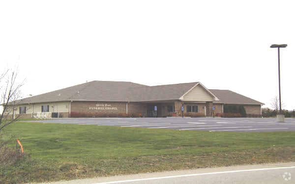
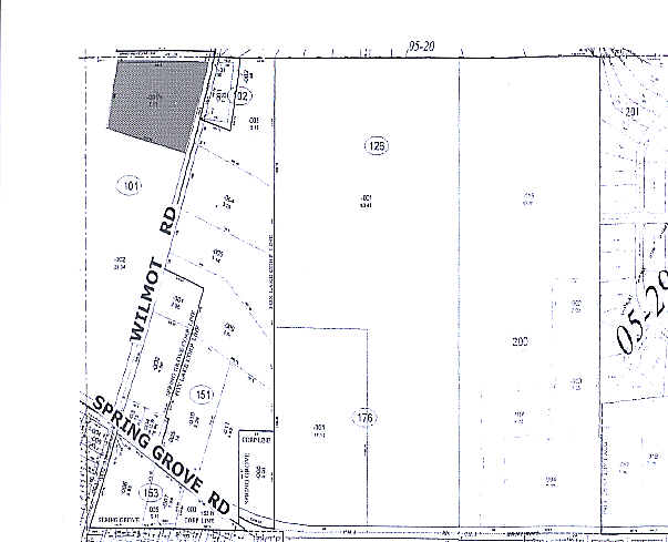
8103 Wilmot Rd
05-29-101-003
Wilmot Rd
Commercialnec
DOC 2014R0023081 PT NW1/4 NW1/4
X
McHenry
17097C0004K
Illinois
2024
4.11 AC
2024
Far Northwest
870105
Chicago
10,287 SF
Chicago-Naperville-Elgin, IL-IN-WI
DEMOGRAPHICS near 8103 Wilmot Rd
1 Mile
3 Mile
5 Mile
2024 Total Population
1,589
14,447
41,742
2029 Population
1,599
14,573
42,139
Pop Growth 2024-2029
+ 0.63%
+ 0.87%
+ 0.95%
Average Age
42
44
44
2024 Total Households
588
5,914
17,256
HH Growth 2024-2029
+ 0.68%
+ 0.88%
+ 0.92%
Median Household Inc
$125,485
$88,003
$81,149
Avg Household Size
2.70
2.40
2.40
2024 Avg HH Vehicles
3.00
2.00
2.00
Median Home Value
$290,673
$261,312
$261,918
Median Year Built
1995
1983
1976
Nearby Places
Map Layers
Map Styles
 Street
 Aerial
- Restaurants
- Banks
- Shops
- Fitness
- Groceries
PUBLIC TRANSPORTATION
COMMUTER RAIL
Fox Lake Station (Milwaukee District North Line - Northeast Illinois Regional Commuter Railroad (Metra))
DRIVE
WALK
Distance
Fox Lake Station (Milwaukee District North Line - Northeast Illinois Regional Commuter Railroad (Metra))
6 min
4.2 mi
Ingleside Station (Milwaukee District North Line - Northeast Illinois Regional Commuter Railroad (Metra))
DRIVE
WALK
Distance
Ingleside Station (Milwaukee District North Line - Northeast Illinois Regional Commuter Railroad (Metra))
11 min
6.2 mi
AIRPORT
Chicago O'Hare International
DRIVE
WALK
Distance
Chicago O'Hare International
63 min
45.2 mi
General Mitchell International
DRIVE
WALK
Distance
General Mitchell International
67 min
47.8 mi
Nearby Properties
Address
Land Use
TOTAL SIZE
Lot Size
Zoning
Address
Land Use
TOTAL SIZE
Lot Size
Zoning
327,323 SF
31.01 AC
Address
Land Use
TOTAL SIZE
Lot Size
Zoning
63,970 SF
7 AC
Address
Land Use
TOTAL SIZE
Lot Size
Zoning
363,291 SF
43 AC
Address
Land Use
TOTAL SIZE
Lot Size
Zoning
7,600 SF
0.50 AC
Address
Land Use
TOTAL SIZE
Lot Size
Zoning
12,620 SF
21.59 AC
Address
Land Use
TOTAL SIZE
Lot Size
Zoning
71,988 SF
4.74 AC
Address
Land Use
TOTAL SIZE
Lot Size
Zoning
75.11 AC
Address
Land Use
TOTAL SIZE
Lot Size
Zoning
46,576 SF
2.68 AC
Address
Land Use
TOTAL SIZE
Lot Size
Zoning
Address
Land Use
TOTAL SIZE
Lot Size
Zoning
95,760 SF
10.46 AC
Address
Land Use
TOTAL SIZE
Lot Size
Zoning
28,216 SF
2.93 AC
Address
Land Use
TOTAL SIZE
Lot Size
Zoning
29,768 SF
2.50 AC
Address
Land Use
TOTAL SIZE
Lot Size
Zoning
47,606 SF
3.34 AC
Address
Land Use
TOTAL SIZE
Lot Size
Zoning
1,513 SF
2.27 AC
Address
Land Use
TOTAL SIZE
Lot Size
Zoning
36,096 SF
2.64 AC
Address
Land Use
TOTAL SIZE
Lot Size
Zoning
47,250 SF
2.70 AC
Address
Land Use
TOTAL SIZE
Lot Size
Zoning
13,765 SF
0.65 AC
Address
Land Use
TOTAL SIZE
Lot Size
Zoning
33,039 SF
77 AC
Address
Land Use
TOTAL SIZE
Lot Size
Zoning
576 SF
53.07 AC
Address
Land Use
TOTAL SIZE
Lot Size
Zoning
3,940 SF
0.37 AC
Address
Land Use
TOTAL SIZE
Lot Size
Zoning
10,786 SF
2 AC
Address
Land Use
TOTAL SIZE
Lot Size
Zoning
79.48 AC
Address
Land Use
TOTAL SIZE
Lot Size
Zoning
18,000 SF
2.07 AC
Address
Land Use
TOTAL SIZE
Lot Size
Zoning
33,500 SF
1.84 AC
Address
Land Use
TOTAL SIZE
Lot Size
Zoning
13,061 SF
0.91 AC
Address
Land Use
TOTAL SIZE
Lot Size
Zoning
4,245 SF
9.57 AC
Address
Land Use
TOTAL SIZE
Lot Size
Zoning
32,034 SF
1.84 AC
Address
Land Use
TOTAL SIZE
Lot Size
Zoning
Address
Land Use
TOTAL SIZE
Lot Size
Zoning
27,920 SF
1 AC
Address
Land Use
TOTAL SIZE
Lot Size
Zoning
The World's #1 Commercial Real Estate Marketplace
Connect with us
© 2026 CoStar Group
The information above has been obtained from sources believed reliable. While we do not doubt its accuracy we have not verified it and make no guarantee, warranty or representation about it. It is your responsibility to independently confirm its accuracy and completeness. Any projections, opinions, assumptions, or estimates used are for example only and do not represent the current or future performance of the property. The value of this transaction to you depends on tax and other factors which should be evaluated by your tax, financial, and legal advisors. You and your advisors should conduct a careful, independent investigation of the property to determine to your satisfaction the suitability of the property for your needs.