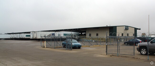
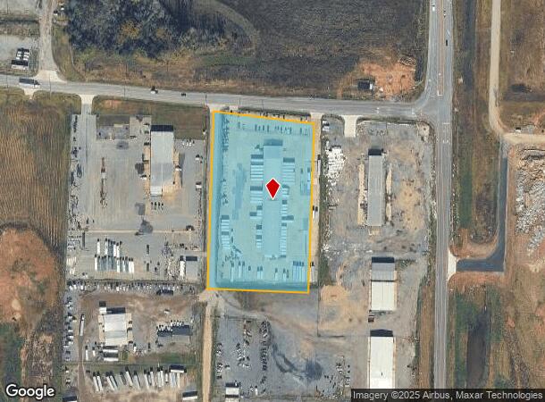
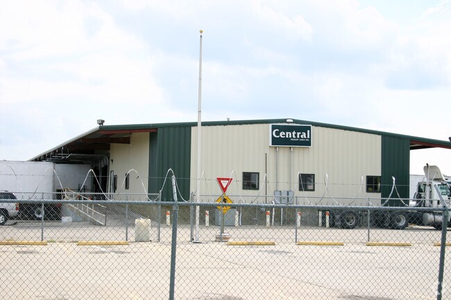
Property Record
8105 Zeuber Rd, Little Rock, AR 72206
NEARBY LISTINGS FOR SALE OR LEASE
Property Detail
8105 Zeuber Rd
24R-021-00-006-04
PT W1/2 SE MPDA COM SE COR SW SE TH N01*2152E AL ELN OF W1/2 SE A DISTANCE OF 1774 66 TH S88*4716 W400 TO POB TH S88*4716W363 S01*5403W PARA WITH & 552.47 FROM WLN OF W1/2 SE A DISTANCE OF 600 S88*4654W368.43 N01*2258 E600 TO POB 21-1N-1
Warehouse
Pulaski
X
Arkansas
05119C0479G
5.08 AC
2025
Outlying Pulaski County
2025
Little Rock/N Little Rock
004007
Little Rock-North Little Rock-Conway, AR
19,450 SF
DEMOGRAPHICS near 8105 Zeuber Rd
1 Mile
3 Mile
5 Mile
2024 Total Population
8
1,905
15,068
2029 Population
8
1,879
15,383
Pop Growth 2024-2029
0.00%
(1.36%)
+ 2.09%
Average Age
42
42
40
2024 Total Households
3
809
6,273
HH Growth 2024-2029
0.00%
(1.48%)
+ 2.12%
Median Household Inc
$87,500
$46,944
$32,306
Avg Household Size
2.00
2.40
2.30
2024 Avg HH Vehicles
2.00
2.00
2.00
Median Home Value
$74,999
$100,242
$97,583
Median Year Built
1974
1984
1974
Nearby Places
Map Layers
Map Styles
 Street
 Aerial
- Restaurants
- Banks
- Shops
- Fitness
- Groceries
PUBLIC TRANSPORTATION
COMMUTER RAIL
Little Rock Union Station (Texas Eagle - Amtrak)
DRIVE
WALK
Distance
Little Rock Union Station (Texas Eagle - Amtrak)
16 min
9.9 mi
AIRPORT
Bill and Hillary Clinton Ntl/Adams Field
DRIVE
WALK
Distance
Bill and Hillary Clinton Ntl/Adams Field
9 min
4.5 mi
Freight Ports
Port of Shreveport
DRIVE
WALK
Distance
Port of Shreveport
256 min
237.5 mi
Nearby Properties
Address
Land Use
TOTAL SIZE
Lot Size
Zoning
Address
Land Use
TOTAL SIZE
Lot Size
Zoning
855,268 SF
82.05 AC
Address
Land Use
TOTAL SIZE
Lot Size
Zoning
379,157 SF
919.20 AC
Address
Land Use
TOTAL SIZE
Lot Size
Zoning
550,000 SF
39.66 AC
Address
Land Use
TOTAL SIZE
Lot Size
Zoning
5,949 SF
25.53 AC
Address
Land Use
TOTAL SIZE
Lot Size
Zoning
345,807 SF
69.54 AC
Address
Land Use
TOTAL SIZE
Lot Size
Zoning
112,500 SF
72.59 AC
Address
Land Use
TOTAL SIZE
Lot Size
Zoning
124,800 SF
23.82 AC
Address
Land Use
TOTAL SIZE
Lot Size
Zoning
31,810 SF
39.99 AC
Address
Land Use
TOTAL SIZE
Lot Size
Zoning
95,472 SF
44.21 AC
Address
Land Use
TOTAL SIZE
Lot Size
Zoning
76,733 SF
Address
Land Use
TOTAL SIZE
Lot Size
Zoning
27,000 SF
9.99 AC
Address
Land Use
TOTAL SIZE
Lot Size
Zoning
272,446 SF
21.74 AC
Address
Land Use
TOTAL SIZE
Lot Size
Zoning
57,648 SF
389.29 AC
Address
Land Use
TOTAL SIZE
Lot Size
Zoning
131,025 SF
176.44 AC
Address
Land Use
TOTAL SIZE
Lot Size
Zoning
1,380 SF
514.53 AC
Address
Land Use
TOTAL SIZE
Lot Size
Zoning
29,792 SF
26.14 AC
Address
Land Use
TOTAL SIZE
Lot Size
Zoning
7,393 SF
38.01 AC
Address
Land Use
TOTAL SIZE
Lot Size
Zoning
8,972 SF
15.89 AC
Address
Land Use
TOTAL SIZE
Lot Size
Zoning
7,216 SF
16.01 AC
Address
Land Use
TOTAL SIZE
Lot Size
Zoning
184,524 SF
10.43 AC
Address
Land Use
TOTAL SIZE
Lot Size
Zoning
2,460 SF
13.33 AC
Address
Land Use
TOTAL SIZE
Lot Size
Zoning
59,117 SF
4.59 AC
Address
Land Use
TOTAL SIZE
Lot Size
Zoning
89,299 SF
153.82 AC
Address
Land Use
TOTAL SIZE
Lot Size
Zoning
128,142 SF
7.83 AC
Address
Land Use
TOTAL SIZE
Lot Size
Zoning
10,659 SF
40.35 AC
Address
Land Use
TOTAL SIZE
Lot Size
Zoning
116,111 SF
25 AC
Address
Land Use
TOTAL SIZE
Lot Size
Zoning
57,808 SF
Address
Land Use
TOTAL SIZE
Lot Size
Zoning
89,518 SF
10 AC
Address
Land Use
TOTAL SIZE
Lot Size
Zoning
16,734 SF
6.80 AC
Address
Land Use
TOTAL SIZE
Lot Size
Zoning
79,853 SF
49.64 AC
The World's #1 Commercial Real Estate Marketplace
Connect with us
© 2025 CoStar Group
The information above has been obtained from sources believed reliable. While we do not doubt its accuracy we have not verified it and make no guarantee, warranty or representation about it. It is your responsibility to independently confirm its accuracy and completeness. Any projections, opinions, assumptions, or estimates used are for example only and do not represent the current or future performance of the property. The value of this transaction to you depends on tax and other factors which should be evaluated by your tax, financial, and legal advisors. You and your advisors should conduct a careful, independent investigation of the property to determine to your satisfaction the suitability of the property for your needs.