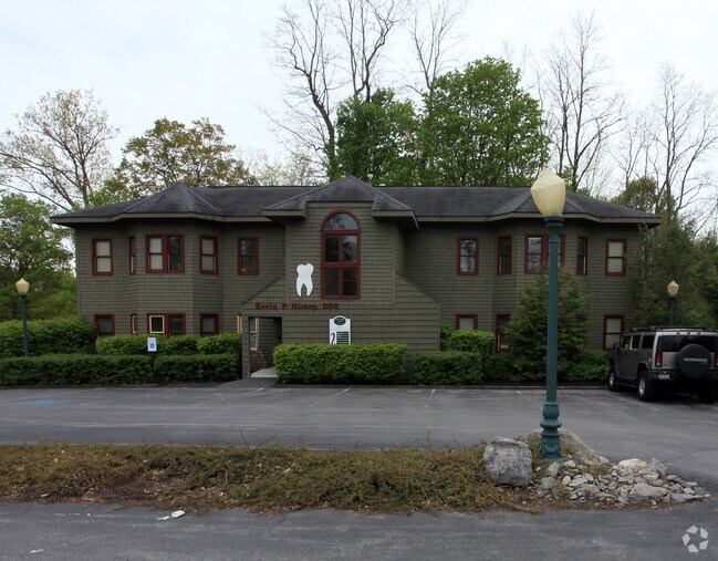
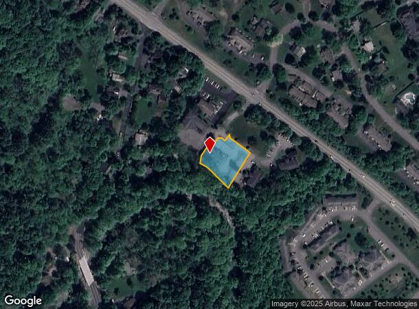
Property Record
8108 Cazenovia Rd, Manlius, NY 13104
NEARBY LISTINGS FOR SALE OR LEASE
Property Detail
8108 Cazenovia Rd
313889-112-000-0002-006-000-0000
FL 77
Officebuilding
Onondaga
X
New York
36067C0377F
6.000
2025
0.57 AC
2024
SE Outer Onondaga County
015203
Syracuse
5,250 SF
Syracuse, NY
DEMOGRAPHICS near 8108 Cazenovia Rd
1 Mile
3 Mile
5 Mile
2024 Total Population
6,435
20,594
33,276
2029 Population
6,321
20,086
32,462
Pop Growth 2024-2029
(1.77%)
(2.47%)
(2.45%)
Average Age
42
43
44
2024 Total Households
2,535
8,082
13,417
HH Growth 2024-2029
(1.97%)
(2.68%)
(2.66%)
Median Household Inc
$100,921
$117,492
$112,618
Avg Household Size
2.50
2.50
2.40
2024 Avg HH Vehicles
2.00
2.00
2.00
Median Home Value
$292,815
$279,171
$271,871
Median Year Built
1979
1975
1974
Nearby Places
Map Layers
Map Styles
 Street
 Aerial
- Restaurants
- Banks
- Shops
- Fitness
- Groceries
PUBLIC TRANSPORTATION
AIRPORT
Syracuse Hancock International
DRIVE
WALK
Distance
Syracuse Hancock International
30 min
18.8 mi
Freight Ports
Albany, NY Port
DRIVE
WALK
Distance
Albany, NY Port
170 min
136.9 mi
SALE & LEASE HISTORY
LISTING DATE
SALE/LEASE

Sep 16, 2020
For Sale
Aug 03, 2020
For Lease
Nearby Properties
Address
Land Use
TOTAL SIZE
Lot Size
Zoning
Address
Land Use
TOTAL SIZE
Lot Size
Zoning
293,638 SF
58.90 AC
R1
Address
Land Use
TOTAL SIZE
Lot Size
Zoning
151,628 SF
38.98 AC
RA
Address
Land Use
TOTAL SIZE
Lot Size
Zoning
6.24 AC
RA
Address
Land Use
TOTAL SIZE
Lot Size
Zoning
4,722 SF
35.39 AC
R5
Address
Land Use
TOTAL SIZE
Lot Size
Zoning
15,240 SF
12.46 AC
R1
Address
Land Use
TOTAL SIZE
Lot Size
Zoning
6,936 SF
13.18 AC
R2
Address
Land Use
TOTAL SIZE
Lot Size
Zoning
26,508 SF
4.38 AC
C
Address
Land Use
TOTAL SIZE
Lot Size
Zoning
116,748 SF
7.67 AC
R1
Address
Land Use
TOTAL SIZE
Lot Size
Zoning
32,094 SF
1.70 AC
B2
Address
Land Use
TOTAL SIZE
Lot Size
Zoning
401,546 SF
24 AC
C
Address
Land Use
TOTAL SIZE
Lot Size
Zoning
5,376 SF
8.91 AC
R2
Address
Land Use
TOTAL SIZE
Lot Size
Zoning
60,621 SF
5.63 AC
C1
Address
Land Use
TOTAL SIZE
Lot Size
Zoning
43,620 SF
33.82 AC
R1
Address
Land Use
TOTAL SIZE
Lot Size
Zoning
13,225 SF
1.48 AC
R2
Address
Land Use
TOTAL SIZE
Lot Size
Zoning
59,066 SF
3.46 AC
R2
Address
Land Use
TOTAL SIZE
Lot Size
Zoning
74,424 SF
35.70 AC
R1
Address
Land Use
TOTAL SIZE
Lot Size
Zoning
4,320 SF
5.67 AC
R4
Address
Land Use
TOTAL SIZE
Lot Size
Zoning
12,787 SF
1.52 AC
C
Address
Land Use
TOTAL SIZE
Lot Size
Zoning
9,616 SF
6.40 AC
R5
Address
Land Use
TOTAL SIZE
Lot Size
Zoning
Address
Land Use
TOTAL SIZE
Lot Size
Zoning
28,037 SF
40.68 AC
C
Address
Land Use
TOTAL SIZE
Lot Size
Zoning
45,285 SF
5.33 AC
C1
Address
Land Use
TOTAL SIZE
Lot Size
Zoning
36,072 SF
2.27 AC
C
Address
Land Use
TOTAL SIZE
Lot Size
Zoning
28,334 SF
3.97 AC
IND
Address
Land Use
TOTAL SIZE
Lot Size
Zoning
1,776 SF
14.74 AC
C
Address
Land Use
TOTAL SIZE
Lot Size
Zoning
35,188 SF
20.90 AC
C
Address
Land Use
TOTAL SIZE
Lot Size
Zoning
9,102 SF
2.08 AC
C
Address
Land Use
TOTAL SIZE
Lot Size
Zoning
37,000 SF
2.54 AC
R1
Address
Land Use
TOTAL SIZE
Lot Size
Zoning
15,186 SF
2.57 AC
RM
Address
Land Use
TOTAL SIZE
Lot Size
Zoning
37,659 SF
2.76 AC
C
The World's #1 Commercial Real Estate Marketplace
Connect with us
© 2025 CoStar Group
The information above has been obtained from sources believed reliable. While we do not doubt its accuracy we have not verified it and make no guarantee, warranty or representation about it. It is your responsibility to independently confirm its accuracy and completeness. Any projections, opinions, assumptions, or estimates used are for example only and do not represent the current or future performance of the property. The value of this transaction to you depends on tax and other factors which should be evaluated by your tax, financial, and legal advisors. You and your advisors should conduct a careful, independent investigation of the property to determine to your satisfaction the suitability of the property for your needs.