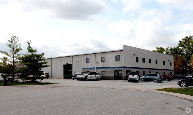
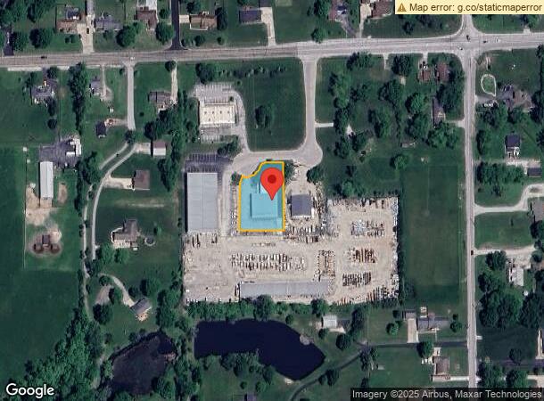
Property Record
8109 Network Dr, Plainfield, IN 46168

NEARBY LISTINGS FOR SALE OR LEASE
Property Detail
8109 Network Dr
32-15-13-353-002.000-011
JDH PLAT LOT 4 0.706AC
Warehouse
Hendricks
X
Indiana
18109C0019E
4
2024
0.71 AC
2024
Plainfield
210701
Indianapolis
9,125 SF
Indianapolis-Carmel-Anderson, IN
DEMOGRAPHICS near 8109 Network Dr
1 Mile
3 Mile
5 Mile
2024 Total Population
1,610
20,697
64,533
2029 Population
1,802
22,393
69,309
Pop Growth 2024-2029
+ 11.93%
+ 8.19%
+ 7.40%
Average Age
42
41
39
2024 Total Households
563
7,184
24,220
HH Growth 2024-2029
+ 11.90%
+ 7.86%
+ 7.54%
Median Household Inc
$120,217
$80,075
$73,983
Avg Household Size
2.80
2.50
2.50
2024 Avg HH Vehicles
2.00
2.00
2.00
Median Home Value
$282,352
$226,444
$213,563
Median Year Built
1985
1984
1992
Nearby Places
Map Layers
Map Styles
 Street
 Aerial
- Restaurants
- Banks
- Shops
- Fitness
- Groceries
PUBLIC TRANSPORTATION
AIRPORT
Indianapolis International
DRIVE
WALK
Distance
Indianapolis International
14 min
7.0 mi
Freight Ports
Port of Toledo
DRIVE
WALK
Distance
Port of Toledo
292 min
241.9 mi
Nearby Properties
Address
Land Use
TOTAL SIZE
Lot Size
Zoning
Address
Land Use
TOTAL SIZE
Lot Size
Zoning
822,500 SF
45.66 AC
Address
Land Use
TOTAL SIZE
Lot Size
Zoning
650,960 SF
31.95 AC
Address
Land Use
TOTAL SIZE
Lot Size
Zoning
651,610 SF
63.52 AC
Address
Land Use
TOTAL SIZE
Lot Size
Zoning
292,315 SF
28.97 AC
Address
Land Use
TOTAL SIZE
Lot Size
Zoning
24.62 AC
Address
Land Use
TOTAL SIZE
Lot Size
Zoning
518,536 SF
25.66 AC
Address
Land Use
TOTAL SIZE
Lot Size
Zoning
551,424 SF
31.39 AC
Address
Land Use
TOTAL SIZE
Lot Size
Zoning
595,100 SF
28.35 AC
Address
Land Use
TOTAL SIZE
Lot Size
Zoning
480,000 SF
40.60 AC
Address
Land Use
TOTAL SIZE
Lot Size
Zoning
476,720 SF
28.97 AC
Address
Land Use
TOTAL SIZE
Lot Size
Zoning
482,016 SF
26.70 AC
Address
Land Use
TOTAL SIZE
Lot Size
Zoning
448,625 SF
23.82 AC
Address
Land Use
TOTAL SIZE
Lot Size
Zoning
454,260 SF
29.55 AC
Address
Land Use
TOTAL SIZE
Lot Size
Zoning
426,088 SF
23.11 AC
Address
Land Use
TOTAL SIZE
Lot Size
Zoning
5,881 SF
17.35 AC
Address
Land Use
TOTAL SIZE
Lot Size
Zoning
442,215 SF
24.69 AC
Address
Land Use
TOTAL SIZE
Lot Size
Zoning
440,198 SF
24.86 AC
Address
Land Use
TOTAL SIZE
Lot Size
Zoning
168,574 SF
8.30 AC
Address
Land Use
TOTAL SIZE
Lot Size
Zoning
363,072 SF
25.08 AC
Address
Land Use
TOTAL SIZE
Lot Size
Zoning
346,808 SF
21.63 AC
Address
Land Use
TOTAL SIZE
Lot Size
Zoning
321,634 SF
18.58 AC
Address
Land Use
TOTAL SIZE
Lot Size
Zoning
11,404 SF
12.58 AC
Address
Land Use
TOTAL SIZE
Lot Size
Zoning
274,534 SF
13.47 AC
Address
Land Use
TOTAL SIZE
Lot Size
Zoning
235,986 SF
34.02 AC
Address
Land Use
TOTAL SIZE
Lot Size
Zoning
353,860 SF
15.40 AC
Address
Land Use
TOTAL SIZE
Lot Size
Zoning
260,400 SF
12.70 AC
Address
Land Use
TOTAL SIZE
Lot Size
Zoning
16,224 SF
14.08 AC
Address
Land Use
TOTAL SIZE
Lot Size
Zoning
220,302 SF
11.59 AC
Address
Land Use
TOTAL SIZE
Lot Size
Zoning
12.57 AC
Address
Land Use
TOTAL SIZE
Lot Size
Zoning
242,017 SF
11.48 AC
The World's #1 Commercial Real Estate Marketplace
Connect with us
© 2025 CoStar Group
The information above has been obtained from sources believed reliable. While we do not doubt its accuracy we have not verified it and make no guarantee, warranty or representation about it. It is your responsibility to independently confirm its accuracy and completeness. Any projections, opinions, assumptions, or estimates used are for example only and do not represent the current or future performance of the property. The value of this transaction to you depends on tax and other factors which should be evaluated by your tax, financial, and legal advisors. You and your advisors should conduct a careful, independent investigation of the property to determine to your satisfaction the suitability of the property for your needs.