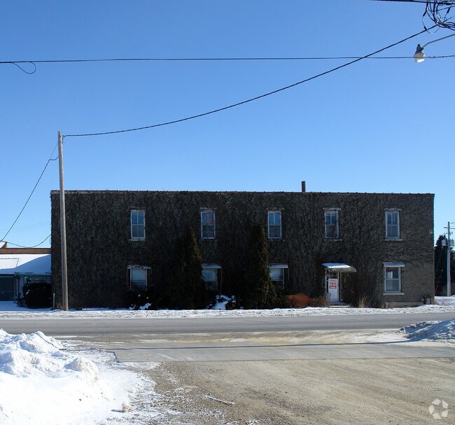
Property Record
811 4Th St Ne, Hampton, IA 50441

Save to a Folder
{{folder.Name}}
{{folder.ListingIds.length}} Properties
{{folder.ListingIds.length}} Property
Create a New Folder
Property Detail
811 4Th St Ne
0727303017
TR IN NW SW 27 COM (SEQ:1), 808.92'S OF NW COR, (SEQ:2), E 80R,S TO RR, W TO (SEQ:3), SEC LN,N EXC TRACT (SEQ:4) WD-2005-0593
Religious
FRANKLIN
B and X Area of moderate flood hazard, usually the area between the limits of the 100-year and 500-year floods.
Iowa
0
10.82 AC
2025
Iowa Northeast Area
360200
Other Market Areas
8,612 SF
NEARBY LISTINGS FOR SALE OR LEASE
-
-
View all Hampton listings for sale on LoopNet.com
DEMOGRAPHICS near 811 4Th St Ne
1 mile
3 mile
5 mile
2025 Total Population
3,974
4,911
5,220
2030 Population
4,047
4,995
5,301
Pop Growth 2025-2030
+ 1.84%
+ 1.71%
+ 1.55%
Average Age
42
42
42
2025 Total Households
1,612
2,001
2,132
HH Growth 2025-2030
+ 1.86%
+ 1.75%
+ 1.59%
Median Household Inc
$50,222
$51,031
$52,278
Avg Household Size
2.40
2.40
2.40
2025 Avg HH Vehicles
2.00
2.00
2.00
Median Home Value
$105,901
$106,784
$110,091
Median Year Built
1957
1956
1956
Nearby Places
Map Layers
Map Styles
 Street
 Aerial
Layers
 Traffic
 Biking
Places
Listings with unknown addresses are not visible on the map
- Restaurants
- Banks
- Shops
- Fitness
- Groceries
Nearby Properties
Address
Land Use
TOTAL SIZE
Lot Size
Zoning
Address
Land Use
TOTAL SIZE
Lot Size
Zoning
105,672 SF
31.49 AC
Address
Land Use
TOTAL SIZE
Lot Size
Zoning
76,026 SF
8.80 AC
Address
Land Use
TOTAL SIZE
Lot Size
Zoning
88,483 SF
22.56 AC
Address
Land Use
TOTAL SIZE
Lot Size
Zoning
2,200 SF
32.12 AC
Address
Land Use
TOTAL SIZE
Lot Size
Zoning
21,702 SF
9.39 AC
Address
Land Use
TOTAL SIZE
Lot Size
Zoning
299,970 SF
21.50 AC
Address
Land Use
TOTAL SIZE
Lot Size
Zoning
15,336 SF
17.23 AC
Address
Land Use
TOTAL SIZE
Lot Size
Zoning
23,212 SF
Address
Land Use
TOTAL SIZE
Lot Size
Zoning
7,248 SF
2.49 AC
Address
Land Use
TOTAL SIZE
Lot Size
Zoning
1,881 SF
11.90 AC
Address
Land Use
TOTAL SIZE
Lot Size
Zoning
26,456 SF
7.57 AC
Address
Land Use
TOTAL SIZE
Lot Size
Zoning
71,816 SF
12.53 AC
Address
Land Use
TOTAL SIZE
Lot Size
Zoning
31,102 SF
3.43 AC
Address
Land Use
TOTAL SIZE
Lot Size
Zoning
22,566 SF
1.60 AC
Address
Land Use
TOTAL SIZE
Lot Size
Zoning
24,320 SF
4.60 AC
Address
Land Use
TOTAL SIZE
Lot Size
Zoning
10,627 SF
4.76 AC
Address
Land Use
TOTAL SIZE
Lot Size
Zoning
48,600 SF
10.13 AC
Address
Land Use
TOTAL SIZE
Lot Size
Zoning
24,758 SF
5.51 AC
Address
Land Use
TOTAL SIZE
Lot Size
Zoning
15,663 SF
2.97 AC
Address
Land Use
TOTAL SIZE
Lot Size
Zoning
17,250 SF
8.25 AC
Address
Land Use
TOTAL SIZE
Lot Size
Zoning
18,174 SF
1.77 AC
Address
Land Use
TOTAL SIZE
Lot Size
Zoning
3,498 SF
5 AC
Address
Land Use
TOTAL SIZE
Lot Size
Zoning
13,396 SF
0.60 AC
Address
Land Use
TOTAL SIZE
Lot Size
Zoning
22,844 SF
0.25 AC
Address
Land Use
TOTAL SIZE
Lot Size
Zoning
3,996 SF
6.04 AC
Address
Land Use
TOTAL SIZE
Lot Size
Zoning
6,400 SF
3.71 AC
Address
Land Use
TOTAL SIZE
Lot Size
Zoning
4,800 SF
13.95 AC
Address
Land Use
TOTAL SIZE
Lot Size
Zoning
30,000 SF
4.13 AC
Address
Land Use
TOTAL SIZE
Lot Size
Zoning
6,714 SF
0.38 AC
The World's #1 Commercial Real Estate Marketplace
Connect with us
© 2026 CoStar Group
The information above has been obtained from sources believed reliable. While we do not doubt its accuracy we have not verified it and make no guarantee, warranty or representation about it. It is your responsibility to independently confirm its accuracy and completeness. Any projections, opinions, assumptions, or estimates used are for example only and do not represent the current or future performance of the property. The value of this transaction to you depends on tax and other factors which should be evaluated by your tax, financial, and legal advisors. You and your advisors should conduct a careful, independent investigation of the property to determine to your satisfaction the suitability of the property for your needs.