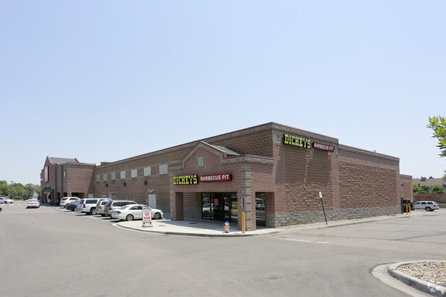
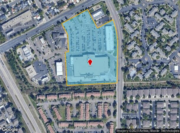
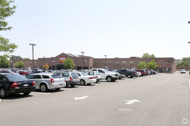
Property Record
811 Cheyenne Meadows Rd, Colorado Springs, CO 80906

NEARBY LISTINGS FOR SALE OR LEASE
Property Detail
811 Cheyenne Meadows Rd
Colorado Springs, CO
Cheyenne Meadows Center Sub Fil No 4
65052-11-002
LOT 1 CHEYENNE MEADOWS CENTER SUB FIL NO 4 CO SPGS
Commercialbuilding
El Paso
AE
Colorado
08041C0743G
1
2024
8.16 AC
2025
Southwest
003308
Colorado Springs
86,698 SF
DEMOGRAPHICS near 811 Cheyenne Meadows Rd
1 Mile
3 Mile
5 Mile
2024 Total Population
15,929
67,190
182,207
2029 Population
16,638
70,370
190,698
Pop Growth 2024-2029
+ 4.45%
+ 4.73%
+ 4.66%
Average Age
37
37
36
2024 Total Households
6,820
26,158
69,531
HH Growth 2024-2029
+ 4.71%
+ 5.07%
+ 5.05%
Median Household Inc
$69,564
$64,303
$60,662
Avg Household Size
2.30
2.40
2.40
2024 Avg HH Vehicles
2.00
2.00
2.00
Median Home Value
$417,742
$401,318
$338,553
Median Year Built
1987
1982
1981
Nearby Places
Map Layers
Map Styles
 Street
 Aerial
- Restaurants
- Banks
- Shops
- Fitness
- Groceries
PUBLIC TRANSPORTATION
AIRPORT
City of Colorado Springs Municipal
DRIVE
WALK
Distance
City of Colorado Springs Municipal
24 min
11.3 mi
Freight Ports
Tulsa Port Of Catoosa
DRIVE
WALK
Distance
Tulsa Port Of Catoosa
750 min
698.0 mi
Nearby Properties
Address
Land Use
TOTAL SIZE
Lot Size
Zoning
Address
Land Use
TOTAL SIZE
Lot Size
Zoning
309,046 SF
28.95 AC
PF SS
Address
Land Use
TOTAL SIZE
Lot Size
Zoning
215,464 SF
11.59 AC
R-5
Address
Land Use
TOTAL SIZE
Lot Size
Zoning
152,977 SF
39.50 AC
MX-M MX-M/
Address
Land Use
TOTAL SIZE
Lot Size
Zoning
168,835 SF
33 AC
PF SS
Address
Land Use
TOTAL SIZE
Lot Size
Zoning
215,377 SF
11.24 AC
R-5/CR
Address
Land Use
TOTAL SIZE
Lot Size
Zoning
983,639 SF
43.31 AC
MX-M CU HR
Address
Land Use
TOTAL SIZE
Lot Size
Zoning
123,644 SF
74.14 AC
GI PF SS
Address
Land Use
TOTAL SIZE
Lot Size
Zoning
49,031 SF
69.16 AC
PCR HS
Address
Land Use
TOTAL SIZE
Lot Size
Zoning
71,438 SF
9.81 AC
R-5/CR
Address
Land Use
TOTAL SIZE
Lot Size
Zoning
601,737 SF
7.24 AC
MX-M
Address
Land Use
TOTAL SIZE
Lot Size
Zoning
99,829 SF
15.39 AC
R-E CU UV
Address
Land Use
TOTAL SIZE
Lot Size
Zoning
107,146 SF
16.72 AC
R-1 6 CU
Address
Land Use
TOTAL SIZE
Lot Size
Zoning
124,107 SF
104.60 AC
MX-N CU
Address
Land Use
TOTAL SIZE
Lot Size
Zoning
166,182 SF
26.35 AC
BP/CR
Address
Land Use
TOTAL SIZE
Lot Size
Zoning
24,293 SF
10.61 AC
C5
Address
Land Use
TOTAL SIZE
Lot Size
Zoning
76,047 SF
5.74 AC
PF
Address
Land Use
TOTAL SIZE
Lot Size
Zoning
46,190 SF
4.02 AC
PDZ
Address
Land Use
TOTAL SIZE
Lot Size
Zoning
66,036 SF
6.70 AC
R-1 6 HS U
Address
Land Use
TOTAL SIZE
Lot Size
Zoning
38,365 SF
3.37 AC
MX-M
Address
Land Use
TOTAL SIZE
Lot Size
Zoning
107,610 SF
5.69 AC
R-E
Address
Land Use
TOTAL SIZE
Lot Size
Zoning
261,184 SF
17.39 AC
MX-M CU
Address
Land Use
TOTAL SIZE
Lot Size
Zoning
28,769 SF
3.92 AC
MX-M
Address
Land Use
TOTAL SIZE
Lot Size
Zoning
60,730 SF
4.26 AC
BP
Address
Land Use
TOTAL SIZE
Lot Size
Zoning
28,641 SF
2.16 AC
R-5 CU
Address
Land Use
TOTAL SIZE
Lot Size
Zoning
48,187 SF
20.46 AC
PCR R-1 6
Address
Land Use
TOTAL SIZE
Lot Size
Zoning
25,457 SF
3.45 AC
PF
Address
Land Use
TOTAL SIZE
Lot Size
Zoning
66,640 SF
6.87 AC
MX-M CU AO
Address
Land Use
TOTAL SIZE
Lot Size
Zoning
30,860 SF
1.71 AC
MX-M CU
Address
Land Use
TOTAL SIZE
Lot Size
Zoning
340,865 SF
13.70 AC
RM-30 RS-6
Address
Land Use
TOTAL SIZE
Lot Size
Zoning
250,137 SF
9.62 AC
MX-M
The World's #1 Commercial Real Estate Marketplace
Connect with us
© 2025 CoStar Group
The information above has been obtained from sources believed reliable. While we do not doubt its accuracy we have not verified it and make no guarantee, warranty or representation about it. It is your responsibility to independently confirm its accuracy and completeness. Any projections, opinions, assumptions, or estimates used are for example only and do not represent the current or future performance of the property. The value of this transaction to you depends on tax and other factors which should be evaluated by your tax, financial, and legal advisors. You and your advisors should conduct a careful, independent investigation of the property to determine to your satisfaction the suitability of the property for your needs.