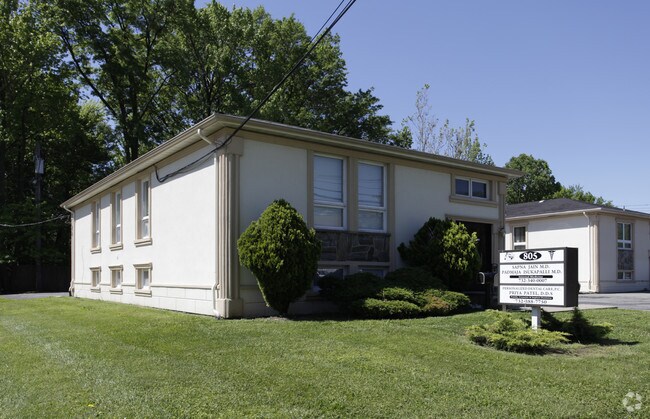
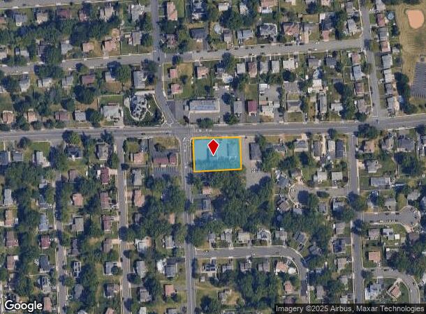
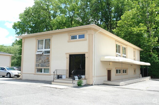
Property Record
805 Inman Ave, Colonia, NJ 07067
NEARBY LISTINGS FOR SALE OR LEASE
Property Detail
805 Inman Ave
New York-Jersey City-White Plains, NY-NJ
.63 ACRES
25-00501-03-00075-04
Middlesex
Medicalbuilding
New Jersey
X
75.4
34023C0052F
0.63 AC
2024
North Edison/Woodbridge
2025
Northern New Jersey
003001
DEMOGRAPHICS near 805 Inman Ave
1 Mile
3 Mile
5 Mile
2024 Total Population
14,923
120,461
394,752
2029 Population
14,802
119,911
392,013
Pop Growth 2024-2029
(0.81%)
(0.46%)
(0.69%)
Average Age
42
41
40
2024 Total Households
4,814
41,106
138,661
HH Growth 2024-2029
(0.87%)
(0.54%)
(0.79%)
Median Household Inc
$140,089
$125,873
$109,770
Avg Household Size
3.00
2.90
2.80
2024 Avg HH Vehicles
2.00
2.00
2.00
Median Home Value
$480,437
$483,715
$450,051
Median Year Built
1963
1966
1960
Nearby Places
Map Layers
Map Styles
 Street
 Aerial
- Restaurants
- Banks
- Shops
- Fitness
- Groceries
PUBLIC TRANSPORTATION
COMMUTER RAIL
Metropark (Northeast Corridor Line - NJ Transit Commuter Rail (NJ Transit))
DRIVE
WALK
Distance
Metropark (Northeast Corridor Line - NJ Transit Commuter Rail (NJ Transit))
6 min
2.5 mi
Rahway (North Jersey Coast Line - NJ Transit Commuter Rail (NJ Transit), Northeast Corridor Line - NJ Transit Commuter Rail (NJ Transit))
DRIVE
WALK
Distance
Rahway (North Jersey Coast Line - NJ Transit Commuter Rail (NJ Transit), Northeast Corridor Line - NJ Transit Commuter Rail (NJ Transit))
8 min
3.7 mi
AIRPORT
Newark Liberty International
DRIVE
WALK
Distance
Newark Liberty International
26 min
17.3 mi
LaGuardia
DRIVE
WALK
Distance
LaGuardia
60 min
36.5 mi
John F Kennedy International
DRIVE
WALK
Distance
John F Kennedy International
60 min
39.3 mi
Freight Ports
New York Container Terminal
DRIVE
WALK
Distance
New York Container Terminal
21 min
12.0 mi
Nearby Properties
Address
Land Use
TOTAL SIZE
Lot Size
Zoning
Address
Land Use
TOTAL SIZE
Lot Size
Zoning
37.46 AC
EI
Address
Land Use
TOTAL SIZE
Lot Size
Zoning
10.11 AC
Address
Land Use
TOTAL SIZE
Lot Size
Zoning
8.43 AC
Address
Land Use
TOTAL SIZE
Lot Size
Zoning
80,000 SF
23.37 AC
R50
Address
Land Use
TOTAL SIZE
Lot Size
Zoning
29.03 AC
IL
Address
Land Use
TOTAL SIZE
Lot Size
Zoning
159,434 SF
11.93 AC
IL
Address
Land Use
TOTAL SIZE
Lot Size
Zoning
19.90 AC
P
Address
Land Use
TOTAL SIZE
Lot Size
Zoning
Address
Land Use
TOTAL SIZE
Lot Size
Zoning
96.22 AC
RA
Address
Land Use
TOTAL SIZE
Lot Size
Zoning
10.15 AC
RA
Address
Land Use
TOTAL SIZE
Lot Size
Zoning
5,645 SF
91.16 AC
O
Address
Land Use
TOTAL SIZE
Lot Size
Zoning
3.87 AC
CG
Address
Land Use
TOTAL SIZE
Lot Size
Zoning
7.63 AC
Address
Land Use
TOTAL SIZE
Lot Size
Zoning
10,173 SF
14.04 AC
OR
Address
Land Use
TOTAL SIZE
Lot Size
Zoning
9.98 AC
RA
Address
Land Use
TOTAL SIZE
Lot Size
Zoning
102,200 SF
6.68 AC
RA
Address
Land Use
TOTAL SIZE
Lot Size
Zoning
Address
Land Use
TOTAL SIZE
Lot Size
Zoning
5.83 AC
RO
Address
Land Use
TOTAL SIZE
Lot Size
Zoning
19.50 AC
LR
Address
Land Use
TOTAL SIZE
Lot Size
Zoning
6.10 AC
RO
Address
Land Use
TOTAL SIZE
Lot Size
Zoning
22.50 AC
LR
Address
Land Use
TOTAL SIZE
Lot Size
Zoning
15.69 AC
R-75
Address
Land Use
TOTAL SIZE
Lot Size
Zoning
66,900 SF
12.75 AC
Address
Land Use
TOTAL SIZE
Lot Size
Zoning
72.50 AC
Address
Land Use
TOTAL SIZE
Lot Size
Zoning
18.61 AC
Address
Land Use
TOTAL SIZE
Lot Size
Zoning
227,149 SF
7.69 AC
IL
Address
Land Use
TOTAL SIZE
Lot Size
Zoning
11.49 AC
RO
Address
Land Use
TOTAL SIZE
Lot Size
Zoning
2.95 AC
CG
Address
Land Use
TOTAL SIZE
Lot Size
Zoning
261,144 SF
10.14 AC
OR
Address
Land Use
TOTAL SIZE
Lot Size
Zoning
10.91 AC
OR
The World's #1 Commercial Real Estate Marketplace
Connect with us
© 2025 CoStar Group
The information above has been obtained from sources believed reliable. While we do not doubt its accuracy we have not verified it and make no guarantee, warranty or representation about it. It is your responsibility to independently confirm its accuracy and completeness. Any projections, opinions, assumptions, or estimates used are for example only and do not represent the current or future performance of the property. The value of this transaction to you depends on tax and other factors which should be evaluated by your tax, financial, and legal advisors. You and your advisors should conduct a careful, independent investigation of the property to determine to your satisfaction the suitability of the property for your needs.