Property Record
811 Polk St, Mansfield, LA 71052
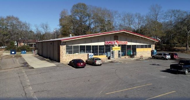

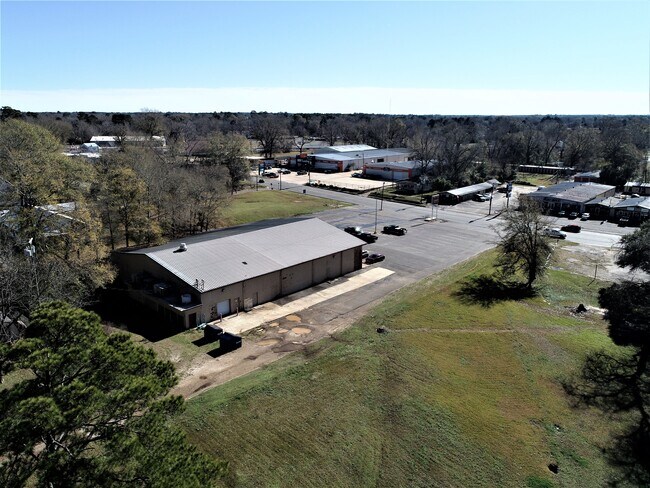
Property Detail
811 Polk St
Shreveport-Bossier City, LA
TRACT 1: BEG AT THE INTERSECTION OF THE W LINE OF MYRA ST & N LINE OF POLK ST, TH RUN W ALONG N LINE POLK ST 100 FT TO PT OF BEG, TH W ALONG N LINE OF POLK ST, 216.3 FT, TH N PARALLEL TO MYRA ST 328.4 FT, TH E PARALLEL TO POLK ST 156.3 FT, S PARALLEL
0400609053
De Soto
Storebuilding
Louisiana
A Areas with a 1% annual chance of flooding and a 26% chance of flooding over the life of a 30-year mortgage.
61
2025
2 AC
2025
DeSoto Parish
950400
Shreveport/Bossier City
NEARBY LISTINGS FOR SALE OR LEASE
DEMOGRAPHICS near 811 Polk St
1 mile
3 mile
5 mile
2025 Total Population
3,656
6,746
7,787
2030 Population
3,697
6,827
7,888
Pop Growth 2025-2030
+ 1.12%
+ 1.20%
+ 1.30%
Average Age
40
40
41
2025 Total Households
1,452
2,758
3,201
HH Growth 2025-2030
+ 1.24%
+ 1.23%
+ 1.34%
Median Household Inc
$32,979
$32,339
$33,503
Avg Household Size
2.30
2.30
2.30
2025 Avg HH Vehicles
1.00
1.00
1.00
Median Home Value
$97,441
$97,543
$104,884
Median Year Built
1979
1979
1980
Nearby Places
Map Layers
Map Styles
 Street
 Aerial
Layers
 Traffic
 Biking
Places
Listings with unknown addresses are not visible on the map
- Restaurants
- Banks
- Shops
- Fitness
- Groceries
PUBLIC TRANSPORTATION
AIRPORT
Shreveport Regional
Drive
Walk
Distance
Shreveport Regional
50 min
34.5 mi
Freight Ports
Port of Shreveport
Drive
Walk
Distance
Port of Shreveport
46 min
26.9 mi
SALE & LEASE HISTORY
LISTING DATE
SALE/LEASE

Sep 24, 2016
For Sale
Oct 23, 2020
For Sale
Nov 23, 2016
For Sale
Jan 07, 2019
For Sale
Feb 10, 2020
For Sale
Nearby Properties
Address
Land Use
TOTAL SIZE
Lot Size
Zoning
Address
Land Use
TOTAL SIZE
Lot Size
Zoning
Address
Land Use
TOTAL SIZE
Lot Size
Zoning
Address
Land Use
TOTAL SIZE
Lot Size
Zoning
Address
Land Use
TOTAL SIZE
Lot Size
Zoning
Address
Land Use
TOTAL SIZE
Lot Size
Zoning
Address
Land Use
TOTAL SIZE
Lot Size
Zoning
Address
Land Use
TOTAL SIZE
Lot Size
Zoning
Address
Land Use
TOTAL SIZE
Lot Size
Zoning
Address
Land Use
TOTAL SIZE
Lot Size
Zoning
Address
Land Use
TOTAL SIZE
Lot Size
Zoning
Address
Land Use
TOTAL SIZE
Lot Size
Zoning
Address
Land Use
TOTAL SIZE
Lot Size
Zoning
Address
Land Use
TOTAL SIZE
Lot Size
Zoning
Address
Land Use
TOTAL SIZE
Lot Size
Zoning
Address
Land Use
TOTAL SIZE
Lot Size
Zoning
Address
Land Use
TOTAL SIZE
Lot Size
Zoning
Address
Land Use
TOTAL SIZE
Lot Size
Zoning
Address
Land Use
TOTAL SIZE
Lot Size
Zoning
Address
Land Use
TOTAL SIZE
Lot Size
Zoning
Address
Land Use
TOTAL SIZE
Lot Size
Zoning
Address
Land Use
TOTAL SIZE
Lot Size
Zoning
Address
Land Use
TOTAL SIZE
Lot Size
Zoning
Address
Land Use
TOTAL SIZE
Lot Size
Zoning
Address
Land Use
TOTAL SIZE
Lot Size
Zoning
Address
Land Use
TOTAL SIZE
Lot Size
Zoning
Address
Land Use
TOTAL SIZE
Lot Size
Zoning
The World's #1 Commercial Real Estate Marketplace
Connect with us
© 2026 CoStar Group
The information above has been obtained from sources believed reliable. While we do not doubt its accuracy we have not verified it and make no guarantee, warranty or representation about it. It is your responsibility to independently confirm its accuracy and completeness. Any projections, opinions, assumptions, or estimates used are for example only and do not represent the current or future performance of the property. The value of this transaction to you depends on tax and other factors which should be evaluated by your tax, financial, and legal advisors. You and your advisors should conduct a careful, independent investigation of the property to determine to your satisfaction the suitability of the property for your needs.